ID: SOS / W.E. Duane
| Title | A Study of the Strood |
| Abstract | A Study of The Strood, Mersea Island, Essex, by Mrs W.E. Duane.
Brentwood Training College 1964/5
This important study is available here - most of it is original typewritten script with real photographs as illustrations. A few pages of note have been attached at some time, probably in the 1980s. See Related Images further down.
Many pages have been transcribed by Doris Christmas and others, but this work is still underway.
Some significant research has been done since the study was written in 1964/5, particularly when water mains were laid across the Strood in 1978 and some of the original piles were recovered and analysed.
The report on this, "Mersea Island: the Anglo-Saxon Causeway" by Philip Crummy, Jennifer Hillam and Carl Crossnan is online
cat.essex.ac.uk/reports/EAS-report-0023.pdf
or there is hardcopy in the Museum Resource Centre in Essex Archaeology and History, Volume 14.
One omission from the work was the Tide Mill at the north end of the Strood. See MBK_EWB_P108 , COR2_027 and Mill on the Strood for more information.
This book is Accession No. 2011.03.001A. There is also a copy in Essex Record Office, reference T/Z 38/23.
Read more:
Strood history page
|
| Author | W.E. Duane |
| Keywords | pile piles |
| Source | Mersea Museum
|
| ID | SOS
|
| Related Images: |
|
 |
| ImageID: | SOS_000_001 | | Title: | A Study of the Strood, Mersea Island, Essex. By W.E. Duane.
Front of the 2-ring binder.
Accession No. 2011.03.001A | | Date: | 1965 | | Source: | Mersea Museum |
|
 |
| ImageID: | SOS_000_003 | | Title: | A Study of the Strood, Mersea Island, Essex, by W.E. Duane.
Brentwood Training College 1964/5 | | Date: | 1965 | | Source: | Mersea Museum |
|
 |
| ImageID: | SOS_000_005 | | Title: | Study of the Strood by W.E. Duane.
Contents | | Date: | 1965 | | Source: | Mersea Museum |
|
 |
| ImageID: | SOS_000_007 | | Title: | Study of the Strood by W.E. Duane.
Acknowledgements | | Date: | 1965 | | Source: | Mersea Museum |
|
 |
| ImageID: | SOS_000_009 | | Title: | Study of the Strood by W.E. Duane.
Illustrations | | Date: | 1965 | | Source: | Mersea Museum |
|
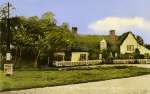 |
| ImageID: | SOS_001_002_001 | | Title: | Postcard of Peldon Rose, West Mersea, from
A Study of the Strood by W.E. Duane. Chapter 1. | | Date: | 1965 | | Source: | Mersea Museum |
|
 |
| ImageID: | SOS_001_003 | | Title: | A Study of the Strood by W.E. Duane. Chapter 1. Page 1.
An Introduction
On approaching the island of Mersea, the first indication that this is the brink of the unusual comes where the roads Colchester and Maldon converge. These meet beside an ancient inn, built in the Century of Agincourt, called the 'Peldon Rose'. This hostelry has played a major role in the story of the island and is featured in the novel 'Mehalah' written by the Rev. Baring-Gould, rector of East Mersea from 1870-1881.
The Peldon Rose has housed carriers, smugglers, wild fowlers, customs men, soldiers of many centuries and natives of the island, known as 'Mersea Men', all of whom at one time or another have had their journey to the island delayed by an element beyond man's control - the tide.
From the 'Peldon Rose' a single highway leads to Mersea Island. It seems to be an ordinary country lane, when suddenly, the hedges fall away and the road is running on an embankment, between white wooden rails with marshes saltings, mud and channels of sea water intermingled on either side.
This causeway is called the Strood and it is the only ...
| | Date: | 1965 | | Source: | Mersea Museum |
|
 |
| ImageID: | SOS_001_004 | | Title: | A Study of the Strood by W.E. Duane. Chapter 1.
The strood at high tide. | | Date: | 1965 | | Source: | Mersea Museum |
|
 |
| ImageID: | SOS_001_004_001 | | Title: | Danger when tide covers footways. Road sign on the approach to the Strood from West Mersea. The other side of the sign says "Try your brakes".
From A Study of the Strood by W.E. Duane. Chapter 1. | | Date: | 1965 | | Source: | Mersea Museum |
|
 |
| ImageID: | SOS_001_005 | | Title: | A Study of the Strood by W.E. Duane. Chapter 1. Page 2.
Introduction contd.
... connecting road that Mersea Island has with the mainland.
Crossing the Strood at high tide can be a hazard for motorist and pedestrian alike, as at the time of the spring tides Mersea is quite definitely an island, the water covering the road, sometimes to a depth of two or three feet. Travellers often spend a pleasant hour at the 'Rose' while waiting for the tide to ebb.
An account of this stretch of road, written on August 17th 1894 in the Amateur Photographer will serve to illustrate how little the scene has altered from that day to this.
"When we have passed Peldon by about a mile, nothing will bar our progress if it be low tide, but if the water be up a double row of posts alone, indicates where there is a crossing, and if it be a strong tide the water will reach the axle of the wheels and the pedestrian must wait. Very rarely is there a boat at hand though sometimes a sailing barge or two will be found.
The channel of water which obstructed our way is the Pye-fleet, crossed here at low tide by a causeway called the Strode and the land beyond is the island of Mersea."
Now, as the water subsides inch by inch and then yard by yard, there is disclosed our road, the Strood, which at the southern end divides at the base of an incline, the left fork leading to East Mersea and the right fork to the larger village of West Mersea.
As a regular visitor to West Mersea, I have traversed the Strood many times, but familiarity has not lessened the ...
| | Date: | 1965 | | Source: | Mersea Museum |
|
 |
| ImageID: | SOS_001_007 | | Title: | A Study of the Strood by W.E. Duane. Chapter 1. Page 3.
Introduction contd.
... fresh sense of adventure that is felt at every crossing, whether going to or leaving the Island. It is this extra ordinary feeling that has led me to explore the early life of Mersea Island in general and the Strood in particular.
| | Date: | 1965 | | Source: | Mersea Museum |
|
 |
| ImageID: | SOS_002_001 | | Title: | A Study of the Strood by W.E. Duane. Chapter 2. Page 4.
The Origins of the Island and the Strood
When embarking on an investigation of this sort, it is always difficult to decide on a point at which to commence. Begin at the beginning is always sound advice, so the chosen point will be to try and fid out how the Island began and why it has a causeway instead of a bridge or the ferry one might expect to find.
The geographical structure of Mersea Island differs from most other Essex coasts; islands in that a good proportion of the land is over fifty feet above sea level and the island has not been formed, in the main, by growth of the marshland from below sea level. Evidence of the island's antiquity is found on consulting a geographical map.
The frontispiece of the Victoria County History of Essex is such a map dated 1903. It shows Mersea predominantly London Clay with patches of overlying glacial gravel and sand, more prominent at the West of the island, on both sides of the Hard. The clay extends to the East end of the island beyond Coopers Beach and stops short of the coast, about level with Mersea Stone. Small patches of glacial gravel ...
| | Date: | 1965 | | Source: | Mersea Museum |
|
 |
| ImageID: | SOS_002_002 | | Title: | Roman Tomb on the wheel design at rear of West Mersea Hall. Photocopy from Victoria County History Vol. 3.
A Study of the Strood by W.E. Duane. Chapter 2. | | Date: | 1965 | | Source: | Mersea Museum |
|
 |
| ImageID: | SOS_002_003 | | Title: | A Study of the Strood by W.E. Duane. Chapter 2. Page 5.
The Origins of the Island and the Strood contd.
... and sand. On the North coast especially, are shown developments of recent alluvium which are matched by similar deposits emanating from the mainland.
The patches of glacial gravel are the clue to the island's long existence, the text of The Victorian History says,
"Glacial gravel occurs around Colchester at Brightlingsea and St. Osyth and there are patches at Mersea Island, Tolleshunt and Tiptree Heath. Some of these deposits may indeed represent stages in the denudation of the country which followed the recession of the ice sheet".
Remains of the Stone Age have been found at the East End of the Island. Well preserved arrowheads and spears of flint, picked up near the beach are on view in Colchester Museum and a large deposit of mammoth bones, also found there, are in the hands of the Natural History Museum at Colchester.
Evidence that the Romans lived on Mersea is available in the gardens of West Mersea Hall and Yew Tree House, near West Mersea Church, where there is a fine example of tessellated pavement to be seen. Behind West Mersea Hall there are the remains of a Roman tomb, built on the wheel design. Mersea is thought to have been the country residence of a high Roman Official stationed in Colchester.
There has been some doubt as to whether Mersea was ...
| | Date: | 1965 | | Source: | Mersea Museum |
|
 |
| ImageID: | SOS_002_004 | | Title: | Red Hill on Bower Hall Farm East Mersea. Natural secion caused by Erosion of the Pyefleet. Drawing by H.A. Cole August 1896. Photocopy from Essex Naturalist Vol. 14 1896.
From A Study of the Strood by W.E. Duane. Chapter 2. | | Date: | 1965 | | Source: | Mersea Museum |
|
 |
| ImageID: | SOS_002_005 | | Title: | A Study of the Strood by W.E. Duane. Chapter 2. Page 6.
The Origins of the Island and the Strood contd.
... an island in Roman times. Allowing for the regular sinkage of the land mass and a corresponding rise in the sea level and also the fact that the old boundaries of West Mersea, once included the mainland manors of Fingringhoe and Pete Hall, there is good reason to think this might be so.
To support this view there is the presence of the Red Hills of the North coast of the island. These patches of earth consist of reddish heaps of soil which show evidence of being burnt. On excavation, the hills are found to contain fragments of tile and pottery. Red Hills are found on the mainland at Walton-on-Naze, Goldhanger, Fingringhoe and Langenhoe. It is significant that one of the sites at Bower Hall Farm, Mersea Island, is directly opposite a similar site across the Pyefleet Channel at Langenhoe and that the fragments of pottery found at Bower Hall have been exposed by erosion of the land by the action of the sea. It is thought that the deepening of the Pyefleet may have cut through the land mass dividing what was once a large Red Hill into two.
The introductory note to a report read at the Society of Antiquaries in London on March 19th 1908 says:-
"Scattered along the margins of the estuaries and tidal river of Essex, are many curios deposits of red burnt clay, intermingled with fragments
of rude pottery, to which the name Red Hills has been given. These Red Hills vary in size from a few rods to several acres. That they date from
a remote period and that, some at least, are prehistoric is proved by the ...
| | Date: | 1965 | | Source: | Mersea Museum |
|
 |
| ImageID: | SOS_002_006 | | Title: | Pottery fragments from the Red Hill, Bower Hall Farm, East Mersea. Photocopy from Red Hills by H. Wilmer.
Pottery from a Red Hill at Ivy House Farm, East Mersea.
From A Study of the Strood by W.E. Duane. Chapter 2. | | Date: | 1965 | | Source: | Mersea Museum |
|
 |
| ImageID: | SOS_002_007 | | Title: | A Study of the Strood by W.E. Duane. Chapter 2. Page 7.
The Origins of the Island and the Strood contd.
... nature of the pottery in them. The purpose which they served has long been a matter for speculation. By some they have been regarded as salt works: by others as cattle shelters, human habitations, potteries or glass factories. To settle the mystery the Essex Archaeological Society set up the Red Hills Exploration Committee 1906-7.
At previous excavations made in August 1892, made by Mr. W. Cole and four colleagues at Bower Hall Farm, Mersea Island, they found fragments of pottery which were examined by me are clearly fragments such as are found on Romano-British sites".
This finding disposes of the theory that the remains are pre-historic - but it does help bolster the theory that the Island was once part of the mainland, since almost identical fragments of pottery have been found in the Langenhoe site on the opposite bank of the channel.
Evidence to support the view that there has been some sort of causeway since Roman times was put forward at the beginning of this century. In 1915 excavations took place at Barrow Hill, which is situated on rising ground a little distance from the Strood. The mound was opened by members of the Essex Archaeological Society and in it was found, enclosed in a leaden ossory, a beautiful perfectly preserved glass vase containing cremated human bones.
Examination of these remains has put the date of the interment at the latter half of the first century and the construction of the Barrow as the
work of a non-Roman people ...
| | Date: | 1965 | | Source: | Mersea Museum |
|
 |
| ImageID: | SOS_002_008 | | Title: | Glass Bowl containing Burnt Bones and Leaden Box in which it was placed, from the Tomb under the Great Barrow on Mersea Island, Essex.
From A Study of the Strood by W.E. Duane. Chapter 2. | | Date: | 1965 | | Source: | Mersea Museum |
|
![A Study of the Strood by W.E. Duane. Chapter 2. Page 8.
</p><p>
The Origins of the Island and the Strood contd.
</p><p>
... living under Roman influence. These remains can now be seen in Colchester Museum.
</p><p class=inner>
Mr Hazzledine Warren [ Note 1 ] says:-
Half a mile to the N.W. of the mound is the artificial causeway known as the Strood-way, which connects Mersea Island with the mainland. This causeway forms a water parting between the Pyefleet Channel on the east and the Strood Channel on the west and is submerged only at high spring tides. It is commonly supposed to be a Roman work, but whether this is so or not, I am unable to say. I have not found any pottery or other relics in association with it. Immediately to the North of the mound, there is a spot where the Pyefleet Channel is crossed by an ancient and long disused ford made of hard material which must have been brought there artificially. It seems, to my mind, probable that it was this ancient ford, rather than the comparatively modern-looking Strood-way, which afforded means of access to Mersea Island at the date of the Barrow and constructed whenever that may have been.
</p><p>
Mr Hazzledine goes further and suggests that the Barrow was constructed to act as an intermediary signal station for the Romans. From the Castle at Colchester to Orthona, site of the Roman Fort at Bradwell, the Barrow is in direct line.
</p><p>
Traces of charcoal and other burnt material, such as would have been used for beacons, have been searched for on top of the Barrow but none have been found to substantiate this theory.
</p><p>
I studied last July copies of aerial photograph [Note 2] of the Pyefleet and these show the terrain in great detail.
</p><p>
Note 1. Trans. E.A.S. Vol.13. Page 119.
Note 2. 6 in aerial photographs C.P. Dept.
</p> SOS_002_009](MMThumbnails30/SOS_002_009.jpg) |
| ImageID: | SOS_002_009 | | Title: | A Study of the Strood by W.E. Duane. Chapter 2. Page 8.
The Origins of the Island and the Strood contd.
... living under Roman influence. These remains can now be seen in Colchester Museum.
Mr Hazzledine Warren [ Note 1 ] says:-
"Half a mile to the N.W. of the mound is the artificial causeway known as the Strood-way, which connects Mersea Island with the mainland. This causeway forms a water parting between the Pyefleet Channel on the east and the Strood Channel on the west and is submerged only at high spring tides. It is commonly supposed to be a Roman work, but whether this is so or not, I am unable to say. I have not found any pottery or other relics in association with it. Immediately to the North of the mound, there is a spot where the Pyefleet Channel is crossed by an ancient and long disused ford made of hard material which must have been brought there artificially. It seems, to my mind, probable that it was this ancient ford, rather than the comparatively modern-looking Strood-way, which afforded means of access to Mersea Island at the date of the Barrow and constructed whenever that may have been".
Mr Hazzledine goes further and suggests that the Barrow was constructed to act as an intermediary signal station for the Romans. From the Castle at Colchester to Orthona, site of the Roman Fort at Bradwell, the Barrow is in direct line.
Traces of charcoal and other burnt material, such as would have been used for beacons, have been searched for on top of the Barrow but none have been found to substantiate this theory.
I studied last July copies of aerial photograph [Note 2] of the Pyefleet and these show the terrain in great detail.
Note 1. Trans. E.A.S. Vol.13. Page 119.
Note 2. 6" in aerial photographs C.P. Dept.
| | Date: | 1965 | | Source: | Mersea Museum |
|
 |
| ImageID: | SOS_002_010 | | Title: | A Study of the Strood by W.E. Duane. Chapter 2. Page 9.
The Origins of the Island and the Strood contd.
I could see no evidence visible at low tide of this ancient ford of which Mr Hazzledine saw remnants in 1915 and I hope to provide evidence during the course of this study to prove that the site of the present roadway is the original one. Local legend has it that the present Strood is haunted by the ghost of a Roman centurion, who still guards the road, even in its modern guise and I would hesitate to argue with such an authority that he was guarding the wrong site!
| | Date: | 1965 | | Source: | Mersea Museum |
|
![A Study of the Strood by W.E. Duane. Chapter 3. Page 10.
</p><p>
The Development of the Strood from Early Maps.
</p><p>
To try and establish the site of the Strood a study of the oldest maps available was made to establish when the Strood , as a road, was first
recorded. There is at the Essex Records Office [Note 1] a large selection, so it seemed, that it was just a matter of finding where the Strood was first shown as a proper thoroughfare and then turning up the documents for that particular period to back up the discovery of its' origin.
</p><p>
The earliest map was made by Christopher Saxton in 1576 [Note 2]. Here, Mersea Island is shown situated in the Estuary of the Colne, with positively no connection with the Blackwater! Some familiar names are marked, East Mersey, West Mersey, Bowre (Bower Hall), but no road, pathway or ford to the mainland is shown.
</p><p>
Hans Wontneel made the next map in 1602 (2) scale 1- 21/4m. This is very similar to Saxton's with the Island still in the estuary of the Colne, but turned a little so that its' length lies from East to West across the Colne. No path or road to the mainland is shown. On this map the villages are named East Marsey and West Marsey.
</p><p>
John Speed's map 1610 [Note 2] scale 1 - 3m shows the Island
</p><p>
Note 1 1st Supplement Catalogue of maps E.R.O.
Note 2 County Maps E.R.O.
</p> SOS_003_001](MMThumbnails30/SOS_003_001.jpg) |
| ImageID: | SOS_003_001 | | Title: | A Study of the Strood by W.E. Duane. Chapter 3. Page 10.
The Development of the Strood from Early Maps.
To try and establish the site of the Strood a study of the oldest maps available was made to establish when the Strood , as a road, was first
recorded. There is at the Essex Records Office [Note 1] a large selection, so it seemed, that it was just a matter of finding where the Strood was first shown as a proper thoroughfare and then turning up the documents for that particular period to back up the discovery of its' origin.
The earliest map was made by Christopher Saxton in 1576 [Note 2]. Here, Mersea Island is shown situated in the Estuary of the Colne, with positively no connection with the Blackwater! Some familiar names are marked, East Mersey, West Mersey, Bowre (Bower Hall), but no road, pathway or ford to the mainland is shown.
Hans Wontneel made the next map in 1602 (2) scale 1"- 21/4m. This is very similar to Saxton's with the Island still in the estuary of the Colne, but turned a little so that its' length lies from East to West across the Colne. No path or road to the mainland is shown. On this map the villages are named East Marsey and West Marsey.
John Speed's map 1610 [Note 2] scale 1" - 3m shows the Island
Note 1 1st Supplement Catalogue of maps E.R.O.
Note 2 County Maps E.R.O.
| | Date: | 1965 | | Source: | Mersea Museum |
|
 |
| ImageID: | SOS_003_002 | | Title: | A Study of the Strood by W.E. Duane. Chapter 3.
Diagram from J. Warburton/s Map 1726. | | Date: | 1726 | | Source: | Mersea Museum |
|
![A Study of the Strood by W.E. Duane. Chapter 3. Page 11.
</p><p>
The Development of the Strood from Early Maps contd.
</p><p>
still in the Colne but with two small islands placed in the Channel opposite Peldon and Langehoe. No path or road is shown connecting the Island to the mainland.
</p><p>
Jan Jansson mad a map in 1636 [Note 1] which showed more indentation of the surrounding marshland, but no path or road across the Pyefleet Channel is recorded.
</p><p>
No further change in any map occurs until John Ogilby and William Morgan's map was published in 1678 1 scale 1 - 3m. On their map the Island is named Mearsey and it has moved a little from the Colne estuary towards the Blackwater but there is still no indication of a path or road across to the mainland.
</p><p>
In 1700 [Note 1] Robert Morden and Joseph Pak made a map to the scale of 1 - 2m which is dedicated to the Nobility and Gentry and contains all roads actually surveyed and measured. The Island is at last correctly placed but no path or road leads to the mainland, in fact, no roads are shown on the Island at all!
</p><p>
John Warburton's map of 1726 [ Note 1] to the scale 1 - 2 1/4m shows a great advance. The Island is named Mersey and is correctly placed. The Strood named 'Stroud' is shown not crossing the Pyefleet Channel, but as two portions of unfenced road, one from East Mersey and one from West Mersey, joining at the base of the hill and continuing until the water's edge.
</p><p>
Note 1 County Maps E.R.O.
</p> SOS_003_003](MMThumbnails30/SOS_003_003.jpg) |
| ImageID: | SOS_003_003 | | Title: | A Study of the Strood by W.E. Duane. Chapter 3. Page 11.
The Development of the Strood from Early Maps contd.
still in the Colne but with two small islands placed in the Channel opposite Peldon and Langehoe. No path or road is shown connecting the Island to the mainland.
Jan Jansson mad a map in 1636 [Note 1] which showed more indentation of the surrounding marshland, but no path or road across the Pyefleet Channel is recorded.
No further change in any map occurs until John Ogilby and William Morgan's map was published in 1678 1 scale 1" - 3m. On their map the Island is named Mearsey and it has moved a little from the Colne estuary towards the Blackwater but there is still no indication of a path or road across to the mainland.
In 1700 [Note 1] Robert Morden and Joseph Pak made a map to the scale of 1" - 2m which is dedicated to "the Nobility and Gentry and contains all roads actually surveyed and measured". The Island is at last correctly placed but no path or road leads to the mainland, in fact, no roads are shown on the Island at all!
John Warburton's map of 1726 [ Note 1] to the scale 1" - 2 1/4m shows a great advance. The Island is named Mersey and is correctly placed. The Strood named 'Stroud' is shown not crossing the Pyefleet Channel, but as two portions of unfenced road, one from East Mersey and one from West Mersey, joining at the base of the hill and continuing until the water's edge.
Note 1 County Maps E.R.O.
| | Date: | 1965 | | Source: | Mersea Museum |
|
 |
| ImageID: | SOS_003_004_001 | | Title: | Mill House Peldon, site of the old mill mentioned in 1551.
From A Study of the Strood by W.E. Duane. Chapter 3. | | Date: | 1965 | | Source: | Mersea Museum |
|
![A Study of the Strood by W.E. Duane. Chapter 3. Pge 12.
</p><p>
The Development of the Strood from Early Maps contd.
</p><p>
... No way across the water is indicated but the road is marked as fence on the other side of the Pyefleet on the mainland.
</p><p>
The next map 1749 [Note 1] made by Emmanuel Bowen to the scale 1 - 3m has detail of the Strood, named 'Stroud' in the same manner as Warburton's in 1726 but a later map made in 1762 by Bowen and John Gibson to the scale 1 - 3 ¾m shows unfenced roads leading to the road junction at the base of the hill and the road continues fenced across the Channel and joins the road to Langenhoe on the other side. The road is given no name and the Island remains named Mersey.
</p><p>
Fifteen years later in 1777 [ Note 1] John Andrews and Andrew Drury made A Map of the County 65 miles round London on 10 Sheets. This was more
detailed work to the scale 1 - 11/4m and on Sheet 5 the Island is named Mersea and the Strood is shown as the Strode. On both approaches to the
Channel from either side the road is shown unfenced but where the route crosses the water it is shown as a fenced road. This map shows the
location of 'Strode Mill' for the first time. The present Mill House on the approach rod to Mersea from Colchester does not appear to be the
original building, although it is on the site indicated for the Mill in 1777. The house ...</p>
<p>
Note 1
County Maps E.R.O.
</p> SOS_003_005](MMThumbnails30/SOS_003_005.jpg) |
| ImageID: | SOS_003_005 | | Title: | A Study of the Strood by W.E. Duane. Chapter 3. Pge 12.
The Development of the Strood from Early Maps contd.
... No way across the water is indicated but the road is marked as fence on the other side of the Pyefleet on the mainland.
The next map 1749 [Note 1] made by Emmanuel Bowen to the scale 1" - 3m has detail of the Strood, named 'Stroud' in the same manner as Warburton's in 1726 but a later map made in 1762 by Bowen and John Gibson to the scale 1" - 3 ¾m shows unfenced roads leading to the road junction at the base of the hill and the road continues fenced across the Channel and joins the road to Langenhoe on the other side. The road is given no name and the Island remains named Mersey.
Fifteen years later in 1777 [ Note 1] John Andrews and Andrew Drury made A Map of the County 65 miles round London on 10 Sheets". This was more
detailed work to the scale 1" - 11/4m and on Sheet 5 the Island is named Mersea and the Strood is shown as the Strode. On both approaches to the
Channel from either side the road is shown unfenced but where the route crosses the water it is shown as a fenced road. This map shows the
location of 'Strode Mill' for the first time. The present Mill House on the approach rod to Mersea from Colchester does not appear to be the
original building, although it is on the site indicated for the Mill in 1777. The house ...
Note 1
County Maps E.R.O.
| | Date: | 1965 | | Source: | Mersea Museum |
|
 |
| ImageID: | SOS_003_006 | | Title: | A Study of the Strood by W.E. Duane. Chapter 3.
Chapman and Andre Map of Essex 1777.
See MAP_1777_WNS for map. | | Date: | 1965 | | Source: | Mersea Museum |
|
![A Study of the Strood by W.E. Duane. Chapter 3. Page 13.
</p><p>
The Development of the Strood from Early Maps contd.
</p><p>
... gives the outward appearance of an early Victorian Villa with a yard and single storey brick outhouses. No land masses such as the Ray in the Strood Channel or the saltings in the Pyefleet are shown on this map.
</p><p>
John Chapman and Peter André show it as unfenced from the limit of the mainland to the rising ground on the Island.
</p><p>
In 1781 [Note 1] Bowles New Pocket Map of Essex was produced, scale 1 - 3m. This shows the road from Langenhoe on to Mersea Island as fenced roadway as does John Carey's 1789 Map of Essex from the best Authorities Engraved. Bowles names the Island as Mersey but Carry names it Mersea.
</p><p>
On his New Pocket Map, Bowles shows the Ray in the correct position but in the reprints of this in 1801 an 1811 he alters the spelling of Mersea to Mercey.
</p><p>
In 1804 Charles Smith produced a New map of the County of Essex, Divided into Hundreds. Scale 1 - 3m. Mersea Island lies in the Hundred of
Winstree and, on this map, is named Mercey. The Strood, which is clearly marked 'Strode' takes on a new ...
</p><p>
Note 1 County Maps E.R.O. SOS_003_007](MMThumbnails30/SOS_003_007.jpg) |
| ImageID: | SOS_003_007 | | Title: | A Study of the Strood by W.E. Duane. Chapter 3. Page 13.
The Development of the Strood from Early Maps contd.
... gives the outward appearance of an early Victorian Villa with a yard and single storey brick outhouses. No land masses such as the Ray in the Strood Channel or the saltings in the Pyefleet are shown on this map.
John Chapman and Peter André show it as unfenced from the limit of the mainland to the rising ground on the Island.
In 1781 [Note 1] Bowles New Pocket Map of Essex was produced, scale 1" - 3m. This shows the road from Langenhoe on to Mersea Island as fenced roadway as does John Carey's "1789 Map of Essex from the best Authorities Engraved". Bowles names the Island as Mersey but Carry names it Mersea.
On his New Pocket Map, Bowles shows the Ray in the correct position but in the reprints of this in 1801 an 1811 he alters the spelling of Mersea to Mercey.
In 1804 Charles Smith produced a "New map of the County of Essex, Divided into Hundreds". Scale 1" - 3m. Mersea Island lies in the Hundred of
Winstree and, on this map, is named Mercey. The Strood, which is clearly marked 'Strode' takes on a new ...
Note 1 County Maps E.R.O. | | Date: | 1965 | | Source: | Mersea Museum |
|
![A Study of the Strood by W.E. Duane. Chapter 3. Page 14.
</p><p>The Development of the Strood from Early Maps contd.
</p><p>
... significance, having a black line along one side. The key denotes that this indicates a mail road and reference to the Post Office Directory 1859 states that:-
</p> <p class=inner>
mails to West Mersea arrive by mail cart through Colchester at 7 a.m. and are dispatched at 6 p.m..
</p><p>
Three years later Nathaniel Coltman renames the island Mersea once more and the 'Strode' is marked on his map as a cross country road [Note 1].
</p><p>
From 1807 onwards there is little variation in the published maps, until we come to the County Surveyors' Department Map dated 1947 [ Note 1].
Scale ½ - 1m The Strood is clearly marked on the map and is shown as a second class county road, incorporated into the B1025. There has been no further change in this clarification as reference to the current Ordnance Survey Map Sheet T.M.10 dated 1955 will show.
</p><p>
Although the spellings of the road and place names often vary, the one constant fact that comes from this study of maps is that wherever the Strood is marked as a connecting link with the mainland, it is always indicated at the same site. There has been no change of location since it was first shown on the 1762 map by Emmanuel Bowen and John Gibson.
</p><p>
It could also be thought as a result of this study that the Strood must have been constructed during the years ...
</p><p>
Note 1 County Maps E.R.O. SOS_003_008](MMThumbnails30/SOS_003_008.jpg) |
| ImageID: | SOS_003_008 | | Title: | A Study of the Strood by W.E. Duane. Chapter 3. Page 14.
The Development of the Strood from Early Maps contd.
... significance, having a black line along one side. The key denotes that this indicates a mail road and reference to the Post Office Directory 1859 states that:-
"mails to West Mersea arrive by mail cart through Colchester at 7 a.m. and are dispatched at 6 p.m..
Three years later Nathaniel Coltman renames the island Mersea once more and the 'Strode' is marked on his map as a "cross country road" [Note 1].
From 1807 onwards there is little variation in the published maps, until we come to the County Surveyors' Department Map dated 1947 [ Note 1].
Scale ½" - 1m The Strood is clearly marked on the map and is shown as a second class county road, incorporated into the B1025. There has been no further change in this clarification as reference to the current Ordnance Survey Map Sheet T.M.10 dated 1955 will show.
Although the spellings of the road and place names often vary, the one constant fact that comes from this study of maps is that wherever the Strood is marked as a connecting link with the mainland, it is always indicated at the same site. There has been no change of location since it was first shown on the 1762 map by Emmanuel Bowen and John Gibson.
It could also be thought as a result of this study that the Strood must have been constructed during the years ...
Note 1 County Maps E.R.O. | | Date: | 1965 | | Source: | Mersea Museum |
|
 |
| ImageID: | SOS_003_009 | | Title: | A Study of the Strood by W.E. Duane. Chapter 3. Page 15.
The Development of the Strood from Early Maps contd.
... 1726 - 1762, because it is not marked on the map for 1726, yet it appears as a fenced road on the map of 1762.
I thought this piece of research had narrowed my field of research to this period but investigation into other sources has only served to prove that the Cartographers of the 18th Century did not arrive at the same degree of accuracy, as we have come to expect of Her Majesty's Ordnance Survey Department today. | | Date: | 1965 | | Source: | Mersea Museum |
|
![A Study of the Strood by W.E. Duane. Chapter 4. Page 16.
</p><p>
The Early Settlement of Mersea Island
</p><p>
The variety of spellings of both Mersea and the Strood which were found on the study of the maps would seem to lead to the next field of research.
</p><p>
The name of a place of site is often the first identification that it has, so perhaps a study of the place-names will yield some clue towards establishing the origin and siting of the Stood.
</p><p>
Meres-ig, Maeres-ig, Meresai and Meresaia, are some of the early spellings of Mersea and reference to the standard works on derivations has brought forward the following opinions.
</p><p>
Morant in his History of Essex [Note 1] says:-
the name is formed from Saxon words, 'Mere' the sea or marsh and 'ig' an island, unless the first part of the name should be derived from the word 'Maera', the extremities or boundary, this being a boundary here against the sea, but the former appears to me the most probable.
</p><p>
Saxon origins of the name are also given in the Place-Names of Essex by P.H. Reany [Note 2]
Meres-ig(e) c. 895 A.S.C. (A)
- Island of the Pool, Mere denotes a pool in Old English.
Here it is probably used of the major inlet from the sea formed by the estuaries of the Colne and Blackwater. The ...
</p><p>
Note 1 Page 424. Morant History of Essex.
Note 2 Page 320. Place-Names of Essex
</p> SOS_004_001](MMThumbnails30/SOS_004_001.jpg) |
| ImageID: | SOS_004_001 | | Title: | A Study of the Strood by W.E. Duane. Chapter 4. Page 16.
The Early Settlement of Mersea Island
The variety of spellings of both Mersea and the Strood which were found on the study of the maps would seem to lead to the next field of research.
The name of a place of site is often the first identification that it has, so perhaps a study of the place-names will yield some clue towards establishing the origin and siting of the Stood.
Meres-ig, Maeres-ig, Meresai and Meresaia, are some of the early spellings of Mersea and reference to the standard works on derivations has brought forward the following opinions.
Morant in his History of Essex [Note 1] says:-
"the name is formed from Saxon words, 'Mere' the sea or marsh and 'ig' an island, unless the first part of the name should be derived from the word 'Maera', the extremities or boundary, this being a boundary here against the sea, but the former appears to me the most probable."
Saxon origins of the name are also given in the Place-Names of Essex by P.H. Reany [Note 2]
"Meres-ig(e) c. 895 A.S.C. (A)
- Island of the Pool", Mere denotes a pool in Old English.
Here it is probably used of the major inlet from the sea formed by the estuaries of the Colne and Blackwater. The ...
Note 1 Page 424. Morant History of Essex.
Note 2 Page 320. Place-Names of Essex
| | Date: | 1965 | | Source: | Mersea Museum |
|
![A Study of the Strood by W.E. Duane. Chapter 4. 17.
</p><p>
The Early Settlement of Mersea Island contd.
</p><p>
... text of the A.S.C. A 895 says:-
</p><p class=inner>
[Note 1] 1on an island paet is ute on paere sae, paet is Mersig. The Anglo-Saxon Chronicle [Note 2] describes how, when the Danes were turned
back from Wales with the booty they had captured there,
they went so that the English army could not reach them, across Northumbria and into East Anglia until they came into east Essex on to
an island called Mersea, which is out in the sea.
[ Note 3] Then that same year in early winter the Dames who were encamped on Mersea rowed their ships up the Thames and up the Lea.
</p><p>
The Strood is given as Strodeway in the Catalogue of Ancient Deeds 1455 and its meaning as marshy land.
</p><p>
The last source consulted [Note 4] lists the name as deriving from the Old English 'Mere' meaning 'mere or lake. The meaning sea is rare, but found here in Mersea. 'Eg, icg,eye' are all from Old English, meaning island. 'Meresaie' as named in the Domesday Book, is listed as 'the island in the sea'. In the same book, the name Strood is said to derive from the Old English, 'Strod or Strop' meaning 'marshy land overgrown with brushwood'.
</p><p>
These early names surely point to the fact that Mersea has undoubtedly been an island since the first inhabitants ...
</p><p>
Note 1 Page 320 Place-Names of Essex.
Note 2 Page 187 English Historical Documents Vol. 1.
Note 3 Page 188 English Historical Documents. Vol. 1.
Note 4 Oxford Dictionary of English Place-Names
</p> SOS_004_002](MMThumbnails30/SOS_004_002.jpg) |
| ImageID: | SOS_004_002 | | Title: | A Study of the Strood by W.E. Duane. Chapter 4. 17.
The Early Settlement of Mersea Island contd.
... text of the A.S.C. A 895 says:-
[Note 1] "1on an island paet is ute on paere sae, paet is Mersig." The Anglo-Saxon Chronicle [Note 2] describes how, when the Danes were turned
back from Wales with the booty they had captured there,
"they went so that the English army could not reach them, across Northumbria and into East Anglia until they came into east Essex on to
an island called Mersea, which is out in the sea."
[ Note 3] "Then that same year in early winter the Dames who were encamped on Mersea rowed their ships up the Thames and up the Lea."
The Strood is given as "Strodeway" in the Catalogue of Ancient Deeds 1455 and its meaning as "marshy land".
The last source consulted [Note 4] lists the name as deriving from the Old English 'Mere' meaning 'mere or lake. The meaning sea is rare, but found here in Mersea. 'Eg, icg,eye' are all from Old English, meaning island. 'Meresaie' as named in the Domesday Book, is listed as 'the island in the sea'. In the same book, the name Strood is said to derive from the Old English, 'Strod or Strop' meaning 'marshy land overgrown with brushwood'.
These early names surely point to the fact that Mersea has undoubtedly been an island since the first inhabitants ...
Note 1 Page 320 Place-Names of Essex.
Note 2 Page 187 English Historical Documents Vol. 1.
Note 3 Page 188 English Historical Documents. Vol. 1.
Note 4 Oxford Dictionary of English Place-Names
| | Date: | 1965 | | Source: | Mersea Museum |
|
 |
| ImageID: | SOS_004_003 | | Title: | A Study of the Strood by W.E. Duane. Chapter 4.
Translation of the original grant of the Manor of West Mersea. Photocopy from Essex Review Vol 51 Page 32.
Manorial Rolls of Fingringhoe, West Mersea and Peter Hall, 1547 to 1558. | | Date: | 1547 | | Source: | Mersea Museum |
|
![A Study of the Strood by W.E. Duane. Chapter 4. Page 18.
</p><p>
The Early Settlement of Mersea Island contd.
</p><p>
... gave it it's descriptive name
and following from this, the inhabitants must have needed some means of connecting with the mainland, so perhaps the Strood was first constructed by strewing a pathway of faggots of brushwood across the muddy floor of the Channel at low tide.
</p><p>
To find out who did need a pathway across the Channel the text of Essex Domesday by J.Horace Round was consulted. Here we find a detailed inventory of everything that could be listed. The island then, as now was divided into two parishes, East and West Mersea and the boundaries of each were occasioned by the manor holdings. The boundary of West Mersea is fully described as follows:-
</p><p class=inner>
There is still a 'Deramy Stone' [Note 1] in Mersea, a boundary mark of the manor of Peet. The bounds given in a Charter of 1046 start from the bank above 'Pone streme' and extend to a ditch formerly called 'Deramy's Diche' between Est-Mersey and West-Mersey, (Broad Fleet) and from 'Deramy's Flete' to a street formerly called 'Deramy's Strete', and from there extends as far as 'le Peete' called 'Deramay's Peete' in the vill of Fyngerynho at 'Deramy's Stone', and from 'Deramy's Stone' to 'Brigflete' on the East and from 'Deramy's Stone' to 'Weldon-Downes Neowte'.
</p><p>
Round [Note 2] says:-
</p><p class=inner>
Hundret of Winisistreu (Winstree) MERESAI (East Mersea), which was held in King Edwards time by Robert Fity Winarc (Winarcae) as a manor and as 6 hides, is held by Suen in Demense and there follows a census of all things of value to the manor.
</p><p>
Note 1 Vol.XII The Place Names of Essex
Note 2 Page 488 V.C.H. Page IX.
</p> SOS_004_004](MMThumbnails30/SOS_004_004.jpg) |
| ImageID: | SOS_004_004 | | Title: | A Study of the Strood by W.E. Duane. Chapter 4. Page 18.
The Early Settlement of Mersea Island contd.
... gave it it's descriptive name
and following from this, the inhabitants must have needed some means of connecting with the mainland, so perhaps the Strood was first constructed by strewing a pathway of faggots of brushwood across the muddy floor of the Channel at low tide.
To find out who did need a pathway across the Channel the text of Essex Domesday by J.Horace Round was consulted. Here we find a detailed inventory of everything that could be listed. The island then, as now was divided into two parishes, East and West Mersea and the boundaries of each were occasioned by the manor holdings. The boundary of West Mersea is fully described as follows:-
"There is still a 'Deramy Stone' [Note 1] in Mersea, a boundary mark of the manor of Peet. The bounds given in a Charter of 1046 start from the bank above 'Pone streme' and extend to a ditch formerly called 'Deramy's Diche' between Est-Mersey and West-Mersey, (Broad Fleet) and from 'Deramy's Flete' to a street formerly called 'Deramy's Strete', and from there extends as far as 'le Peete' called 'Deramay's Peete' in the vill of Fyngerynho at 'Deramy's Stone', and from 'Deramy's Stone' to 'Brigflete' on the East and from 'Deramy's Stone' to 'Weldon-Downes Neowte'.
Round [Note 2] says:-
"Hundret of Winisistreu (Winstree) MERESAI (East Mersea), which was held in King Edwards time by Robert Fity Winarc (Winarcae) as a manor and as 6 hides, is held by Suen in Demense" and there follows a census of all things of value to the manor.
Note 1 Vol.XII The Place Names of Essex
Note 2 Page 488 V.C.H. Page IX.
| | Date: | 1965 | | Source: | Mersea Museum |
|
![A Study of the Strood by W.E. Duane. Chapter 4. Page 19.
</p><p>
The Early Settlement of Mersea Island contd.
</p><p>
As the Strood lies within the boundary of West Mersea, the details for West Mersea only will be quoted, so that a comparison can be made with the figures for the present day.
</p><p>West Mersea is described in the Domesday Book as follows:-
</p><p class=inner>
MERESAI (West Mersea) [Note 1][Note 4] (including the manors of Fingringhoe and Peete on the mainland) was held by St. Ouen (Andaenus) in King Edwards time as 20 hides. Then 4 ploughs on the demense, now 6. Then as now (semper) 16 ploughs belonging to the men. (These are) 36 Villeins and 62 borders. Then 10 serfs now 3 (there are) 11 rounceys 2 colts, 16 beasts 34 swine 300 sheep. To this manor belongs half a hide which is held now as then (simper) by 1 priest and is worth 10 shillings, wood (land) for 200 swine, and 1 pasture for 300 sheep. (There was) then 1 fishery. It was then worth 26 pounds: now 22. There is also in Colchester 1 house which belonged to this estate, but Walcram took it away. And in the hundred of Winisistreau there are 8 sokemen of the King holding 107 acres worth 10 shillings, of these St.Ouen has two thirds (11partes) and 2 sokemen, with (de) half a hide and 30 acres were taken (away) by Ingleric: Count E(ustace) has them now And (there were) 2 sokemen who have been added to LEGRA (Layer) a manor of a King in Hundret. And all of this soke St.Ouen has now as then (semper) two thirds (partes) and the King a third. And (St. Ouen has) now as then two thirds of the forfeitures of the Hundret (i.e. the penalties imposed on it.)
</p><p>
It is interesting to note that the present day boundary dividing East and West Mersea has not deviated far from the one described above.
The present boundary is shewn on Sheet TM10 Ordnance Survey Map [ <a href=mmphoto.php?typ=ID&hit=1&tot=1&ba=cke&rhit=1&bid=SOS_007_001_001 ID=1>SOS_007_001_001 </a>].
</p><p>
The population at the time of the Domesday Book was 109 and the total value of the manor £27. The latest figures on population, given by
West Mersea, U.D.C. [Note 3] are 3,200 with the ...
</p><p>
Note 1 Page 488 V.C.H.
Note 2 Oxford English Dictionary. Rounceys - Donkeys.
Note 3 Page 18. Official Guide to West Mersea.
</p> SOS_004_005](MMThumbnails30/SOS_004_005.jpg) |
| ImageID: | SOS_004_005 | | Title: | A Study of the Strood by W.E. Duane. Chapter 4. Page 19.
The Early Settlement of Mersea Island contd.
As the Strood lies within the boundary of West Mersea, the details for West Mersea only will be quoted, so that a comparison can be made with the figures for the present day.
West Mersea is described in the Domesday Book as follows:-
"MERESAI (West Mersea) [Note 1][Note 4] (including the manors of Fingringhoe and Peete on the mainland) was held by St. Ouen (Andaenus) in King Edwards time as 20 hides. Then 4 ploughs on the demense, now 6. Then as now (semper) 16 ploughs belonging to the men. (These are) 36 Villeins and 62 borders. Then 10 serfs now 3 (there are) 11 rounceys 2 colts, 16 beasts 34 swine 300 sheep. To this manor belongs half a hide which is held now as then (simper) by 1 priest and is worth 10 shillings, wood (land) for 200 swine, and 1 pasture for 300 sheep. (There was) then 1 fishery. It was then worth 26 pounds: now 22. There is also in Colchester 1 house which belonged to this estate, but Walcram took it away. And in the hundred of Winisistreau there are 8 sokemen of the King holding 107 acres worth 10 shillings, of these St.Ouen has two thirds (11partes) and 2 sokemen, with (de) half a hide and 30 acres were taken (away) by Ingleric: Count E(ustace) has them now And (there were) 2 sokemen who have been added to LEGRA (Layer) a manor of a King in Hundret. And all of this soke St.Ouen has now as then (semper) two thirds (partes) and the King a third. And (St. Ouen has) now as then two thirds of the forfeitures of the Hundret (i.e. the penalties imposed on it.)"
It is interesting to note that the present day boundary dividing East and West Mersea has not deviated far from the one described above.
The present boundary is shewn on Sheet TM10 Ordnance Survey Map [ SOS_007_001_001 ].
The population at the time of the Domesday Book was 109 and the total value of the manor £27. The latest figures on population, given by
West Mersea, U.D.C. [Note 3] are 3,200 with the ...
Note 1 Page 488 V.C.H.
Note 2 Oxford English Dictionary. Rounceys - Donkeys.
Note 3 Page 18. Official Guide to West Mersea.
| | Date: | 1965 | | Source: | Mersea Museum |
|
 |
| ImageID: | SOS_004_006 | | Title: | A Study of the Strood by W.E. Duane. Chapter 4. Page 20.
The Early Settlement of Mersea Island
... rateable value of £33,533. This shows in some measure development that has taken place over the years. But considering that Mersea Island is approximately 7 miles by 4 ½ miles in area, it certainly was a well developed community in the time of the Domesday Book.
The incidence of Fingringhoe and Peete being included in the Manor of West Mersea, gives the Island an economic, political and geographical link with the mainland and a regular traffic must have been made to and from th island on some form of road or causeway, so that business of the manor could be carried on.
| | Date: | 1965 | | Source: | Mersea Museum |
|
 |
| ImageID: | SOS_005_001_001 | | Title: | Parish Church of St Peter and St Paul, West Mersea.
From A Study of the Strood by W.E. Duane. Chapter 5. | | Date: | Before 1965 | | Source: | Mersea Museum |
|
![A Study of the Strood by W.E. Duane. Chapter 5. Page 21.
</p><p>
The Church and Priory of West Mersea
</p><p>
Among the inhabitants of Wet Mersea listed in the Domesday Book is [Note 1] 1 priest who holds half a hide, worth 10 shillings. The presence of this very important person would make the provision of some sort of causeway vital to the inhabitants of the manor of West Mersea, as the Church would be an integral part of everyday life and access to the island across the Pyfleet would be necessary, to enable parishioners who lived on the mainland part of the manor at Fingringhoe and Peete, to discharge their obligations to the Church.
</p><p>
The Church at West Mersea is dedicated to Saint Peter and Saint Paul and it seems probable that the first Church t West Mersea was built on Roman foundations in the late 7th or early 8th century. It was rebuilt as a collegiate minster in the middle of the 10th century and the base of the existing tower probably dates from this re-building.
</p><p>
The fabric today consists of ragstone, septaris, Roman and later brick with dressings of limestone brick and Roman tile. The site on which
it stands held much useful Roman ...
</p><p>
Note 1 Page 488 V.C.H
</p> SOS_005_002](MMThumbnails30/SOS_005_002.jpg) |
| ImageID: | SOS_005_002 | | Title: | A Study of the Strood by W.E. Duane. Chapter 5. Page 21.
The Church and Priory of West Mersea
Among the inhabitants of Wet Mersea listed in the Domesday Book is [Note 1] "1 priest who holds half a hide, worth 10 shillings." The presence of this very important person would make the provision of some sort of causeway vital to the inhabitants of the manor of West Mersea, as the Church would be an integral part of everyday life and access to the island across the Pyfleet would be necessary, to enable parishioners who lived on the mainland part of the manor at Fingringhoe and Peete, to discharge their obligations to the Church.
The Church at West Mersea is dedicated to Saint Peter and Saint Paul and it seems probable that the first Church t West Mersea was built on Roman foundations in the late 7th or early 8th century. It was rebuilt as a collegiate minster in the middle of the 10th century and the base of the existing tower probably dates from this re-building.
The fabric today consists of ragstone, septaris, Roman and later brick with dressings of limestone brick and Roman tile. The site on which
it stands held much useful Roman ...
Note 1 Page 488 V.C.H
| | Date: | 1965 | | Source: | Mersea Museum |
|
![A Study of the Strood by W.E. Duane. Chapter 5. Page 22.
</p><p>
The Church and Priory of West Mersea contd.
</p><p>
... building material and this could have been supplemented if required, from the Roman fort Othona at Bradwell.
</p><p>
There is verification of this in the will of AEthelflaed wife of King Edmund of England. [Note 1] Mr Bennett, quotes from the Early Charters of Essex. Saxon and Norman Periods, by Cyril Hart and the Saxon wills cited by Mr Hart allude to West Mesea.
</p><p>
In 946-951 AElfgar, Ealdorman of Essex willed the reversion of a property at Peldon and West Mersea to a religious foundation at Stoke-by-Nayland, Suffolk. His daughter AEthelflaed married King Edmund of England who reigned 944-946.
</p><p>
AEthelflaed inherited property from the King, which may have included property at Fingringhoe which consisted of [Note 1] a church and 6 hides which she subsequently left to St. Peter's Church at West Mersea in her will dated 962-991.
</p><p>
West Mersea Church like its' opposite, St. Peter's on-the-Wall, across the Blackwater at Bradwell, was built over a Roman site and it was probably
contemporary with St. Cedd's foundation at Bradwell. It possibly suffered at the hands of the Danes in 894 when they encamped on the Island.
If so it was restored ...
</p><p>
Note 1 Page 29. A Short History of the Parish Churches of East and West Mersea. J.B. Bennett. 1974. [<a href=mmphoto.php?typ=ID&hit=1&tot=1&ba=cke&rhit=1&bid=MBK_HMC_1974_030 ID=1>MBK_HMC_1974_030 </a>]
</p> SOS_005_003](MMThumbnails30/SOS_005_003.jpg) |
| ImageID: | SOS_005_003 | | Title: | A Study of the Strood by W.E. Duane. Chapter 5. Page 22.
The Church and Priory of West Mersea contd.
... building material and this could have been supplemented if required, from the Roman fort Othona at Bradwell.
There is verification of this in the will of AEthelflaed wife of King Edmund of England. [Note 1] Mr Bennett, quotes from the "Early Charters of Essex. Saxon and Norman Periods, by Cyril Hart" and the Saxon wills cited by Mr Hart allude to West Mesea.
In 946-951 AElfgar, Ealdorman of Essex willed the reversion of a property at Peldon and West Mersea to a religious foundation at Stoke-by-Nayland, Suffolk. His daughter AEthelflaed married King Edmund of England who reigned 944-946.
AEthelflaed inherited property from the King, which may have included property at Fingringhoe which consisted of [Note 1] "a church and 6 hides" which she subsequently left to St. Peter's Church at West Mersea in her will dated 962-991.
West Mersea Church like its' opposite, St. Peter's on-the-Wall, across the Blackwater at Bradwell, was built over a Roman site and it was probably
contemporary with St. Cedd's foundation at Bradwell. It possibly suffered at the hands of the Danes in 894 when they encamped on the Island.
If so it was restored ...
Note 1 Page 29. A Short History of the Parish Churches of East and West Mersea. J.B. Bennett. 1974. [MBK_HMC_1974_030 ]
| | Date: | 1965 | | Source: | Mersea Museum |
|
 |
| ImageID: | SOS_005_004 | | Title: | West Mersea Church Interior, showing lack of division between nave and chancel. Photograph Vic Massingham.
A Study of the Strood by W.E. Duane. Chapter 5. | | Date: | 1965 | | Source: | Mersea Museum |
|
 |
| ImageID: | SOS_005_005 | | Title: | A Study of the Strood by W.E. Duane. Chapter 5. Page 23.
The Church and Priory of West Mersea contd.
... by AElfgar's family, for the nature of AEthelflaed's gift signifies that it was by 991 a collegiate minster, which is a much more substantial foundation than a normal parish church. It would be staffed by at least a priest and a deacon.
West Mersea Church has no structural division between Cahncel and Nave. This is a characteristic feature of former collegiate churches, because the name, the parishioners' domain, usually survives when the chancel disappears in the process of change. To meet the needs of worship, if this situation occurs, a chancel is dedicated at the east end of the nave, so that the priest can carry out his duties. This undoubtedly happened at West Mersea, where the original foundations of the Church, have been found extended further eastwards.
AEthelflaed willed the whole of her estate to her younger sister AElfflaed, the wife (and, after the Battle of Maldon, the widow) of Ealodorman Brihtnoth of Essex, with reversion to the foundation at Stoke-by-Nayland in accordance with the will of her father. AElfflaed's own will dated 1000-1002 confirmed the bequest to Stoke.
The Stoke foundation later disintegrated due, it is thought, to Viking invasions and the estate at West Merse, with parts of the mainland Peete
and Fingringhoe reverted to ...
| | Date: | 1965 | | Source: | Mersea Museum |
|
 |
| ImageID: | SOS_005_006_001 | | Title: | Yew Tree House, West Mersea, said to stand in the grounds of the former Priory. Sections of Roman tile pavement can be seen in the front garden.
From A Study of the Strood by W.E. Duane. Chapter 5. | | Date: | 1965 | | Source: | Mersea Museum |
|
 |
| ImageID: | SOS_005_007 | | Title: | A Study of the Strood by W.E. Duane. Chapter 5. Page 24.
The Church and Priory of West Mersea contd.
... the Crown before 1042. In 1046 Edward the Confessor granted it to the Abbey of St. Ouen.
Edward the Confessor was at Rouen when the news of Hardicanute's death reached him. His gift of West Mersea, which included the jurisdiction over the half-hundred of Winstree, was given to the abbey of Rouen four years later, in commemoration of the fact that news of his succession reached him there.
The Priory was a cell of the Benedictine Order and was one of the oldest religious houses in Essex. It enjoyed immunity from any service to the Crown and was not taken into the hands of the King on account of any vacancy. It was an alien priory yielding profits arising from services, rents, etc., as lords of the manor of West Mersea, Peete and Fingringhoe to absentee landlords. In 1294 the manorial profits, rents etc., amounted to £69.15s.1d and the Priory continued its jurisdiction over the half-hundred of Winstree and presented the incumbents to the churches of West Mersea and Fingringhoe.
The site of the Priory is reputed to have been in the grounds of Yew Tree House to the west of the church. The Priory housed one and, at times, two monks and was probably a small building.
Only fragments of the early records of the Priory and ...
| | Date: | 1965 | | Source: | Mersea Museum |
|
 |
| ImageID: | SOS_005_008_001 | | Title: | The Ale House situated to the side of Yew Tree House - much older than the house itself.
From A Study of the Strood by W.E. Duane. Chapter 5. | | Date: | 1965 | | Source: | Mersea Museum |
|
![A Study of the Strood by W.E. Duane. Chapter 5. Page 25.
</p><p>
The Church and Priory of West Mersea contd.
</p><p>
... Church remain prior to 1381. The Court Rolls for that year record that the tenants burnt and destroyed the Rolls, [Note 1] Domesdays, and valuations. This destruction stemmed from Wat Tyler's rebellion against the Poll Tax of 1380 and the happenings at West Mersea and at Peldon were but two of the recorded riots in Essex.
</p><p>
When I visited the present Yew Tree House in August 1964 I was shown a small brick outhouse. I was told, on enquiring, that this was known as the ale house and that this was the oldest building on the site. A look inside the ale house, revealed the huge fireplace at the far end a wealth of great oak beams spanning the roof, almost making a shape like a Norman arch. Perhaps here are the origins of the small building that constituted the Priory.
</p><p>
The further history of the Priory is now followed through by reference to the Victoria County History.
</p><p>
Alien priories [Note 2] were an irritation, as a large part of their income went to France.
</p><p>
In 1400 the Priory of West Mersea was leased to John Doreward and his wife Isabella and Henry Bishop of Annaghdown, under the condition for life
of maintaining divine service as of old, keeping the building in repair and maintaining all ...
</p><p>
Note 1 E.A.S. Vol.XIII Page 307-8-9.
Note 2 Page 88 V.C.H. by J.H. Round.
</p> SOS_005_009](MMThumbnails30/SOS_005_009.jpg) |
| ImageID: | SOS_005_009 | | Title: | A Study of the Strood by W.E. Duane. Chapter 5. Page 25.
The Church and Priory of West Mersea contd.
... Church remain prior to 1381. The Court Rolls for that year record that the tenants burnt and destroyed the Rolls, [Note 1] Domesdays, and valuations. This destruction stemmed from Wat Tyler's rebellion against the Poll Tax of 1380 and the happenings at West Mersea and at Peldon were but two of the recorded riots in Essex.
When I visited the present Yew Tree House in August 1964 I was shown a small brick outhouse. I was told, on enquiring, that this was known as the ale house and that this was the oldest building on the site. A look inside the ale house, revealed the huge fireplace at the far end a wealth of great oak beams spanning the roof, almost making a shape like a Norman arch. Perhaps here are the origins of the small building that constituted the Priory.
The further history of the Priory is now followed through by reference to the Victoria County History.
"Alien priories [Note 2] were an irritation, as a large part of their income went to France".
In 1400 the Priory of West Mersea was leased to John Doreward and his wife Isabella and Henry Bishop of Annaghdown, under the condition for life
of maintaining divine service as of old, keeping the building in repair and maintaining all ...
Note 1 E.A.S. Vol.XIII Page 307-8-9.
Note 2 Page 88 V.C.H. by J.H. Round.
| | Date: | 1965 | | Source: | Mersea Museum |
|
![A Study of the Strood by W.E. Duane. Chapter 5. Page 26.
</p><p>
The Church and Priory of West Mersea contd.
</p><p>
... Liberties and Customs. Thus this alien house wisely anticipating the course of events changed hands and secured it's price, relinquishing with the lease the patronage and presentation to the living.
</p><p>
More detail of subsequent transfers is given later in the Victorian County History. [ Note 1]
</p><p>
In 1422, the reversion of the priory came to Henry V by the Act of Parliament passed in the 2nd year of his reign dissolving all alien priories.
</p><p>
On 2nd May 1422 he granted without proviso the Priory to Henry Chichele, Archbisop of Canterbury, for the College he was founding at Higham Ferrers in Northamptonshire. On the 4th August 1426 the Archbishop granted the Priory to the College. This was confirmed by Henry VI on 7th November 1427. The Priory and it's possessions belonged to the college of Higham Ferrers until general dissolution and on 7th August 1542 they granted by Henry VIII to Robert Dacres in fee. By 1547 the estates had agin reverted to the Crown. In 1553 Edward VI granted them to Thomas Lord Darcy of St Osyth.
</p><p class=inner>[Note 2]
Thereafter the rights of patronage continued in secular hands until 14th January 1926 when Miss Margaret Hall transferred them to the Bishop of Chelmsford.
</p><p>
Note 1 Page 197 V.C.H. by J.H. Round.
Note 2 Page 37 A Short History of the Parish Churches of East and West Mersea. J.B.Bennett.
</p> SOS_005_010](MMThumbnails30/SOS_005_010.jpg) |
| ImageID: | SOS_005_010 | | Title: | A Study of the Strood by W.E. Duane. Chapter 5. Page 26.
The Church and Priory of West Mersea contd.
... Liberties and Customs. Thus this alien house wisely anticipating the course of events changed hands and secured it's price, relinquishing with the lease the patronage and presentation to the living.
More detail of subsequent transfers is given later in the Victorian County History. [ Note 1]
In 1422, "the reversion of the priory came to Henry V by the Act of Parliament passed in the 2nd year of his reign dissolving all alien priories".
On 2nd May 1422 he granted without proviso the Priory to Henry Chichele, Archbisop of Canterbury, for the College he was founding at Higham Ferrers in Northamptonshire. On the 4th August 1426 the Archbishop granted the Priory to the College. This was confirmed by Henry VI on 7th November 1427. The Priory and it's possessions belonged to the college of Higham Ferrers until general dissolution and on 7th August 1542 they granted by Henry VIII to Robert Dacres in fee. By 1547 the estates had agin reverted to the Crown. In 1553 Edward VI granted them to Thomas Lord Darcy of St Osyth.
[Note 2]
"Thereafter the rights of patronage continued in secular hands until 14th January 1926 when Miss Margaret Hall transferred them to the Bishop of Chelmsford".
Note 1 Page 197 V.C.H. by J.H. Round.
Note 2 Page 37 A Short History of the Parish Churches of East and West Mersea. J.B.Bennett.
| | Date: | 1965 | | Source: | Mersea Museum |
|
 |
| ImageID: | SOS_006_001_001 | | Title: | Pete Hall. The original building was badly damaged in the earthquake on Tuesday 22 April 1884. The present Hall is situated about 300 yrds in front of the early position.
From A Study of the Strood by W.E. Duane. Chapter 6. | | Date: | 1965 | | Source: | Mersea Museum |
|
![A Study of the Strood by W.E. Duane. Chapter 6. Page 27.
</p><p>
The Administrators of the Strood
</p><p>
The parishioners from the mainland had to cross the Channel to attend Church, but the traffic went the other way to attend the Court of the Lord of the Manor.
</p><p>
These were held annually at Peet Hall until 1759 [Note 1] when the venue was changed to West Mersea Hall.
</p><p>
The notice calling a General Court Baron and Customary Court signed by the Steward on behalf of the Lord would be displayed on the Church door.
On the back of one such notice [Note 2] that survives is written
</p><p class=inner> This notice was affixed by me on the Principal Door of the Parish Church of West Mersea before the commencement of Divine Service on Sunday 2nd Dec. 1855.
Alfred Pullen.
</p><p>
Peet Hall is one and a half miles north out of the Island near Pete Tye Bridge on the mainland. The homage consisted of the principal tenants of Mersea who would need a passage across the Channel to attend the Courts, so perhaps the Strood existed as long ad the Manor.
</p><p>
The earliest record of the Strood appears in the Ancient Deeds of 1455 where it is given as Strodway [Note 3] in the Ancient ...
</p><p>
Note 1 ERO D/QI/38.
Note 2 ERO D/DMb/M140
Note 3 Place Names of Essex. Page 320.
</p> SOS_006_002](MMThumbnails30/SOS_006_002.jpg) |
| ImageID: | SOS_006_002 | | Title: | A Study of the Strood by W.E. Duane. Chapter 6. Page 27.
The Administrators of the Strood
The parishioners from the mainland had to cross the Channel to attend Church, but the traffic went the other way to attend the Court of the Lord of the Manor.
These were held annually at Peet Hall until 1759 [Note 1] when the venue was changed to West Mersea Hall.
The notice calling a General Court Baron and Customary Court signed by the Steward on behalf of the Lord would be displayed on the Church door.
On the back of one such notice [Note 2] that survives is written
"This notice was affixed by me on the Principal Door of the Parish Church of West Mersea before the commencement of Divine Service on Sunday 2nd Dec. 1855."
Alfred Pullen.
Peet Hall is one and a half miles north out of the Island near Pete Tye Bridge on the mainland. The homage consisted of the principal tenants of Mersea who would need a passage across the Channel to attend the Courts, so perhaps the Strood existed as long ad the Manor.
The earliest record of the Strood appears in the Ancient Deeds of 1455 where it is given as "Strodway" [Note 3] in the Ancient ...
Note 1 ERO D/QI/38.
Note 2 ERO D/DMb/M140
Note 3 Place Names of Essex. Page 320.
| | Date: | 1965 | | Source: | Mersea Museum |
|
![A Study of the Strood by W.E. Duane. Chapter 6. Page 28.
</p><p>
The Administrators of the Strood contd.
</p><p>
... Deeds of 1455 where it is given as Strodeway.
</p><p>
The Customary and Court Rolls of the Manor of West Mersea have been preserved and it is from transcription of these by W. Gurney Benham that we learn that the Strood was a highway of long establishment in 1551.
</p><p>
At the Court (3 Edward VI. 1551), Robert Flygaunt was ordered to [Note 1] make a trench (puteum) by the Strode, where the old mill formerly stood
from the green hill (a monte veridi).
</p><p.
Among a bundle of legal correspondence [Note 2] was found the following item, undated but probably about 1860:-
</p><p class=inner>
I find from the Parliamentary Report on Charities Vol. 32 part 1 page 667 that the earliest entry in the Court Roll of the Manor of West Mersea
respecting this property is as follow:- 'at the Court holden on the 29th July 1560, the Lord granted to a party named as a Trustee certain lands
and tenements called Churchfield to hold the same until him for life to repair the Church of the Parish, 13s.4d. being paid for a fine, and a
like sum for a heriot'.
</p><p>
This is substantiated again by reference to the transcriptions of W. Gurney Benham, who records:-
</p><p class=inner>
[Note 3] July 2nd. 2 Elizabeth. Wm Fooks. Jun. was granted 30 acres anciently customary, called Churchfield for life, to be held according to
the custom of the Manor, to repair the Church of West Mersea and on Sept. 24th 24 Elizabeth, William Fooks being dead, the said 30 acres were
granted to William Smith of West Mersea to repair the Strood and church of West Mersea.
</p><p>
On July 30th James 1, on the death of William Smith, the ...
</p><p>
Note 1 Trans. E.A.S. Vol. 13 Page 80.
Note 2 ERO D/DMb/M140.
Note 3 Trans. E.A.S. Vol.13 Page 81.
</p> SOS_006_003](MMThumbnails30/SOS_006_003.jpg) |
| ImageID: | SOS_006_003 | | Title: | A Study of the Strood by W.E. Duane. Chapter 6. Page 28.
The Administrators of the Strood contd.
... Deeds of 1455 where it is given as "Strodeway."
The Customary and Court Rolls of the Manor of West Mersea have been preserved and it is from transcription of these by W. Gurney Benham that we learn that the Strood was a highway of long establishment in 1551.
At the Court (3 Edward VI. 1551), Robert Flygaunt was ordered to [Note 1] "make a trench (puteum) by the Strode, where the old mill formerly stood
from the green hill (a monte veridi)".
"I find from the Parliamentary Report on Charities Vol. 32 part 1 page 667 that the earliest entry in the Court Roll of the Manor of West Mersea
respecting this property is as follow:- 'at the Court holden on the 29th July 1560, the Lord granted to a party named as a Trustee certain lands
and tenements called Churchfield to hold the same until him for life to repair the Church of the Parish, 13s.4d. being paid for a fine, and a
like sum for a heriot'."
This is substantiated again by reference to the transcriptions of W. Gurney Benham, who records:-
[Note 3] "July 2nd. 2 Elizabeth. Wm Fooks. Jun. was granted 30 acres anciently customary, called Churchfield for life, to be held according to
the custom of the Manor, to repair the Church of West Mersea and on Sept. 24th 24 Elizabeth, William Fooks being dead, the said 30 acres were
granted to William Smith of West Mersea to repair the Strood and church of West Mersea".
On July 30th James 1, on the death of William Smith, the ...
Note 1 Trans. E.A.S. Vol. 13 Page 80.
Note 2 ERO D/DMb/M140.
Note 3 Trans. E.A.S. Vol.13 Page 81.
| Date: | 1965 | | Source: | Mersea Museum |
|
|
![A Study of the Strood by W.E. Duane. Chapter 6. Page 29.
</p><p>
The Administrators of the Strood contd.
</p><p>
said premises were surrendered with the intention that that the next court the Lord would re-grant the same 1 to the ancient uses and intentions, in trust, the rents and profits to be applied to the repairing of the Strood and the Church of West Mersea. Nicholas Dunholl, Richd. Fowkes jun. and Stephen Smith were duly admitted when the re-grant was made.
</p><p>
1559 [Note 1] appeared to be the earliest date when this land was called Churchfield and Strood Land and in view of the reference made in the bundle of legal correspondence mentioned earlier, the Parliamentary Report of the Charity Commissioners 1819 -1837 was investigated.
</p><p>
This report proved to be a major source of information. Included in the section on West Mersea is a detailed account of the Church and Strood Lands Charity.
</p><p class=inner>
[Note 2] There is a copyhold estate in this parish so called, comprising 54a 1r 30p of arable land and 26a 2r of woodland holden to the manor of West Mersea the rents and profits of which are appropriate to the repairs and amendment of the Parish Church, and a causeway called the Strood. The donor of the property is unknown.
</p><p>
Then follows the same grant of Churchfield on 29th July 1560, mentioned earlier in this account. Trustees of the lands on behalf of the parish
have been admitted and recorded on the rolls from time to time but always the land is described as 30 acres only. ...
</p><p>
Note 1 Trans. of E.A.S. Vol.13 Page 81.
Note 2 Essex Charities 1819 - 1837 Page 431. SOS_006_004](MMThumbnails30/SOS_006_004.jpg) |
| ImageID: | SOS_006_004 | | Title: | A Study of the Strood by W.E. Duane. Chapter 6. Page 29.
The Administrators of the Strood contd.
said premises were surrendered with the intention that that the next court the Lord would re-grant the same 1 "to the ancient uses and intentions", in trust, the rents and profits to be applied to the repairing of the Strood and the Church of West Mersea. Nicholas Dunholl, Richd. Fowkes jun. and Stephen Smith were duly admitted when the re-grant was made.
1559 [Note 1] appeared to be the earliest date when this land was called Churchfield and Strood Land and in view of the reference made in the bundle of legal correspondence mentioned earlier, the Parliamentary Report of the Charity Commissioners 1819 -1837 was investigated.
This report proved to be a major source of information. Included in the section on West Mersea is a detailed account of the Church and Strood Lands Charity.
[Note 2] "There is a copyhold estate in this parish so called, comprising 54a 1r 30p of arable land and 26a 2r of woodland holden to the manor of West Mersea the rents and profits of which are appropriate to the repairs and amendment of the Parish Church, and a causeway called the Strood. The donor of the property is unknown.
Then follows the same grant of Churchfield on 29th July 1560, mentioned earlier in this account. Trustees of the lands on behalf of the parish
have been admitted and recorded on the rolls from time to time but always the land is described as 30 acres only. ...
Note 1 Trans. of E.A.S. Vol.13 Page 81.
Note 2 Essex Charities 1819 - 1837 Page 431. | | Date: | 1965 | | Source: | Mersea Museum |
|
![A Study of the Strood by W.E. Duane. Chapter 6. Page 30.
</p><p>
The Administrators of the Strood contd.
</p><p>
... 30 acres only.
</p><p>
</p><p>
In the admission of 1732 the lands were termed Strood Lands as well as Churchfields.
</p><p>
The admission of 16th March 1835 of Bennett Hawes, Thomas May, the younger, and Martin Harvey was for:-
</p><p class=inner>
[Note 1] the term of their lives and the life of the survivor, to the said lands and tenements containing 30 acres, called Strood lands and
Churchfields and formerly called Strood Lands Morses and Carters, upon trust that they should yearly from time to time as often as was necessary convert and dispose all the rents and profits in repairing and amending the Church and Strood of West Mersea according to the intention of the donor of the said lands and that they should account with the inhabitants for the rents and profits yearly; and further, that they and the survivor after the death of the other feoffees should surrender the premises into the hands of the Lord to be re-granted to him the survivor and two others, (such as the Lord the homage and the principal inhabitants nominate), under the like trusts and conditions; and upon further condition that upon the death of every feoffee the survivors or survivor should compound and pay to the Lord for a heriot 51. 5s, and if the feoffees or feoffee should refuse to comply with the conditions, trusts and limitations aforesaid after 10 day notice in writing, signed by any two of the inhabitants of West Mersea, the said grant shall be void.
</p><p>
One of the trustees acts as treasurer and his accounts are audited every year by his colleagues. At this audit the vicar an church are present, but no other inhabitants and there is a dinner at this time costing no more than £3.10.0d
</p><p>
By the time this account was written the administrators of the Church and Strood Lands Charity had become quite sophisticated but all the admission documents that I have seen from [Note 2] 1798 - 1856 ...
</p><p>
Note 1 Essex Charities 819 - 1837 Page 432.
Note 2 ERO D/Q1/18.
</p> SOS_006_005](MMThumbnails30/SOS_006_005.jpg) |
| ImageID: | SOS_006_005 | | Title: | A Study of the Strood by W.E. Duane. Chapter 6. Page 30.
The Administrators of the Strood contd.
... 30 acres only.
In the admission of 1732 the lands were termed Strood Lands as well as Churchfields.
The admission of 16th March 1835 of Bennett Hawes, Thomas May, the younger, and Martin Harvey was for:-
[Note 1] " the term of their lives and the life of the survivor, to the said lands and tenements containing 30 acres, called Strood lands and
Churchfields and formerly called Strood Lands Morses and Carters, upon trust that they should yearly from time to time as often as was necessary convert and dispose all the rents and profits in repairing and amending the Church and Strood of West Mersea according to the intention of the donor of the said lands and that they should account with the inhabitants for the rents and profits yearly; and further, that they and the survivor after the death of the other feoffees should surrender the premises into the hands of the Lord to be re-granted to him the survivor and two others, (such as the Lord the homage and the principal inhabitants nominate), under the like trusts and conditions; and upon further condition that upon the death of every feoffee the survivors or survivor should compound and pay to the Lord for a heriot 51. 5s, and if the feoffees or feoffee should refuse to comply with the conditions, trusts and limitations aforesaid after 10 day notice in writing, signed by any two of the inhabitants of West Mersea, the said grant shall be void".
One of the trustees acts as treasurer and his accounts are audited every year by his colleagues. At this audit the vicar an church are present, but no other inhabitants and there is a dinner at this time costing no more than £3.10.0d
By the time this account was written the administrators of the Church and Strood Lands Charity had become quite sophisticated but all the admission documents that I have seen from [Note 2] 1798 - 1856 ...
Note 1 Essex Charities 819 - 1837 Page 432.
Note 2 ERO D/Q1/18.
| | Date: | 1965 | | Source: | Mersea Museum |
|
![A Study of the Strood by W.E. Duane. Chapter 6. Page 31.
</p><p>
The Administrators of the Strood contd.
</p><p>
... contain the same conditions under which the land is held.
</p><p>
The system appears to have been different in the 16th Century, when the Parish appointed Strowd-keepers. On an original document headed
[Note 1] The chargs for the year of Lord god 1559, the following declaration is made:-
</p><p class=inner>
This Acowntt made Robt platfutt and John prentice the younger the 20th day of October anno primo Elizabeth Regina 1559 in the churche of West Mersye befor the hole paryshe and the same daye are chosen strowd keepers John Hull and Rbt Platfutt and have Receyvyd into ther hands the same daye to the use of the parisshe 16s.
</p><p>
The situation was not so satisfactory in the 17th Century as is illustrated by the contents of another original document circa 1685. This document was faded and some fragments were missing but after some difficulty in transcribing was overcome, it proved to be a record of a presentment to the Quarter Sessions.
</p><p class=inner>
[Note 2] Whereas ( ) General Quarter Sessions of the peace held for the County of Esses on Tuesday the Eight day of
( ) in the Five and Twentieth years of the reign of our Sovreigns Lord King Charles the second of England etc. The Court
being informed that the Cawsey leading from Mersey Island to Colchester called the Stroodway was very much out of repair And that John Smith,
the elder and John Smith, the younger of Eastmsey, gentleman, and Thomas Smith of Abberton, gent, were feoffees intrusted with land to the
value of £20.the year for the repair thereof. And having neglected the same The Court did Order that Sir William Ayloffe Bart, Sir Thoma Abdy
Knt. Bart. Sir Thomas Bowes and Sir John ( ) Knt. and John Eldred and Samuel Reynolds Esqrs, six of his Matyes Justices of
the (Peace of) the said Court or any two of them, should call the said trustees to Accompt ( ) speedy repair thereof, as they
should think fit. Or else ( ) at the next Quarter Sessions Wee doe therefore ( ).
</p><p>
Note 1 ERO DP/77/25/1
Note 2 ERO Q/SB/a/2/109 - 119
</p> SOS_006_006](MMThumbnails30/SOS_006_006.jpg) |
| ImageID: | SOS_006_006 | | Title: | A Study of the Strood by W.E. Duane. Chapter 6. Page 31.
The Administrators of the Strood contd.
... contain the same conditions under which the land is held.
The system appears to have been different in the 16th Century, when the Parish appointed Strowd-keepers. On an original document headed
[Note 1] "The chargs for the year of Lord god 1559", the following declaration is made:-
This Acowntt made Robt platfutt and John prentice the younger the 20th day of October anno primo Elizabeth Regina 1559 in the churche of West Mersye befor the hole paryshe and the same daye are chosen strowd keepers John Hull and Rbt Platfutt and have Receyvyd into ther hands the same daye to the use of the parisshe 16s.
The situation was not so satisfactory in the 17th Century as is illustrated by the contents of another original document circa 1685. This document was faded and some fragments were missing but after some difficulty in transcribing was overcome, it proved to be a record of a presentment to the Quarter Sessions.
[Note 2] "Whereas ( ) General Quarter Sessions of the peace held for the County of Esses on Tuesday the Eight day of
( ) in the Five and Twentieth years of the reign of our Sovreigns Lord King Charles the second of England etc. The Court
being informed that the Cawsey leading from Mersey Island to Colchester called the Stroodway was very much out of repair And that John Smith,
the elder and John Smith, the younger of Eastmsey, gentleman, and Thomas Smith of Abberton, gent, were feoffees intrusted with land to the
value of £20.the year for the repair thereof. And having neglected the same The Court did Order that Sir William Ayloffe Bart, Sir Thoma Abdy
Knt. Bart. Sir Thomas Bowes and Sir John ( ) Knt. and John Eldred and Samuel Reynolds Esqrs, six of his Matyes Justices of
the (Peace of) the said Court or any two of them, should call the said trustees to Accompt ( ) speedy repair thereof, as they
should think fit. Or else ( ) at the next Quarter Sessions Wee doe therefore ( )."
Note 1 ERO DP/77/25/1
Note 2 ERO Q/SB/a/2/109 - 119
| | Date: | 1965 | | Source: | Mersea Museum |
|
![A Study of the Strood by W.E. Duane. Chapter 6. Page 32.
</p><p>
The rest of the sentence is missing but a note on the side of the document, added later, says:referred to the Justices of the Division for any
two ( ) to choose two new trustee with Thomas Smith.
</p><p>
Exit John Smith the elder and John Smith the younger from their appointment as feoffees!
</p><p>
On all admissions to feoffeeship fees were paid to the Lord. The following admission found among the Estate records shows how the Trustees were appointed in the 19th Century and how the costs of admission were apportioned:-
</p><p class=inner>
[Note 1] That two new trustees of the Church and Strood Lands shall be elected in the place of the late Mr. Bennett Hawes and Mr. Thomas May deceased in conjunction with Mr. Martin Harvey the surviving Trustee.
</p><p>
It was proposed by Mr. Thomas Green Harvey, seconded by Mr. George Mason and being put to the vote carried unanimously.
</p><p>
That Mr. John Hawes and Mr. Daniel Halls being two of the Principal Landowners of the Parish be elected Feoffees of the Church and Strood Land in the place of the late Mr. Bennett Hawes and Mr. Thomas May in conjunction Mr. Martin Harvey the surviving trustee.
</p><p>
Signed
G. Willcock.
Chairman.
</p><p>
On the back of this sheet are written the accounts.
</p><p>[Transcription on next page]
</p><p>
Note 1 ERO D/DMb/M140
</p>
</p><p> SOS_006_007](MMThumbnails30/SOS_006_007.jpg) |
| ImageID: | SOS_006_007 | | Title: | A Study of the Strood by W.E. Duane. Chapter 6. Page 32.
The rest of the sentence is missing but a note on the side of the document, added later, says:"referred to the Justices of the Division for any
two ( ) to choose two new trustee with Thomas Smith."
Exit John Smith the elder and John Smith the younger from their appointment as feoffees!
On all admissions to feoffeeship fees were paid to the Lord. The following admission found among the Estate records shows how the Trustees were appointed in the 19th Century and how the costs of admission were apportioned:-
[Note 1] "That two new trustees of the Church and Strood Lands shall be elected in the place of the late Mr. Bennett Hawes and Mr. Thomas May deceased in conjunction with Mr. Martin Harvey the surviving Trustee.
It was proposed by Mr. Thomas Green Harvey, seconded by Mr. George Mason and being put to the vote carried unanimously.
That Mr. John Hawes and Mr. Daniel Halls being two of the Principal Landowners of the Parish be elected Feoffees of the Church and Strood Land in the place of the late Mr. Bennett Hawes and Mr. Thomas May in conjunction Mr. Martin Harvey the surviving trustee.
Signed
G. Willcock.
Chairman."
On the back of this sheet are written the accounts.
[Transcription on next page]
Note 1 ERO D/DMb/M140
| | Date: | 1965 | | Source: | Mersea Museum |
|
 |
| ImageID: | SOS_006_008 | | Title: | A Study of the Strood by W.E. Duane. Chapter 6. Page 33.
The Administrators of the Strood contd.
"The Manor of West Mersea
- Fine and fees on the Admission of Messrs. Martin Harvey,
John Hawes and Daniel Halls. Feoffees of the Church and Strood Lands.
| L. | s. | d. | |
| Searching Court Rolls for former Admissions |
| 7 | - |
| Reciting same |
| 7 | - |
| Presenting the death of Mr Bennett Hawes |
| 7 | - |
| The like of Mr Thomas May |
| 7 | - |
| Surrender in Court |
2 | 2 | - |
| Admission |
1 | 16 | 8 |
| Copy on Duty |
| 13 | 4 |
| Respiting Fealty |
| 7 | - |
| Clerk and Crier |
| 7 | - |
|
---- | ---- | ---- |
|
6 | 14 | - |
| 2nd Feoffee |
3 | 7 | - |
| 3rd Feoffee |
1 | 13 | 6 |
|
---- | ---- | ---- |
|
| | |
Stamps and Parchment on Surrender
and Admission |
2 | 5 | - |
|
---- | ---- | ---- |
|
13 | 19 | 6- |
| Fine Certain |
2 | - | - |
| Composition in lieu of Heriots |
10 | 10 | - |
|
---- | ---- | ---- |
|
26 | 9 | 6 |
|
---- | ---- | ---- |
This bill was presented and the item regarding the heriots was disputed because it is crossed through and the bill receipted thus :-
Received 17th Nov. 1860 £15.19s.6d. question as to Heriots being left open.
Signed.
F. Francis.
Steward"
| | Date: | 1965 | | Source: | Mersea Museum |
|
![A Study of the Strood by W.E. Duane. Chapter 6. 34.
</p><p>
The Administrators of the Strood contd.
</p><p>
An extract [Note 1] of fees paid from 1635 - 1835 is as follows:-
</p>
<table>
<tr><td>Date </td><td align=right>£.</td><td align=right> s.</td><td align=right> d.</td><td></td></tr>
<tr><td>1675</td><td align=right>2</td><td align=right>4</td><td align=right>-</td></tr>
<tr><td>1685</td><td align=right>2</td><td align=right>4</td><td align=right>-</td></tr>
<tr><td>1692-1716 </td><td align=right>1</td><td align=right>13</td><td align=right>4</td></tr>
<tr><td>1732</td><td align=right>5</td><td align=right>18</td><td align=right>4</td></tr>
<tr><td>1759</td><td align=right>7</td><td align=right>5</td><td align=right>-</td></tr>
<tr><td>1793</td><td align=right>12</td><td align=right>9</td><td align=right>2</td></tr>
<tr><td>1798</td><td align=right>13</td><td align=right>14</td><td align=right>8</td></tr>
<tr><td>1810</td><td align=right>10</td><td align=right>5</td><td align=right>3</td></tr>
<tr><td>1835</td><td align=right>26</td><td align=right>14</td><td align=right>6</td></tr>
</table>
<p>
The Charity Commissioners queried the large increase for 1835 and the Steward, Mr. Felix Francis replied that this was due to his having had to send out an extra notice in respect of Mr. Bennett Hawes.
</p><p>
On 14th October, 1898 the Charity Commissioners mad an apportionment order, [Note 2] which gave the Lexden and Winstree
Rural District Council representation on the Trustees of the Church and Stroodlands Charity. They were to appoint three
Trustees for the Strood Charity and the Church appointed the Vicar and two Churchwardens as Trustees or the Church Charity. This Order was probably made because the cost of the upkeep of the Strood was too prohibitive to be met by the profits of the charity and it was made at the request of and signed by th existing trustees on 29th August, 1899 who were W.J. Bean Esq., James Page, farmer, Daniel Rehoboam Cock, farmer, Thomas Gilbert Esq., ...
</p><p>
Note 1 ERO D/Q1/16
Note 2 1573/1900 C.C.O. original seen in possession of Mr. Stoker 19.4.65.
</p> SOS_006_009](MMThumbnails30/SOS_006_009.jpg) |
| ImageID: | SOS_006_009 | | Title: | A Study of the Strood by W.E. Duane. Chapter 6. 34.
The Administrators of the Strood contd.
An extract [Note 1] of fees paid from 1635 - 1835 is as follows:-
| Date | £. | s. | d. | |
| 1675 | 2 | 4 | - |
| 1685 | 2 | 4 | - |
| 1692-1716 | 1 | 13 | 4 |
| 1732 | 5 | 18 | 4 |
| 1759 | 7 | 5 | - |
| 1793 | 12 | 9 | 2 |
| 1798 | 13 | 14 | 8 |
| 1810 | 10 | 5 | 3 |
| 1835 | 26 | 14 | 6 |
The Charity Commissioners queried the large increase for 1835 and the Steward, Mr. Felix Francis replied that this was due to his having had to send out an extra notice in respect of Mr. Bennett Hawes.
On 14th October, 1898 the Charity Commissioners mad an apportionment order, [Note 2] which gave the Lexden and Winstree
Rural District Council representation on the Trustees of the Church and Stroodlands Charity. They were to appoint three
Trustees for the Strood Charity and the Church appointed the Vicar and two Churchwardens as Trustees or the Church Charity. This Order was probably made because the cost of the upkeep of the Strood was too prohibitive to be met by the profits of the charity and it was made at the request of and signed by th existing trustees on 29th August, 1899 who were W.J. Bean Esq., James Page, farmer, Daniel Rehoboam Cock, farmer, Thomas Gilbert Esq., ...
Note 1 ERO D/Q1/16
Note 2 1573/1900 C.C.O. original seen in possession of Mr. Stoker 19.4.65.
| | Date: | 1965 | | Source: | Mersea Museum |
|
![A Study of the Strood by W.E. Duane. Chapter 6. Page 35.
</p><p>
The Administrators of the Strood contd.
</p><p>
... The Rev. Charles Pierrepoint Edwards, Vicar of West Mersea and Pearl Horace Cross, Churchwarden all of West Mersea and trustees of the Church and Stroodlands Charity.
</p><p>
On 18th December, 1899 the scheme was approved and the Lexden and Winstree Rural District Council from then on appointed
three representatives Trustees to act with the Trustees appointed by the church, [Note 1] in the management of the property specified belonging as to one half of the clear income thereof to the Church Charity and residue to the Strood Charity. 25th May 1900 saw this Order sealed by the Charity Commission.
</p><p.
In 1924 the Order was varied at the request of Lexden and Winstree Rural District, the Trustees of the Strood Charity and the trustees of the Church Charity, to substitute the Essex County Council for the Rural District Council of Lexden and Winstree.
</p><p>
This order was sealed by order of the Board of Charity Commissioners on 10th October, 1924 and the same conditions obtain at the present.
</p><p>
The County Council's representatives need not be a member of the Council and they are always appointed for four years.
</p><p>
One meeting is held yearly, usually in May, more frequent meetings can be held if the business requires. ...
</p><p>
Note 1 Ref:- 1573/1900 C.C.O.
</p> SOS_006_010](MMThumbnails30/SOS_006_010.jpg) |
| ImageID: | SOS_006_010 | | Title: | A Study of the Strood by W.E. Duane. Chapter 6. Page 35.
The Administrators of the Strood contd.
... The Rev. Charles Pierrepoint Edwards, Vicar of West Mersea and Pearl Horace Cross, Churchwarden all of West Mersea and trustees of the Church and Stroodlands Charity.
On 18th December, 1899 the scheme was approved and the Lexden and Winstree Rural District Council from then on appointed
three representatives Trustees to act with the Trustees appointed by the church, [Note 1] "in the management of the property specified belonging as to one half of the clear income thereof to the Church Charity and residue to the Strood Charity." 25th May 1900 saw this Order sealed by the Charity Commission.
This order was sealed by order of the Board of Charity Commissioners on 10th October, 1924 and the same conditions obtain at the present.
The County Council's representatives need not be a member of the Council and they are always appointed for four years.
One meeting is held yearly, usually in May, more frequent meetings can be held if the business requires. ...
Note 1 Ref:- 1573/1900 C.C.O.
| Date: | 1965 | | Source: | Mersea Museum |
|
|
![A Study of the Strood by W.E. Duane. Chapter 6. 36.
</p><p>
The Administrators of the Strood contd.
</p><p>
The present Trustees appointed by the Essex County Council [Note 1] in 1965 are:-
</p><p class=inner>
Councillor I.T. Brown of Lexden
W. Otter Barry of Horkesley Hall.
Major A.J.R. Waller of Boxted Lodge, Colchester.
The Rev. R.W. East, Vicar of West Mersea and the other two Churchwardens one of whom is Mr. S. Stoker of the Old Victory who is present Secretary of the Charity.
</p><p>
Note 1 E.C.C. File G.P38 a/4.
</p> SOS_006_011](MMThumbnails30/SOS_006_011.jpg) |
| ImageID: | SOS_006_011 | | Title: | A Study of the Strood by W.E. Duane. Chapter 6. 36.
The Administrators of the Strood contd.
The present Trustees appointed by the Essex County Council [Note 1] in 1965 are:-
Councillor I.T. Brown of Lexden
W. Otter Barry of Horkesley Hall.
Major A.J.R. Waller of Boxted Lodge, Colchester.
The Rev. R.W. East, Vicar of West Mersea and the other two Churchwardens one of whom is Mr. S. Stoker of the Old Victory who is present Secretary of the Charity.
Note 1 E.C.C. File G.P38 a/4.
| | Date: | 1965 | | Source: | Mersea Museum |
|
 |
| ImageID: | SOS_007_001 | | Title: | A Study of the Strood by W.E. Duane. Chapter 7.
Sheet TM01 OS 2 ½ inch map | | Date: | 1965 | | Source: | Mersea Museum |
|
 |
| ImageID: | SOS_007_001_001 | | Title: | Ordnance Survey Map Sheet TM01. June 1955, fully revised 1920-21 with partial revisions to 1953.
The map shows the boundary of West Mersea UDC until 1953 and the boundary after 1953 to the present day.
Boundary of Church and Strood Lands 1842.
From A Study of the Strood by W.E. Duane. Chapter 7.
Before 1953, West Mersea extended inland as far as the bottom of Langenhoe Causeway. The land in this extension from the Strood was transferred to Peldon that year.
| | Date: | 1955 | | Source: | Mersea Museum |
|
![A Study of the Strood by W.E. Duane. Chapter 7. Page 37.
</p><p>
The Boundaries of West Mersea and the Strood.
</p><p>
The extent of the Strood at present is 800 yards, but reference to the Chapman and Andre map of 1777 will show that
the Strood was once considerably longer and the fork in the present road was on the 'Marshe'.
</p><p>
The size of the Island was increased, and the length of the Strood shortened by the building of the sea walls which
began to be constructed about 1775. These brought a transformation to the region. The map of Bocking Hall
[Note 1] shows forty-eight acres of land reclaimed in 1776.
</p><p>
In the sale particulars of Bower Hall farm it was declared in 1775 that [Note 2] It is very capable of great improvement as 80 acres of saltmarsh might be made fresh at the Expence of £30. or £40; and thereby made land worth 30s. an acre and which at present is of little or no value.
</p><p>
D.W. Gramolt records [Note 3] in his thesis on Coastland Marshlands of East Essex, that 20 acres by the Strood were also embanked and the old sea wall still stands. A further 60 acres was embanked across the channel.
</p><p>
On referring to the Ordnance Survey Map Sheet TM10 [<a href=mmphoto.php?typ=ID&hit=1&tot=1&ba=cke&rhit=1&bid=SOS_007_001_003 ID=1>SOS_007_001_003 </a>] the two sea walls making a primary an
secondary boundary are clearly seen. Tithe Maps give field names such as Counter Wall, Newlands, New Inclosure and New
Marsh and these are suggestive of recent enclosures from the sea. [Note 4.] ...
</p><p>
Note 1 ERO D/DHE P.1
Note 2 ERO D/DFS/E1.
Note 3 Page 68. Coastal Marshland of East Essex.
Note 4 D.W. Gramolt. Page 22.
</p> SOS_007_002](MMThumbnails30/SOS_007_002.jpg) |
| ImageID: | SOS_007_002 | | Title: | A Study of the Strood by W.E. Duane. Chapter 7. Page 37.
The Boundaries of West Mersea and the Strood.
The extent of the Strood at present is 800 yards, but reference to the Chapman and Andre map of 1777 will show that
the Strood was once considerably longer and the fork in the present road was on the 'Marshe'.
The size of the Island was increased, and the length of the Strood shortened by the building of the sea walls which
began to be constructed about 1775. These brought a transformation to the region. The map of Bocking Hall
[Note 1] shows forty-eight acres of land reclaimed in 1776.
In the sale particulars of Bower Hall farm it was declared in 1775 that [Note 2] "It is very capable of great improvement as 80 acres of saltmarsh might be made fresh at the Expence of £30. or £40; and thereby made land worth 30s. an acre and which at present is of little or no value."
D.W. Gramolt records [Note 3] in his thesis on Coastland Marshlands of East Essex, "that 20 acres by the Strood were also embanked and the old sea wall still stands. A further 60 acres was embanked across the channel".
On referring to the Ordnance Survey Map Sheet TM10 [SOS_007_001_003 ] the two sea walls making a primary an
secondary boundary are clearly seen. Tithe Maps give field names such as Counter Wall, Newlands, New Inclosure and New
Marsh and these are suggestive of recent enclosures from the sea. [Note 4.] ...
Note 1 ERO D/DHE P.1
Note 2 ERO D/DFS/E1.
Note 3 Page 68. Coastal Marshland of East Essex.
Note 4 D.W. Gramolt. Page 22.
| | Date: | 1965 | | Source: | Mersea Museum |
|
![A Study of the Strood by W.E. Duane. Chapter 7. Page 38.
</p><p>
The Boundaries of West Mersea and the Strood contd.
</p><p>
... To the west of the Ray Channel were fifty acres called New Marsh, a dozen acres called New Piece, and 175 acres
called Fieldy Marshes which were enclosed about 1810 [Note 1]. About the same time 85 acres were reclaimed in the N.W. of
Mersea Island, and the Landing Marsh found itself a ¼ mile inland! Some of this was common marsh, but some private agreement must have been reached about enclosure from the sea.
</p><p>
In 1815 a scheme of reclamation was put forward which would have altered out of all recognition the estuary of the Blackwater, and destroyed the unique situation of the Strood. On 12th November 1851 the South Essex Estuary and Reclamation Co. served a Notice of Intention on the Lord of the Manor, saying:-
</p><p class=inner>
[Note 2] Notice is hereby given that application is intended to be made in session of Parliament now next ensuing, for an Act or Acts to authorise the construction of an embankment or embankments and all other works necessary and desirable for the entire reclamation from the sea and for the drainage and enclosure of the whole or part of the green, or samphire marshes, saltings, blacklands, waste lands, and banks, sand flats, or shoals lying in the eastern and south eastern sea coast of the County of Essex and called by the several names of the Maplin Sands, the Foulness sands, the Ray Flats or sands, Dengie Flats and St. Peters Sands and to give powers for the selling and disposing of or otherwise taking measures for bringing into cultivation the land so reclaimed as may be deemed most expedient. And it is intended by the said Act to give powers for the embankment, inclosure, and improvement and when reclaimed the sale or disposal of marshes, saltings, black grounds, wastelands and banks, sand flats and shoals lying near to the entrance or mouth of the said river Blackwater, between Shingle Head Point aforesaid and the
entrance to the River Colne known as Mersea Flats, and the Strood or Ray, and lying outside or to the seaward of, and
adjacent to the present sea wall and embankment: the embankment to commence at a point called West Mersea Point, thence
running in a south direction for ...
</p><p>
Note 1 ERO D/DC/37
Note 2 Q/RUM/2/80.
</p> SOS_007_003](MMThumbnails30/SOS_007_003.jpg) |
| ImageID: | SOS_007_003 | | Title: | A Study of the Strood by W.E. Duane. Chapter 7. Page 38.
The Boundaries of West Mersea and the Strood contd.
... To the west of the Ray Channel were fifty acres called New Marsh, a dozen acres called New Piece, and 175 acres
called Fieldy Marshes which were enclosed about 1810 [Note 1]. About the same time 85 acres were reclaimed in the N.W. of
Mersea Island, and the Landing Marsh found itself a ¼ mile inland! Some of this was common marsh, but some private agreement must have been reached about enclosure from the sea.
In 1815 a scheme of reclamation was put forward which would have altered out of all recognition the estuary of the Blackwater, and destroyed the unique situation of the Strood. On 12th November 1851 the South Essex Estuary and Reclamation Co. served a Notice of Intention on the Lord of the Manor, saying:-
[Note 2] "Notice is hereby given that application is intended to be made in session of Parliament now next ensuing, for an Act or Acts to authorise the construction of an embankment or embankments and all other works necessary and desirable for the entire reclamation from the sea and for the drainage and enclosure of the whole or part of the green, or samphire marshes, saltings, blacklands, waste lands, and banks, sand flats, or shoals lying in the eastern and south eastern sea coast of the County of Essex and called by the several names of the Maplin Sands, the Foulness sands, the Ray Flats or sands, Dengie Flats and St. Peters Sands and to give powers for the selling and disposing of or otherwise taking measures for bringing into cultivation the land so reclaimed as may be deemed most expedient. And it is intended by the said Act to give powers for the embankment, inclosure, and improvement and when reclaimed the sale or disposal of marshes, saltings, black grounds, wastelands and banks, sand flats and shoals lying near to the entrance or mouth of the said river Blackwater, between Shingle Head Point aforesaid and the
entrance to the River Colne known as Mersea Flats, and the Strood or Ray, and lying outside or to the seaward of, and
adjacent to the present sea wall and embankment: the embankment to commence at a point called West Mersea Point, thence
running in a south direction for ...
Note 1 ERO D/DC/37
Note 2 Q/RUM/2/80.
| | Date: | 1965 | | Source: | Mersea Museum |
|
![A Study of the Strood by W.E. Duane. Chapter 7. Page 39.
</p><p>
The Boundaries of West Mersea and the Strood contd.
</p><p>
<p class=inner>
... ¾ mile or thereabouts, thence running 4 miles in the direction east and west, thence running 1 ¾ miles north until it joins the high water mark or margin at or near Mersea Stone.
</p><p class=inner>
And notice is given that it is intended to give Powers by the Act for the compulsory purchase of houses building, lands and hereditaments and to vary or extinguish certain rights and privilages connected with or in reference to the same, and to the lands reclaimed or the lands adjoining.
</p><p>
If this undertaking had come to fruition, this history would have finished here, as the Island would have been joined to
the mainland, except for the Pyefleet. The East side of the Strood only would be open to the tide and the ancient
customs which had continued since [Note 1] 'tyme out of minde', would have been extinguished.
</p><p>
This Act - a gross piece of land grabbing, if there ever was one - was in fact passed in 1852, but it's plans were not implemented, but in 1870 rumblings of this proposal were heard again. On 5th December, 1870 the South Essex Estuary and Reclamation Co. served a notice on Henry John May and another stating that application was being made to Parliament in the ensuing Session to revive the Powers granted in 1852, for the compulsory purchase of lands. The notice invites owners etc. to assent, dissent, or remain neuter to proposal, answer to be written on form and returned by 20th December. ...
</p><p>
Note 1 Trans. E.A.S. Vol.13 Page 82.
</p> SOS_007_004](MMThumbnails30/SOS_007_004.jpg) |
| ImageID: | SOS_007_004 | | Title: | A Study of the Strood by W.E. Duane. Chapter 7. Page 39.
The Boundaries of West Mersea and the Strood contd.
... ¾ mile or thereabouts, thence running 4 miles in the direction east and west, thence running 1 ¾ miles north until it joins the high water mark or margin at or near Mersea Stone.
And notice is given that it is intended to give Powers by the Act for the compulsory purchase of houses building, lands and hereditaments and to vary or extinguish certain rights and privilages connected with or in reference to the same, and to the lands reclaimed or the lands adjoining."
If this undertaking had come to fruition, this history would have finished here, as the Island would have been joined to
the mainland, except for the Pyefleet. The East side of the Strood only would be open to the tide and the ancient
customs which had continued since [Note 1] 'tyme out of minde', would have been extinguished.
This Act - a gross piece of land grabbing, if there ever was one - was in fact passed in 1852, but it's plans were not implemented, but in 1870 rumblings of this proposal were heard again. On 5th December, 1870 the South Essex Estuary and Reclamation Co. served a notice on Henry John May and another stating that application was being made to Parliament in the ensuing Session to revive the Powers granted in 1852, for the compulsory purchase of lands. The notice invites owners etc. to assent, dissent, or remain neuter to proposal, answer to be written on form and returned by 20th December. ...
Note 1 Trans. E.A.S. Vol.13 Page 82.
| | Date: | 1965 | | Source: | Mersea Museum |
|
![A Study of the Strood by W.E. Duane. Chapter 7. Page 40.
</p><p>
The Boundaries of West Mersea and the Strood contd.
</p><p>
Schedule describes the property affected as follows:- [Note 1]
</p>
<table style=border-collapse: collapse;>
<tr><td style=border:1px solid>
Parish
Township etc
</td><td style=border:1px solid>
No. on Plan deposited with Clerk of Peace
</td><td style=border:1px solid>
Description
</td><td style=border:1px solid>
Owner
</td><td style=border:1px solid>
Occupier
</td></tr>
<tr><td style=border-style: solid solid none solid; border-width: 1px>
West Mersea
</td><td style=border-style: solid solid none solid; border-width: 1px>
5 x y
</td><td style=border-style: solid solid none solid; border-width: 1px>
Tidal Stream
</td><td style=border-style: solid solid none solid; border-width: 1px>
yourself and Another
</td><td style=border-style: solid solid none solid; border-width: 1px>
yourself
</td></tr>
</table>
<p>
<p>
This situation raises some comical problems.
a) How can a tidal stream be compulsorily purchased? What have you got for your money when the tide goes out?
b) Does the purchase of the stream include the stream bed?
c) How did Mr. Henry John May, who was one of the feoffees manage to occupy his tidal stream? Was his first houseboat on the Island?
</p><p>
Whatever the answer to these questions may be - no more information appears in the records about the South Essex Estuary and Reclamation Co., and the Strood remained free from further threats for a few years.
</p><p>
The next shock came in 1901 when the lord of the Manor received the following letter:-
[Note 2] Southend (and District), Bradwell-on-Sea and Colchester Light Railways. ...
</p><p>
Note 1 ERO D/DMb/M140.
Note 2 ERO D/DMb/M146.
</p> SOS_007_005](MMThumbnails30/SOS_007_005.jpg) |
| ImageID: | SOS_007_005 | | Title: | A Study of the Strood by W.E. Duane. Chapter 7. Page 40.
The Boundaries of West Mersea and the Strood contd.
Schedule describes the property affected as follows:- [Note 1]
|
Parish
Township etc
|
No. on Plan deposited
with Clerk of Peace
|
Description
|
Owner
|
Occupier
|
|
West Mersea
|
5 x y
|
Tidal Stream
|
yourself and Another
|
yourself
|
This situation raises some comical problems.
a) How can a tidal stream be compulsorily purchased? What have you got for your money when the tide goes out?
b) Does the purchase of the stream include the stream bed?
c) How did Mr. Henry John May, who was one of the feoffees manage to occupy his tidal stream? Was his first houseboat on the Island?
Whatever the answer to these questions may be - no more information appears in the records about the South Essex Estuary and Reclamation Co., and the Strood remained free from further threats for a few years.
The next shock came in 1901 when the lord of the Manor received the following letter:-
[Note 2] "Southend (and District), Bradwell-on-Sea and Colchester Light Railways. ...
Note 1 ERO D/DMb/M140.
Note 2 ERO D/DMb/M146.
| | Date: | 1965 | | Source: | Mersea Museum |
|
 |
| ImageID: | SOS_007_006 | | Title: | A Study of the Strood by W.E. Duane. Chapter 7. Page 41.
The Boundaries of West Mersea and the Strood contd.
Sir,
We beg to inform you that application is intended to be made to the Light Railway Commissioners for an Order authorizing a Light Railway from West Mersea to Colchester.
Property on the line of the proposed work, or within the limits of deviation intended to applied for,
|
Parish
|
No. on Plans
|
Description
|
Owner
|
|
W. Mersea
|
2 and 29
|
Foreshore
Strood (Channel)
|
Lord of The Manor
|
As we are required to report whether you assent to or dissent from the proposed undertaking, will you please state any objections you may have to your property being taken, on the form attached and return by 10th December, next.
From
Spencer Cridland & Co."
Objections must have been forthcoming, because the nearest Railway Station West Mersea is still Colchester and the Strood and the Island are uncluttered by the commercial and residential development that beset Southend and Clacton when they were 'put on the map' by the railways.
The Strood has always been within the parish of West Mersea although as we have seen in a previous chapter the responsibility for its upkeep has changed.
In 1953 it came near to being removed from the parish boundary, when the 'Alteration of Areas' was being discussed by the
Essex County Council. One proposal was that the boundary ... | | Date: | 1965 | | Source: | Mersea Museum |
|
![A Study of the Strood by W.E. Duane. Chapter 7. Page 42.
</p><p>
The Boundaries of West Mersea and the Strood contd.
</p><p>
... between East and West Mersea be erased and that the Island be administered by one Urban District Council. A second proposal was that West Mersea Urban District Council should lose that part of the mainland within its boundary and take in East Mersea, so that just the island would be under the West Mersea Urban District Council. The second proposal was much favoured by the County Planning Dept. but final outcome of the discussions allowed both East and West Mersea to keep their separate identities, but West Mersea would lose that part of the mainland previously held to the Parish of Peldon. Where should the Strood be allocated? The final ruling was that:-
</p<p class=inner>
[Note 1] the boundary between West Mersea Urban District Council and the Lexden and Winstree Urban District Council is altered to follow approximately the Ray and Pyefleet Channels and all land lying to the north of this natural feature is transferred to the rural district and the Parish of Peldon.
</p><p>
Essex County Council Record [Note 2] and Sealed Map [Note 3] shew the area shaded to be transferred. This was copied on to the Ordnance Survey Map Sheet T.M.01 affixed facing page 37. The boundary now hugs the east bank of the Strood and crosses the road just in front of Strood Villa to pick up the Ray Channel, so the Strood remains within the boundary of West Mersea by the skin of its teeth!
</p><p>
By confirmation of this Order on 1st April, 1953 Peet Hall and Peet ...
</p><p>
Note 1 C.P. File 28/417 crossed to 70/417.
Note 2 ACC 9725.
Note 3 ACC 9359
</p> SOS_007_007](MMThumbnails30/SOS_007_007.jpg) |
| ImageID: | SOS_007_007 | | Title: | A Study of the Strood by W.E. Duane. Chapter 7. Page 42.
The Boundaries of West Mersea and the Strood contd.
... between East and West Mersea be erased and that the Island be administered by one Urban District Council. A second proposal was that West Mersea Urban District Council should lose that part of the mainland within its boundary and take in East Mersea, so that just the island would be under the West Mersea Urban District Council. The second proposal was much favoured by the County Planning Dept. but final outcome of the discussions allowed both East and West Mersea to keep their separate identities, but West Mersea would lose that part of the mainland previously held to the Parish of Peldon. Where should the Strood be allocated? The final ruling was that:-
[Note 1] "the boundary between West Mersea Urban District Council and the Lexden and Winstree Urban District Council is altered to follow approximately the Ray and Pyefleet Channels and all land lying to the north of this natural feature is transferred to the rural district and the Parish of Peldon."
Essex County Council Record [Note 2] and Sealed Map [Note 3] shew the area shaded to be transferred. This was copied on to the Ordnance Survey Map Sheet T.M.01 affixed facing page 37. The boundary now hugs the east bank of the Strood and crosses the road just in front of Strood Villa to pick up the Ray Channel, so the Strood remains within the boundary of West Mersea by the skin of its teeth!
By confirmation of this Order on 1st April, 1953 Peet Hall and Peet ...
Note 1 C.P. File 28/417 crossed to 70/417.
Note 2 ACC 9725.
Note 3 ACC 9359
| | Date: | 1965 | | Source: | Mersea Museum |
|
 |
| ImageID: | SOS_007_008 | | Title: | A Study of the Strood by W.E. Duane. Chapter 7. Pge 43.
The Boundaries of West Mersea and the Strood contd.
... Tye Bridge were lost to West Mersea and an association which began in 946 came to an end. | | Date: | 1965 | | Source: | Mersea Museum |
|
![A Study of the Strood by W.E. Duane. Chapter 8. Page 44.
</p><p>
The Church and Strood Lands
</p><p>
There is some difference of opinion in the records as to the amount of land that is involved in the Church and Strood
Lands Charity. At the first admission we know of in 1560 it was 30 acres but by the beginning of the 16th Century it was termed Strood Lands as well as Churchfields, so it can be assumed that the original grant was added to from time to time. An exhaustive search has been made of available records but no trace exists of the donor of these lands.
</p><p>
At the time of the Charity Commissioners' Report 1819 -1837 the land consisted of:-
</p><p class=inner>
[Note 1] a copyhold 54 acres estate comprising 1 rood, 30 perches of arable land and 26 acres and 2 roods of woodland holden to the Manor of West Mersea, the rents and profits of which are appropriated to the repairs and amendment of the parish church and causeway called the Strood.
</p><p>
On the admission of Mr. Bennet Hawes 16th March, 1835, the description of the land is given as:-
</p><p class=inner>
[Note 2] lands tenements containing 30 acres, called Strood Lands, and Church Fields and formerly called Strood Lands, Morses and Carters.
</p><p>
It has not been possible to trace the origin of Morses and Carters.
</p><p>
Note 1 Essex Charities Page 431
Note 2 Essex Charities Page 432
</p> SOS_008_001](MMThumbnails30/SOS_008_001.jpg) |
| ImageID: | SOS_008_001 | | Title: | A Study of the Strood by W.E. Duane. Chapter 8. Page 44.
The Church and Strood Lands
There is some difference of opinion in the records as to the amount of land that is involved in the Church and Strood
Lands Charity. At the first admission we know of in 1560 it was 30 acres but by the beginning of the 16th Century it was termed Strood Lands as well as Churchfields, so it can be assumed that the original grant was added to from time to time. An exhaustive search has been made of available records but no trace exists of the donor of these lands.
At the time of the Charity Commissioners' Report 1819 -1837 the land consisted of:-
[Note 1] "a copyhold 54 acres estate comprising 1 rood, 30 perches of arable land and 26 acres and 2 roods of woodland holden to the Manor of West Mersea, the rents and profits of which are appropriated to the repairs and amendment of the parish church and causeway called the Strood."
On the admission of Mr. Bennet Hawes 16th March, 1835, the description of the land is given as:-
[Note 2] "lands tenements containing 30 acres, called Strood Lands, and Church Fields and formerly called Strood Lands, Morses and Carters."
It has not been possible to trace the origin of "Morses and Carters".
Note 1 Essex Charities Page 431
Note 2 Essex Charities Page 432
| | Date: | 1965 | | Source: | Mersea Museum |
|
 |
| ImageID: | SOS_008_002 | | Title: | A Study of the Strood by W.E. Duane. Chapter 8.
Analysis of Church and Strood Lands from Tithe Award 1842. | | Date: | 1965 | | Source: | Mersea Museum |
|
 |
| ImageID: | SOS_008_003 | | Title: | Analysis of Church and Strood Lands from Tithe Award 1842.
From A Study of the Strood by W.E. Duane. Chapter 8. | | Date: | 1965 | | Source: | Mersea Museum |
|
![A Study of the Strood by W.E. Duane. Chapter 8. Page 45.
</p><p>
The Church and Strood Lands contd.
</p><p>
The Tithe award of 1842 contains no reference to any such field names, neither do they appear in the extraction of place-names
from the Court Rolls of West Mersea Manor 1547-1558 [Note 1]
Perhaps they refer to former owners of the land. To establish the extent of the property the Tithe Maps and Award 1842
were examined. The total holding at this time was 81 acres 9 perches, and it was disposed as shown on the chart
opposite [<a href=mmphoto.php?typ=ID&hit=1&tot=1&ba=cke&rhit=1&bid=SOS_008_003 ID=1>SOS_008_003 </a>].
The field numbers and boundaries have been marked on Ordnance Survey Map Sheet TM.01. so that the location of the fields
can be seen. At the time of the Charity Commissioners report 1817-1837 there was considerably more than the original
30 acres of land and it was let as follows:-
</p><p class=inner>
[Note 2] About 40 acres of arable land are let to Robert White Forster, upon an agreement for a lease for nine years at
a rent of £55. The remainder of the arable land is let to William Pullen as year tenant at a rent of £5. The woodland
remains in the hands of the trustees, who apply the proceeds of the sale of the wood in the same manner as the rents and
profits of the land. Two houses have been built out of savings of income on the above premises, one has been used as a
workhouse, and for this the overseer pays a rent of £20, the other is also let to the parish officers at a rent of
£9.12s.d.
</p><p>
The report goes on to say that because the repairs to the Church and Strood have been so substantial in the late
twenty years a great deal of the wood has been cut down and it therefore produces no more than about £5. per annum.
</p><p>
Note 1 Transactions of E.A.S. Vol. 13 Page 81.
Note 2 Essex Charities Page 432.
</p> SOS_008_004](MMThumbnails30/SOS_008_004.jpg) |
| ImageID: | SOS_008_004 | | Title: | A Study of the Strood by W.E. Duane. Chapter 8. Page 45.
The Church and Strood Lands contd.
The Tithe award of 1842 contains no reference to any such field names, neither do they appear in the extraction of place-names
from the Court Rolls of West Mersea Manor 1547-1558 [Note 1]
Perhaps they refer to former owners of the land. To establish the extent of the property the Tithe Maps and Award 1842
were examined. The total holding at this time was 81 acres 9 perches, and it was disposed as shown on the chart
opposite [SOS_008_003 ].
The field numbers and boundaries have been marked on Ordnance Survey Map Sheet TM.01. so that the location of the fields
can be seen. At the time of the Charity Commissioners report 1817-1837 there was considerably more than the original
30 acres of land and it was let as follows:-
[Note 2] "About 40 acres of arable land are let to Robert White Forster, upon an agreement for a lease for nine years at
a rent of £55. The remainder of the arable land is let to William Pullen as year tenant at a rent of £5. The woodland
remains in the hands of the trustees, who apply the proceeds of the sale of the wood in the same manner as the rents and
profits of the land. Two houses have been built out of savings of income on the above premises, one has been used as a
workhouse, and for this the overseer pays a rent of £20, the other is also let to the parish officers at a rent of
£9.12s.d."
The report goes on to say that because the repairs to the Church and Strood have been so substantial in the late
twenty years a great deal of the wood has been cut down and it therefore produces no more than about £5. per annum.
Note 1 Transactions of E.A.S. Vol. 13 Page 81.
Note 2 Essex Charities Page 432.
| | Date: | 1965 | | Source: | Mersea Museum |
|
![A Study of the Strood by W.E. Duane. Chapter 8. Page 46.
</p><p>
The Church and Strood Lands contd.
</p><p>
In an updated schedule thought to be circa. 1863 made to the Charity Commissioners under the Charitable Trust Act 1853 the endowment appears as :-
<table>
<tr><td>1. </td><td>The Church and Strood Lands Farm consisting of a cottage and 72 acres, 1 rood 31 perches of arable land in the occupation of John Bacon on lease for 14 years from Michmas 1858. The farm formerly consisted of 46 acres 1 rood 3 perches of arable land but 26a of woodland having lately been stubbed, the size of the Farm has thereby increased.</td></tr>
<tr><td>2. </td><td>A field containing 5 acres 1 perch portion of the above in the occupation of William Rogers as Tenant from year to year.</td></tr>
<tr><td>3. </td><td>A cottage and 2 acres 3 perches of arable land in the occupation of Mr. Pullen as Tenant from year to year.</td></tr>
<tr><td>4. </td><td>A sum of £400 in the hands of the Official Trustee of Charity Lands.
</table><p>
The difference in acreage from 1824 to 1863 amounts to 1 acre 2 roods 14 perches and as the Charity Trustees hold £400 for feoffees, perhaps it can be assumed that this represents the amount realized by the sale of this land?
</p><p>
In 1860 the incumbent Rev. Ventris wrote to the Charity Commissioners for some advice regarding the Charity.
Their reply, dated 14th December 1860, [Note 1] asks the trustees to consider whether the trustees might not apply some portion of the capital in the enfranchisement of the property of the Charity.
</p><p>
Note 1 D/QL/23
</p> SOS_008_005](MMThumbnails30/SOS_008_005.jpg) |
| ImageID: | SOS_008_005 | | Title: | A Study of the Strood by W.E. Duane. Chapter 8. Page 46.
The Church and Strood Lands contd.
In an updated schedule thought to be circa. 1863 made to the Charity Commissioners under the Charitable Trust Act 1853 the endowment appears as :-
| "1. | The Church and Strood Lands Farm consisting of a cottage and 72 acres, 1 rood 31 perches of arable land in the occupation of John Bacon on lease for 14 years from Michmas 1858. The farm formerly consisted of 46 acres 1 rood 3 perches of arable land but 26a of woodland having lately been stubbed, the size of the Farm has thereby increased. |
| 2. | A field containing 5 acres 1 perch portion of the above in the occupation of William Rogers as Tenant from year to year. |
| 3. | A cottage and 2 acres 3 perches of arable land in the occupation of Mr. Pullen as Tenant from year to year. |
| 4. | A sum of £400 in the hands of the Official Trustee of Charity Lands."
|
The difference in acreage from 1824 to 1863 amounts to 1 acre 2 roods 14 perches and as the Charity Trustees hold £400 for feoffees, perhaps it can be assumed that this represents the amount realized by the sale of this land?
In 1860 the incumbent Rev. Ventris wrote to the Charity Commissioners for some advice regarding the Charity.
Their reply, dated 14th December 1860, [Note 1] asks the trustees to consider whether "the trustees might not apply some portion of the capital in the enfranchisement of the property of the Charity."
Note 1 D/QL/23
| | Date: | 1965 | | Source: | Mersea Museum |
|
 |
| ImageID: | SOS_008_006 | | Title: | A Study of the Strood by W.E. Duane. Chapter 8.
Enfranchisment calculations for the Church and Strood Lands. 1899 | | Date: | 1965 | | Source: | Mersea Museum |
|
 |
| ImageID: | SOS_008_007 | | Title: | Enfranchisment calculations for the Church and Strood Lands. 1899
From A Study of the Strood by W.E. Duane. Chapter 8. | | Date: | 1899 | | Source: | Mersea Museum |
|
 |
| ImageID: | SOS_008_008 | | Title: | Enfranchisment calculations for the Church and Strood Lands. 1899 contd.
From A Study of the Strood by W.E. Duane. Chapter 8. | | Date: | 1965 | | Source: | Mersea Museum |
|
![A Study of the Strood by W.E. Duane. Chapter 8. Page 47.
</p><p>
The Church and Strood Lands contd.
</p><p>
The property had always been held in copyhold tenure, and the feoffees can hardly be accused of rushing into things when
it is found that it was 1899 before the suggestion made by the Charity Commissioners in 1860 was acted upon.
</p><p>
Among the estate records is the complete schedule of the enfranchisement. The values and calculations have been extracted and are shown on the facing page [<a href=mmphoto.php?typ=ID&hit=1&tot=1&ba=cke&rhit=1&bid=SOS_008_007 ID=1>SOS_008_007 </a> and <a href=mmphoto.php?typ=ID&hit=1&tot=1&ba=cke&rhit=2&bid=SOS_008_008 ID=2>SOS_008_008 </a>].
</p><p class=inner>
On 24th October 1899, the [Note 1] Deed of enfranchisement between Thomas Courtenay of Theydon Warner, and Willoughby
John Bean, James Page, Daniel Rehoboam Cock, Thomas Gilbert, all of West Mersea, witnesseth that in consonance of
£85.8.11d. paid by the Tenants to the Lord. He grants releases and enfranches unto the Tenants and their heirs.
</p><p>The total acreage enfranchised was approximately 79 acres. Copyhold tenure in England and Wales had been dying
slowly during the late 19th and early 20th Centuries. Six Copyhold Acts were passed 1841-1887, but were superceded by the Act passed in 1894. This Act was supplemented b the Law of Property Act of 1922, and on 1st January, 1926 all
copyhold and customary freeholds ceased to be of copyhold or customary tenure and became freehold. When the present Secretary to the Trustees was asked if he knew where the deeds of the property are kept, he could not say, but if there had been time, a search among the records held by the Charity Commissioners may have brought
them to light.
</p><p>
Note 1 ERO D/BMb/M143
</p> SOS_008_009](MMThumbnails30/SOS_008_009.jpg) |
| ImageID: | SOS_008_009 | | Title: | A Study of the Strood by W.E. Duane. Chapter 8. Page 47.
The Church and Strood Lands contd.
The property had always been held in copyhold tenure, and the feoffees can hardly be accused of rushing into things when
it is found that it was 1899 before the suggestion made by the Charity Commissioners in 1860 was acted upon.
Among the estate records is the complete schedule of the enfranchisement. The values and calculations have been extracted and are shown on the facing page [SOS_008_007 and SOS_008_008 ].
On 24th October 1899, the [Note 1] "Deed of enfranchisement between Thomas Courtenay of Theydon Warner, and Willoughby
John Bean, James Page, Daniel Rehoboam Cock, Thomas Gilbert, all of West Mersea, witnesseth that in consonance of
£85.8.11d. paid by the Tenants to the Lord. He grants releases and enfranches unto the Tenants and their heirs."
The total acreage enfranchised was approximately 79 acres. Copyhold tenure in England and Wales had been dying
slowly during the late 19th and early 20th Centuries. Six Copyhold Acts were passed 1841-1887, but were superceded by the Act passed in 1894. This Act was supplemented b the Law of Property Act of 1922, and on 1st January, 1926 all
copyhold and customary freeholds ceased to be of copyhold or customary tenure and became freehold. When the present Secretary to the Trustees was asked if he knew where the deeds of the property are kept, he could not say, but if there had been time, a search among the records held by the Charity Commissioners may have brought
them to light.
Note 1 ERO D/BMb/M143
| | Date: | 1965 | | Source: | Mersea Museum |
|
![A Study of the Strood by W.E. Duane. Chapter 8. Page 48.
</p><p>
The Church and Strood Lands contd.
</p><p>
It is interesting to note that there appears to have been Tax evasion of a mild sort in 1899 as the Certificate of
Land Tax [Note 1] issued on the 12th April in that year assesses the several parcels of land called Strood Lands,
Churchfields and Town Lands containing about 47 acres to be charged at £4.4s.0d, yet we find later the same year
that 79 acres are enfranchised !
</p><p>
Reference to Ordnance Survey Map Sheet TM01 shows that developments have taken place at least in Award 392 which
was Strood Wood. It is known that 26 acres of it was stubbed up in the mid 19th Century, increasing the size of
John Bacon's farm but today there is no evidence that her was once a valuable wood - it is the site of the
local sewage works.
</p><p>Mr Stoker the present Secretary to the Trustees, could not give an exact date of when this land was sold but he
thought the sewage works had been on that site for the last thirty years approximately.
</p><p>
He said the present holding in the trust was Awards 433, 434, 435, 436, 438, 438, amounting to 40 acres, 2 roods, 3
perches. The rest of the land had been sold at various times, and the proceeds put into capital which was held by
the Charity Commissioners. ...
</p><p>
Note 1 ERO D/DMb/M140.
</p> SOS_008_010](MMThumbnails30/SOS_008_010.jpg) |
| ImageID: | SOS_008_010 | | Title: | A Study of the Strood by W.E. Duane. Chapter 8. Page 48.
The Church and Strood Lands contd.
It is interesting to note that there appears to have been Tax evasion of a mild sort in 1899 as the Certificate of
Land Tax [Note 1] issued on the 12th April in that year assesses the several parcels of land called Strood Lands,
Churchfields and Town Lands containing about 47 acres to be charged at £4.4s.0d, yet we find later the same year
that 79 acres are enfranchised !
Reference to Ordnance Survey Map Sheet TM01 shows that developments have taken place at least in Award 392 which
was Strood Wood. It is known that 26 acres of it was stubbed up in the mid 19th Century, increasing the size of
John Bacon's farm but today there is no evidence that her was once a valuable wood - it is the site of the
local sewage works.
Mr Stoker the present Secretary to the Trustees, could not give an exact date of when this land was sold but he
thought the sewage works had been on that site for the last thirty years approximately.
He said the present holding in the trust was Awards 433, 434, 435, 436, 438, 438, amounting to 40 acres, 2 roods, 3
perches. The rest of the land had been sold at various times, and the proceeds put into capital which was held by
the Charity Commissioners. ...
Note 1 ERO D/DMb/M140.
| | Date: | 1965 | | Source: | Mersea Museum |
|
![West Barn cottages, showing the former workhouse, with the brew house and buttery. This property is not condemned but partly used.
From A Study of the Strood by W.E. Duane. Chapter 8.
</p><p>
West Barn Cottages, more commonly known as Workhouse Cottages, were situated to the east off the top of Waldegraves Lane, down a track that becomes a footpath to Rewsalls. The cottages are on the north side of the track and are still there, much changed. West Barn itself was another 100 yards down the track and was on the south side of the straight line of the track. The barn fell down several years ago, but its site is still visible on the satellite view.
The barn belonged to Jack Lord when I was a lad and I think the last person to use it was Len Rampling to garage his JCB.
</p><p>
The view is looking northeast and the house just visible through the gap is probably Bocking Hall on the main road. During the War, my Auntie Kate was living in the left hand end of the cottages with her brother William 'Grimpy' Green. She had a family and became Mrs Pullen. Mrs Parkin was living in the right hand end. The Green family was in the cottages going back a long way and Abraham Green probably lived there all his life. Kate and William Green were his children. [Ron Green]
</p>
<p>Workhouse Cottages - Sue Howlett says of them:
probably erected following the Workhouse Test Act of 1723
Strood Church Lands Charity
Feoffees' Account Book 1730-1847 includes Schedule of Fixtures and Fittings in West Mersea Workhouse (ERO D/Q 1/3)
Essex Charities book page 432 for Church and Strood Lands charity describes the land owned by the charity and says Two houses have been built out of savings of income on the above premises, one has been used as a workhouse and for this the overseer pays a rent of £20. <a href=mmphoto.php?typ=ID&hit=1&tot=1&ba=cke&rhit=1&bid=SOS_008_004 ID=1>SOS_008_004 </a>. SOS_008_011_001](MMThumbnails30/SOS_008_011_001.jpg) |
| ImageID: | SOS_008_011_001 | | Title: | West Barn cottages, showing the former workhouse, with the brew house and buttery. This property is not condemned but partly used.
From A Study of the Strood by W.E. Duane. Chapter 8.
West Barn Cottages, more commonly known as Workhouse Cottages, were situated to the east off the top of Waldegraves Lane, down a track that becomes a footpath to Rewsalls. The cottages are on the north side of the track and are still there, much changed. West Barn itself was another 100 yards down the track and was on the south side of the straight line of the track. The barn fell down several years ago, but its site is still visible on the satellite view.
The barn belonged to Jack Lord when I was a lad and I think the last person to use it was Len Rampling to garage his JCB.
The view is looking northeast and the house just visible through the gap is probably Bocking Hall on the main road. During the War, my Auntie Kate was living in the left hand end of the cottages with her brother William 'Grimpy' Green. She had a family and became Mrs Pullen. Mrs Parkin was living in the right hand end. The Green family was in the cottages going back a long way and Abraham Green probably lived there all his life. Kate and William Green were his children. [Ron Green]
Workhouse Cottages - Sue Howlett says of them:
probably erected following the Workhouse Test Act of 1723
Strood Church Lands Charity
Feoffees' Account Book 1730-1847 includes Schedule of Fixtures and Fittings in West Mersea Workhouse (ERO D/Q 1/3)
Essex Charities book page 432 for Church and Strood Lands charity describes the land owned by the charity and says "Two houses have been built out of savings of income on the above premises, one has been used as a workhouse and for this the overseer pays a rent of £20. SOS_008_004 . | | Date: | 1965 | | Source: | Mersea Museum |
|
![A Study of the Strood by W.E. Duane. Chapter 8. Page 49.
</p><p>
The Church and Strood Lands contd.
</p><p>
... Tithes were still due on these lands, and the amount paid to the Inland Revenue for this amounted to £10 in 1964.
</p><p>
With the introduction of the New Poor Law 1834 the function of the workhouse was altered, and as is shewn on the
enfranchisement schedule was let as an agricultural cottage. The workhouse possessed a brew house, and a buttery
also a fine stove. These details are given in the cash book when the effects of the workhouse were sold.
The entry of July 8th 1836 says:-
</p><p class=hidden>
[Note 1] By amount sale of Paleing - property of the feoffees at the late Workhouse being no longer
required for that purpose in consequence of the New Poor Law.
</p><p>
The last order that appears to have been made about this property appears in a letter from C.A. Stanford Auctioneers
and Estate Agents notifying the Essex Couny Council that West Mersea Urban District Council had served [note 2] a
notice dated 18th September 1961 under the Housing Act 1957 declaring that the old workhouse and the cottage next door
were unfit for human habitation. The rent of these had been revised in 1957 to £150 per year [the £150 rent included 40 acres
of land]. They suggested taht the cottages, buildings and land should be treated as one unit, and that they should
negotiate the sale of this to Mr Lord as sitting tenant. In view of the County Council's role as part administrators
of the ...
</p><p>
Note 1 ERO D/QI/3
Note 2 ECC file GP 38a/4
</p> SOS_008_012](MMThumbnails30/SOS_008_012.jpg) |
| ImageID: | SOS_008_012 | | Title: | A Study of the Strood by W.E. Duane. Chapter 8. Page 49.
The Church and Strood Lands contd.
... Tithes were still due on these lands, and the amount paid to the Inland Revenue for this amounted to £10 in 1964.
With the introduction of the New Poor Law 1834 the function of the workhouse was altered, and as is shewn on the
enfranchisement schedule was let as an agricultural cottage. The workhouse possessed a brew house, and a buttery
also a fine stove. These details are given in the cash book when the effects of the workhouse were sold.
The entry of July 8th 1836 says:-
[Note 1] "By amount sale of Paleing - property of the feoffees at the late Workhouse being no longer
required for that purpose in consequence of the New Poor Law."
The last order that appears to have been made about this property appears in a letter from C.A. Stanford Auctioneers
and Estate Agents notifying the Essex Couny Council that West Mersea Urban District Council had served [note 2] a
notice dated 18th September 1961 under the Housing Act 1957 declaring that the old workhouse and the cottage next door
were unfit for human habitation. The rent of these had been revised in 1957 to £150 per year [the £150 rent included 40 acres
of land]. They suggested taht the cottages, buildings and land should be treated as one unit, and that they should
negotiate the sale of this to Mr Lord as sitting tenant. In view of the County Council's role as part administrators
of the ...
Note 1 ERO D/QI/3
Note 2 ECC file GP 38a/4
| | Date: | 1965 | | Source: | Mersea Museum |
|
 |
| ImageID: | SOS_008_013 | | Title: | A Study of the Strood by W.E. Duane. Chapter 8. Page 50.
The Church and Strood Lands contd.
... Charity they were forwarding details for their information. The matter was discussed by West Mersea Urban
District Council at their meeting on 2nd October 1961.
Time has not allowed for perusal of the Council minutes but a visit to the cottages on 24 April 1965
confirmed that they were indeed unfit for human habitation. The proposed sale must have fallen through,
as the Charity is still paying tithe for field 435 on which these cottages stand.
| | Date: | 1965 | | Source: | Mersea Museum |
|
![A Study of the Strood by W.E. Duane. Chapter 9. Page 51.
The Construction and Maintenance of the Strood
</p><p>[ Since this study in 1965, the piles on the Strood have been dated to 684 - 702 AD and further research has been done. See <a href=mmresdetails.php?col=MM&ba=cke&typ=ID&pid=COR2_002>COR2_002 </a> ]
</p> SOS_009_001](MMThumbnails30/SOS_009_001.jpg) |
| ImageID: | SOS_009_001 | | Title: | A Study of the Strood by W.E. Duane. Chapter 9. Page 51.
The Construction and Maintenance of the Strood
[ Since this study in 1965, the piles on the Strood have been dated to 684 - 702 AD and further research has been done. See COR2_002 ]
| | Date: | 1965 | | Source: | Mersea Museum |
|
 |
| ImageID: | SOS_009_002 | | Title: | A Study of the Strood by W.E. Duane. Chapter 9. Page 52. | | Date: | 1965 | | Source: | Mersea Museum |
|
 |
| ImageID: | SOS_009_003 | | Title: | A Study of the Strood by W.E. Duane. Chapter 9. Page 53. | | Date: | 1965 | | Source: | Mersea Museum |
|
 |
| ImageID: | SOS_009_004 | | Title: | A Study of the Strood by W.E. Duane. Chapter 9. Page 54. | | Date: | 1965 | | Source: | Mersea Museum |
|
 |
| ImageID: | SOS_009_005_001 | | Title: | The Strode. Photocopy from Amateur Photographer 17 August 1894.
From A Study of the Strood by W.E. Duane. Chapter 9. | | Date: | 17 August 1894 | | Source: | Mersea Museum |
|
 |
| ImageID: | SOS_009_006 | | Title: | A Study of the Strood by W.E. Duane. Chapter 9. Page 55.
1924 the Strood was declared a main road and the maintenance was transferred from Lexden and Winstree Rural District Council to Essex County Council. Sometime during 1931 the Strood was raised. The Essex Review of January 1932 record "The County Council Scheme for the heightening of the ancient causeway upon the Roman Road, which connects Mersea with the mainland is now complete. The piles and slabs of reinforced concrete were made in Bocking."
By 1948 extensive repairs to the Strood were required, and the County Council expended £7,485 for this purpose.
| | Date: | 1965 | | Source: | Mersea Museum |
|
 |
| ImageID: | SOS_009_007_001 | | Title: | Pete Tye Bridge, which caused the inhabitants of West Mersea so much trouble.
A Study of the Strood by W.E. Duane. Chapter 9. | | Date: | 1965 | | Source: | Mersea Museum |
|
 |
| ImageID: | SOS_009_008 | | Title: | A Study of the Strood by W.E. Duane. Chapter 9. Page 56. | | Date: | 1965 | | Source: | Mersea Museum |
|
 |
| ImageID: | SOS_009_009 | | Title: | A Study of the Strood by W.E. Duane. Chapter 9. Page 57. | | Date: | 1965 | | Source: | Mersea Museum |
|
 |
| ImageID: | SOS_010_002 | | Title: | A Study of the Strood by W.E. Duane. Chapter 10. Page 58.
The Finances of the Strood | | Date: | 1965 | | Source: | Mersea Museum |
|
 |
| ImageID: | SOS_010_003 | | Title: | A Study of the Strood by W.E. Duane. Chapter 10. Page 59. | | Date: | 1965 | | Source: | Mersea Museum |
|
 |
| ImageID: | SOS_010_004 | | Title: | A Study of the Strood by W.E. Duane. Chapter 10. Page 60. | | Date: | 1965 | | Source: | Mersea Museum |
|
 |
| ImageID: | SOS_010_005 | | Title: | A Study of the Strood by W.E. Duane. Chapter 10. Page 61. | | Date: | 1965 | | Source: | Mersea Museum |
|
 |
| ImageID: | SOS_010_006_001 | | Title: | West Mersea Hall, once the home of Mr Thomas May
From A Study of the Strood by W.E. Duane. Chapter 10. | | Date: | 1965 | | Source: | Mersea Museum |
|
 |
| ImageID: | SOS_010_007 | | Title: | A Study of the Strood by W.E. Duane. Chapter 10. Page 62. | | Date: | 1965 | | Source: | Mersea Museum |
|
 |
| ImageID: | SOS_010_008 | | Title: | A Study of the Strood by W.E. Duane. Chapter 10. Page 63. | | Date: | 1965 | | Source: | Mersea Museum |
|
 |
| ImageID: | SOS_010_009 | | Title: | A Study of the Strood by W.E. Duane. Chapter 10. Page 64. | | Date: | 1965 | | Source: | Mersea Museum |
|
 |
| ImageID: | SOS_010_010 | | Title: | A Study of the Strood by W.E. Duane. Chapter 10. Note relating to page 65. | | Date: | 1965 | | Source: | Mersea Museum |
|
 |
| ImageID: | SOS_010_011 | | Title: | A Study of the Strood by W.E. Duane. Chapter 10. Page 65. | | Date: | 1965 | | Source: | Mersea Museum |
|
 |
| ImageID: | SOS_010_012 | | Title: | A Study of the Strood by W.E. Duane. Chapter 10. Page 66. | | Date: | 1965 | | Source: | Mersea Museum |
|
 |
| ImageID: | SOS_010_013 | | Title: | A Study of the Strood by W.E. Duane. Chapter 10. Page 67. | | Date: | 1965 | | Source: | Mersea Museum |
|
 |
| ImageID: | SOS_010_014 | | Title: | A Study of the Strood by W.E. Duane. Chapter 10. | | Date: | 1965 | | Source: | Mersea Museum |
|
 |
| ImageID: | SOS_010_015 | | Title: | A Study of the Strood by W.E. Duane. Chapter 10. Page 68. | | Date: | 1965 | | Source: | Mersea Museum |
|
 |
| ImageID: | SOS_010_016 | | Title: | A Study of the Strood by W.E. Duane. Chapter 10. Page 69. | | Date: | 1965 | | Source: | Mersea Museum |
|
 |
| ImageID: | SOS_010_017_001 | | Title: | West Barn, part of the existing property of the Church and Strood Lands Charity. Permission now given to demolish it.
From A Study of the Strood by W.E. Duane. Chapter 10. | | Date: | 1965 | | Source: | Mersea Museum |
|
 |
| ImageID: | SOS_010_018 | | Title: | A Study of the Strood by W.E. Duane. Chapter 10. Page 70. | | Date: | 1965 | | Source: | Mersea Museum |
|
 |
| ImageID: | SOS_010_019 | | Title: | A Study of the Strood by W.E. Duane. Chapter 10. Page 71. | | Date: | 1965 | | Source: | Mersea Museum |
|
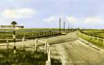 |
| ImageID: | SOS_011_001_001 | | Title: | The Strood, West Mersea, the road the Centurion guards !
From A Study of the Strood by W.E. Duane. Chapter 11. | | Date: | 1965 | | Source: | Mersea Museum |
|
 |
| ImageID: | SOS_011_002 | | Title: | A Study of the Strood by W.E. Duane. Chapter 11. Page 72.
Conclusion | | Date: | 1965 | | Source: | Mersea Museum |
|
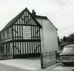 |
| ImageID: | SOS_011_003_001 | | Title: | The White Hart, West Mersea, venue of the annual audit dinner of the Church and Strood Lands Charity
From A Study of the Strood by W.E. Duane. Chapter 11. | | Date: | 1965 | | Source: | Mersea Museum |
|
 |
| ImageID: | SOS_011_004 | | Title: | A Study of the Strood by W.E. Duane. Chapter 11. 73.
Dinner Bill from the White Hart.
Names mentioned in the accounts: Mr Thomas May, Mr Bennett Hawes, Elizabeth Haward. | | Date: | 1965 | | Source: | Mersea Museum |
|
 |
| ImageID: | SOS_011_005 | | Title: | A Study of the Strood by W.E. Duane. Chapter 11. Page 74. | | Date: | 1965 | | Source: | Mersea Museum |
|
 |
| ImageID: | SOS_011_006 | | Title: | A Study of the Strood by W.E. Duane. Chapter 11. Page 75. | | Date: | 1965 | | Source: | Mersea Museum |
|
 |
| ImageID: | SOS_012_001 | | Title: | A Study of the Strood by W.E. Duane. Page 76.
Bibliography | | Date: | 1965 | | Source: | Mersea Museum |
|
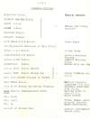 |
| ImageID: | SOS_013_001 | | Title: | A Study of the Strood by W.E. Duane. Page 77.
Original sources. | | Date: | 1965 | | Source: | Mersea Museum |
|
 |
| ImageID: | SOS_014_001 | | Title: | A Study of the Strood by W.E. Duane. Page 78. Appendix.
The Customary of West Mersea, Fingringhoe and Pete Hall Manors. | | Date: | 1965 | | Source: | Mersea Museum |
|
 |
| ImageID: | SOS_014_002 | | Title: | A Study of the Strood by W.E. Duane. Page 79. Appendix.
The Customary of West Mersea, Fingringhoe and Pete Hall Manors. | | Date: | 1965 | | Source: | Mersea Museum |
|
 |
| ImageID: | SOS_014_003 | | Title: | A Study of the Strood by W.E. Duane. Page 80. Appendix.
The Customary of West Mersea, Fingringhoe and Pete Hall Manors. | | Date: | 1965 | | Source: | Mersea Museum |
|
 |
| ImageID: | SOS_014_004 | | Title: | A Study of the Strood by W.E. Duane. Page 81. Appendix.
The Customary of West Mersea, Fingringhoe and Pete Hall Manors. | | Date: | 1965 | | Source: | Mersea Museum |
|
 |
| ImageID: | SOS_014_005 | | Title: | A Study of the Strood by W.E. Duane. Page 82. Appendix.
The Customary of West Mersea, Fingringhoe and Pete Hall Manors. | | Date: | 1965 | | Source: | Mersea Museum |
|
 |
| ImageID: | SOS_014_006 | | Title: | A Study of the Strood by W.E. Duane. Page 83. Appendix.
The Customary of West Mersea, Fingringhoe and Pete Hall Manors. | | Date: | 1965 | | Source: | Mersea Museum |
|
 |
| ImageID: | SOS_014_007 | | Title: | A Study of the Strood by W.E. Duane.
Stewards of the Manor of west Mersea.
Thomas Bonham. Died London 1532.
Thomas Cammock 1542 - 1602. | | Date: | 1965 | | Source: | Mersea Museum |
|
 |
| ImageID: | SOS_014_008 | | Title: | A Study of the Strood by W.E. Duane.
Stewards of the Manor of west Mersea.
Thomas May c1764 - 1843 Lord of the Manor of West Mersea c1800 - 1843 | | Date: | 1965 | | Source: | Mersea Museum |
|
 |
| ImageID: | SOS_014_009 | | Title: | A Study of the Strood by W.E. Duane.
Edmund King of England 940 946. | | Date: | 1965 | | Source: | Mersea Museum |
|
 |
| ImageID: | SOS_015_001 | | Title: | A Study of the Strood by W.E. Duane.
Some comments by Hervey Benham page 1. | | Date: | January 1982 | | Source: | Mersea Museum |
|
 |
| ImageID: | SOS_015_002 | | Title: | A Study of the Strood by W.E. Duane.
Some comments by Hervey Benham, page 2 | | Date: | January 1982 | | Source: | Mersea Museum |
|
 |
| ImageID: | SOS_015_003 | | Title: | A Study of the Strood by W.E. Duane.
Notes on the work, with a view to publishing it - by someone at Mersea Museum, referring to Ralph and Susan Luckham. | | Date: | 21 May 1982 | | Source: | Mersea Museum |
|
 |
| ImageID: | SOS_016_001 | | Title: | A Study of the Strood by W.E. Duane.
The Saxon Strood to Mersea Island by Julian Whybra B.A.(Hons) | | Source: | Mersea Museum |
|
 |
| ImageID: | SOS_016_002 | | Title: | A Study of the Strood by W.E. Duane.
The Saxon Strood to Mersea Island by Julian Whybra B.A.(Hons)
Chart showing variations in sea level over the centuries. | | Source: | Mersea Museum |
|