Wigborough Farms, Houses, Crofts
and Tenements 1595 to 1940

Reproduced with kind permission of James Pullen - West Mersea
Great Wigborough boundaries have changed quite significantly over the last three centuries.
In addition to this many of the property names have been altered over the same period of time, some more than once. Some properties no longer exist.
As a consequence of this it is often difficult to trace property and land in deeds and documents which refer to these old names or to understand where they were located.
In addition to recording historic Wigborough properties this document also records some of those properties/lands that have had name changes or have disappeared from modern maps but which have been positively identified through research.
It should be noted that the field numbers associated with the holdings have fluctuated over the wide period of time recorded therefore individual field ownership has not been shown.
In all instances every attempt at accuracy has been made however it is conceded that, as with all research, new evidence may come to light which alters some of the recorded facts.
The properties listed start from Peldon/Little Wigborough boundaries following the main road into Great Wigborough and then turn up School Lane, at the top after turning right to cover both Billets and Burnt House Farms on the Layer Road it returns to the bottom of School Lane and bears right towards Salcott cum Virley.
At the T junction by the Kings Head former Public House it turns right to the top of Middle Hill and then descends again to the Kings Head junction where it bears right to Salcott Cum Virley and onwards along this road to the Salcott Crossroads, again turning right. Those properties listed after The Kings Head are no longer within the current Great Wigborough boundary but details of these properties in the 1830 survey are given as they were recorded at that time in Great Wigborough.
The listings give the names in 2020, followed by other recorded names for the same property/farm as they appeared on researched documentation through the centuries.
The sizes of individual holdings are given as per the records in the measurement of the day, namely Acres, Roods and Perches. There being 40 perches to a rood and 4 roods to an acre.
The standard area measure in the Imperial system was the acre, which was divided into roods and perches. Area measurements were often abbreviated using the letters a.r.p.
The acre was defined officially as being 1 furlong (40 poles = 660 feet) in length, and 4 poles (66 feet) in breadth. The rectangular shape of this measure came about because arable fields were made up of long strips of land, each containing furrows running lengthwise. One 'furrow long' = 1 furlong
NOTE: All references to ERO are an abbreviation of Essex Record Office at Chelmsford where much of the research for this work was carried out and to whom I am indebted for their kind assistance and generous agreement to my usage of certain maps and drawings within this project.
A copy of the 1589 map of The Manor of Great Wigborough referred to throughout this work Reproduced by courtesy of the Essex
Record Office reference C32 AMS 69 is copied at the end, together with a partial copy of the 1881 great Wigborough Map
(Reproduced with the permission of the National Library of Scotland maps.nls.uk)
These maps show some of the farms and their names in 1589 together with their fields coloured in to give an indication of how that part of Great Wigborough appeared when transferred onto an 1881 Map.
Due to the differences in scale etc accuracy is slightly distorted.
As field boundaries have changed so much in the last 140 years no attempt has been made to make any comparison between 1589 and 2020. It is clear however that many small fields had the hedges grubbed out in order to allow bigger machines to work in much larger field areas as farming practises changed from labour intensive enterprises into machine dominated businesses.
Peldon Lodge / Billett's Barn
First ref: 1589 as below:-
Rev Llewellyn Christopher Watson Bullock BA in his booklet of Historical Notes on The Wigboroughs held at ERO says that Agnes formerly the wife of Alleyne & Edward Creafeld held the moiety of a cottage + garden called "Billetts" in Wigborough rent 1d. His source information is from a survey taken 26 Aug 31 Eliz (1589) of the possessions of Philip Earl of Arundel convicted of High Treason. He quotes "Exchequer L.R. Nuse? Books vol 214 J. 198-208."
NB Here it should be noted that the above work by Rev Bullock quotes several properties and their rental tenants and/or fees however some are not included in this work because the names of those places could not be verified against the known named properties contained herein.
In 1833 this holding comprised 25 acres 1 rood 7 perches, owner Sarah Quincey, tenant Mr Stephen Harvey. These fields comprised nos 215, 215a to 215e and were all attached to Billett's Barn, they lay adjacent to field 216 which was part of Seaborough Farm below.
In 1930 the owner and occupier was Mr P Golding however it is noted that on 12/2/1928 this holding was described as partly in "Layer or Peldon Parish."
See also Billett's entry listed later in this document.
Seaborough, Seaboros, Seabrows, Seabarrowes
In the 1595 Manor of Great Wigborough plan Seabarrowes was a holding of 58a 2r 28p.
P.H. Reaney - Place names of Essex, suggests it is probably associated with John Saburgh (1327 SR) and also gives a reference
of Saybarowes 1588 Rental. This is likely to be the Copyhold rental charges for the Manor. ERO holds copies of most of these.
In 1833 the farm holding was 132 acres 3 roods 20 perches, owner Rev'd J Papillon, tenant Will Runnicles.
The fields were roughly divided in half between Great Wigborough and Little Wigborough.
At that time Seabrows butted onto Peldon Lodge in the North, Bumsteads (currently Kestons) in the South, and Mulshams in the West.
Essex Record Office - Sale documents, show Seaborows and Moulshams Farms plus 4 labourer's cottages and 328a 1r 36p being sold by Messrs George Coote & Son on 17 July 1888 at The Mart Tokenhouse Yard, London. The sale was to be held at 2 o'clock precisely, in ONE LOT.
A newspaper report of 17/6/1898 Chelmsford Chronicle records Mr John Harrison, coroner, held an inquest at Seaborough's Farm
into the death of William Brown a labourer who was 75 yrs old and had been found hanging from a beam in his house by a piece of
leather. It seems that he had been much troubled by having to go into the workhouse. This would have been Lexden Union workhouse as the Wigborough Workhouse had closed in the 1830's.
A verdict of 'Suicide while temporarily insane' was recorded.
William actually lived in a property very close to Seaborough House as it is listed in the 1881 census straight after Seaborough House. He lived with his daughter Alice, her husband Charles Clarke head of house, son George W Brown, all three men are farm labourers. Other occupants were the five children of Charles and Alice.
In 1910 the Land Tax records show Seaboros with 102 acres owned by S W Blythe of Regents Park.
Mr Blythe had bought Seaboros from Mr Arnold in 1902 according to Mrs P.A.F. Stephenson's book "The Parish Registers of Great and Little Wigborough" 1905.
Mr Blythe also owned other land in Great Wigborough (Abbots Wick, Motts Field, Great Paynes. Fields 126 and 128 near the Kings Head which had belonged to Mulshams were purchased by him on 16 March 1910.)
1918 polling register held at ERO ref: C/E/2/2/1 lists William Horten as the owner with his abode being 16 Crediton Hill, West Hampstead.
However it lists Seaboroughs Farm as belonging to Ernest Walker whose abode is Haxels, Peldon.
In 1930 the occupier was Mr C.G. Wilkinson.

Seabrows
Reproduced by courtesy of the Essex Record Office reference C32 AMS 69.
Kestons, Bundy's, Bumsteads, Hinckley's in 16C
In the 1595 Manor of Great Wigborough plan, Hinckleys only has 26 acres.
Documents dated 1649-1703 - Wigborough Deeds of small properties (ERO D/DR T53 mostly in Latin) cites Bumsteads and Herstons? (possibly Kestons?) also Sherwyns all transferring from Bullock to Lymyne?
In 1833 this farm comprised 41 acres 3 roods 10 perches, owner Margaret Cline, tenant Thomas Creek.
The 1844 Tithe Map shows J.P. Osborne as the tenant of Margaret Cline the owner, however it is unlikely that he was farming this land himself rather that it was another business interest - see below

Bumsteads Farm
Reproduced by courtesy of the Essex Record Office reference C32 AMS 69.
John Posford Osborne b.31 Aug 1793, bap.3 Oct 1793 at Great Wigborough, died in 1863 aged 70, a memorial tablet can be found in
St Giles Church, Colchester.
Lexden History website gives full details of this very successful businessman, in 1833 he bought at auction the substantial Bawtree's Brewery holdings in St Botolph's and Stanwell Street, including a brew house, stores, residences, etc, as well as 35 inns and public houses. The brewery was soon producing more than 4,000 barrels a year. The boundary of the brewery became what we now know as Osborne Street but it had originally been used for horse-drawn traffic as a cut through from the Hythe to St John's Street. He also had shares in the Colchester, Stour Valley, Sudbury and Halstead railway company.
The fields for Bumsteads were to be found on both sides of the main Peldon/Wigborough road in 1833, fields 234 and 235 both being on the South side, these were later to belong to Alefounders below.
Coopers, Alefounders, Waylands, had incorporated several smaller holdings that were in existence and known variously as
Sherbins, Clerks, Hawkins and Gabels.
In the 1595 Manor of Great Wigborough plan the following acreages are given, see coloured map for locations
Gabels 16a 2r 19p, Sherbins 34a 1r 19p, Clerks 16a 0r 24p, Hawkins 21a 1r 20p
In 1833 (Coopers) comprised 79a 3r 9p, owner Charles Cooper had changed the name from Alefounders to Coopers. It was put it up for auction on 12 Sept 1838 where it realised £84.00.
In 1930 the owner/occupier was Edward Hutley born in Great Wigborough 1886, d. West Mersea 1967. The house was used as a labourer's cottage. Edward had farmed with his father Charles who died on 24 Oct 1927 aged 86 years, Charles had farmed at Wigborough for 67 years. They also owned and lived at Brickhouse Farm, below.

Alefounders
Reproduced by courtesy of the Essex Record Office reference C32 AMS 69
At the present time the farmhouse has for many years been used as a tractor and storage building and a farm workers bungalow built some 50 years ago near the farmhouse is the main residence. In October 2022 the whole farm was put up for sale upon the death of the owner occupier Mr Martin.
Chestnuts, Brickhouse Farm, Warestock House, Gales, Sharpes, Maitfield 16C
First ref: The Will of Henry Bullock 1578 National Archive PROB 11/61/174
[ For transcription see MARG_145 ]
"Item I give and be-
queathe unto Henrie Bullocke my sonne at his age of twentie one yeares and to his heires for ev[er]. All
my Customarie houses Landes and ten[emen]tes scituate lienge and beinge in the parishe of muche wigborowe
aforesaid called or knowen by the name or names of Rowses, Gales ten[emen]te/ Marshe house, Sharpes, widowes
Crofte, Warestocke house with a garden, a percell of Land called greate grove, twoe Croftes called Lymittes.
Galles house with an acre of grounde twoe croftes of land called matefeilds and a crofte called Dods Crofte
or by what soev[er] other name or names all my lands lienge and beinge in the parishe of wigborowe be called or
knowen withall and singuler theire appurt[en]unces
Rev Llewellyn Christopher Watson Bullock BA in his booklet of Historical Notes on The Wigboroughs written circa 1930 is held at ERO.
His source information is from a survey taken 26 Aug 31 Eliz (1589) of the possessions of Philip Earl of Arundel convicted of High Treason. He quotes "Exchequer L.R. Nuse? Books vol 214 J. 198-208."
He says Richard Wiseman held a tenement & lands "Rowses Hietts", a tenement called Sharpes, 2 crofts called Lynnets Crofts, tenement called Gales, Marshe House and Warestocke House, a croft called Widdowes Croftes, 2 crofts called Maitfields, a croft called Dodes Crofte and a parcel of land called the Great Grove. The total rental for these properties was 47s 7d.
The 1595 plan of the Manor of Great Wigborough shows Gales and Maitfields with 33a 2r 8p however there is also a holding listed under Warestock and Gales comprising 68a 2r 28 p. see coloured map for locations. The only properties shown with these holdings are on the South side of the road, with no building showing at or near the present day location of Brickhouse Farm/Chestnuts. HOWEVER see Rainbow Field below where deeds appear to indicate that a property known as Mazengarbs was located at that time on the site of the current Brickhouse Farm/Chestnuts.
ERO D/DU 422 (1596) (see Lynetts Croft below for full transcription)
"Also one Tenement called Sharpis \Sharps/ alias
Gales conteyning xl acres customary and heriotable
by the yearely rent of xj s viij d"
ERO records also hold the following:-
1644 Tithe records D/DU 4/16 showing William Theedum and his wife owning "a tenement called Sharpes, late Henry Bullocke's. The same for Rowses, Marshe House, 2 croftes of pasture called Lynetts, a piece of pasture called Brooms Grove, the same for a tenement and diverse lands in Wigborowe. The woods and timber trees on the two last mentioned coppie holds are to be surveyed and valued."
Will of William Theedum 1676 who was the owner of Rouses, his son William was resident in Rouses at his fathers date of death and he inherited many of the other properties however Sharpes was inherited by William Theedum Snrs daughter "Christian" in this Will and thus it was broken away from the other properties.
In 1769 "Abbes Hall Manor Rentall" for Gales was 2 heriots charged as 11s 8d. The owner and occupier was Thos Sams.

Gales
Reproduced by courtesy of the Essex Record Office reference C32 AMS 69.
In 1833 (Called Gales) this comprised 120a 1r 20p, owner occupier stated as George Clarke, however this acreage included
Staffords, a small farm holding comprising 17a 3r 30p at the north western end of School Lane. See below for Staffords records.
The Essex County Standard carried an advertisement notice on 9 April 1841 for a Miss M. A. Harvey to her Friends and the Public that due to increased patronage she was removing her Preparatory Seminary from Peldon to The Brickhouse in Great Wigborough where the Building and Grounds were on a more commodious scale. She then promises to offer assiduous care and attention to her pupils whilst not forgetting the domestic comforts that children must necessarily require. This suggests that Miss Harvey may have been renting the farmhouse premises for herself and her school.
By 27 Feb 1846 she is practising in West Mersea at another property also called Brick House, again advertising in the ECS Newspaper.
The 1844 Tithe Map shows William Hutley is the occupier of Abbotts Hall which is owned by Margaret Cline, however William Hutley is also shown as owner and occupier of Gales (Brickhouse) and Alefounders/Waylands (now Coopers) but his tenant at Staffords is Samuel Alen.
William
There were two farm related accidents reported that occurred during their tenure of the above farms.
11 Jan 1878 Essex County Standard John Howard aged 14, the son of a Wigborough labourer was accidentally shot by Thomas Osborne aged 12 years who was the son of James Osborne, employed by Charles Hutley as a labourer on the farm.
The boys were looking for rats through a hole in the mangold house wall that went through to the pigs' sty.
It seems the gun was loaded with shot for rook shooting by James Osborne who had left it propped up in a corner of the dark outhouse. The boys were friends and somehow it seems the gun had caught against Thomas's leather breeches and gone off, firing upwards at an angle that hit John in the lower part of his body. Mr Hart a surgeon was summoned but despite his best efforts John died the same evening.
Verdict "Accidental Death."
22 August 1886 Essex County Standard Sad Death from Poisoning.
Joseph Mouling aged 56, a labourer from Wigborough employed by Charles Hutley was at work on 13th August 1885 went to the knife house to grind his scythe, he was thirsty and lifted and drank from a half gallon stone bottle which contained poison called "sheep dip." He was violently sick and was taken to Dr Salters at Tolleshunt D'Arcy, but the remedies were all too late to save him and he died about midnight on the Sunday. Verdict "Accidental Death".
On 31 March 1922 the Chelmsford Chronicle reported on a Disputed Farm Sale. An action had been brought in the Chancery Division by Mr William R Hunt of Lower Moulshams Farm, against Mr Charles Hutley of Brickhouse Farm Wigborough, to recover damages for alleged breach of Agreement to sell him Moulshams Lower Farm. Mr Hutley said that he had never received any proposal by Mr Hunt to exercise his option to purchase the farm. The action was dismissed with costs to be paid by Mr Hunt.
Edward Hutley had farmed with his father Charles who died on 24 Oct 1927 aged 86 years, Charles had farmed at Wigborough for 67 years. They also owned Coopers Farm, above.
When Charles Hutley died the farms were offered for sale by Auction through Fenn Wright & Co on Saturday July 13th 1929.
Edward was unmarried and resident at Brickhouse Farm in the 1939 census records, he is recorded by Rev L.C. Bullock in his 1930 survey as being the owner.
In 1930 the owner/occupier of both holdings was Mr Edward Hutley and it was called "Brickhouse Farm" or "The Chestnuts". This
is recorded in such a way as to indicate that it was known by both names at this time. It is probable that this dual name
resulted from the fact that the original house was so badly damaged in the 1884 earthquake that it had to be re-built.
(for further information see Elaine Barker - Brick house Farm alias Chestnuts .
Rainbow Field
Ref ERO: D/DEL T375 contains several documents which evidence the following transactions.
25 March 1817 Henry Cline sold Rainbow Field to Rev'd Edward Peter for £150 including the properties and outbuildings.
In 1833 this comprised a holding of 2a 3r 29p and was occupied by John Basket.
The field numbers were 196 Rainbow Field and 196a Cottage and garden.
In 1835 an Indenture cites Jenny Peter, widow of Rev'd Edward Peter' and Edward Page to Thomas Creek for the sum of Five shillings rental for a year and thereafter a peppercorn rent. It confirms that the land was previously part of Hill Farm etc.
All of these documents give details of the location of Rainbow Field and state that it is:-
"situate in Great Wigborough formerly part and parcel of a certain farm or estate called the Hill Farm heretofore belonging to Samuel Bullock deceased and abutting towards the North and West on the Glebe lands of the Rectory of Great Wigborrow aforesaid and towards the South and East on certain lands heretofore of Thomas Davis called Muzongarbs (or Mazengarbs) as the said piece or parcel of land was of late in the occupation of Edward Peter and now is in the tenure or occupation of the said Thomas Creek his undertenants or assigns"
This location infers that the property now known as Chestnuts or Brickhouse Farm in Great Wigborough may have been called Mazengarbs previously. Further proof is needed to confirm this fact though.
June 8th 1868 at an Auction Sale at The Cups Hotel in Colchester properties late belonging to Mrs Elizabeth Creek dec'd comprising a house and garden, an enclosure of land adjoining known as Rainbow Field and two cottages with gardens realised the sum of £355. It was bought by Rev'd Frederick Watson of Messing.
This holding was all in the occupation of Mr Drake who owned certain sheds upon the site these could be removed or sold at valuation to the purchaser.
From that time to the present day the corner junction has been known as Drakes Corner.

In the 1970's the Victorian brick house seen above on the left between trees c1905 has now been demolished and replaced by two new houses on part of the land, this original property was braced with an iron cross and straps to tie the brickwork together as it had been damaged in the 1884 Earthquake. Mrs Coppin was the owner/occupier during the 1970's/1980's..
Mulsham, Moulsham
Essex Place Names Project
(Essex Society for Archaeology & History), 2013 Records give more detail
There were these manors: 1. Abbess (alias Abbot) Hall was held by the abbess of Barking Abbey. In 1540 it was granted
to Thomas Cromwell, and in 1545 to Charles Tuke for 1/40th of a knight's fee. 2. Mulsham, t.Edward Confessor by Aelfric, was held by William de Mulsham. Of the Honour of Castle Hedingham, Walter de Pattishull held it in 1351. Part belonged to Sir John Peake, Lord Mayor of London in 1687 (Morant, 1768).
The Bullock family owned and partly resided at Moulsham for nearly 200 years during the 16th, 17th and 18th Centuries.
In 1833 Mulsham comprised 232a 3r 30p and was owned and occupied by Peter Wright of Hatfield Priory. The land contained some 25 fields which were split roughly over 3 different blocks in Great Wigborough. The main block being near the Church, another sizeable holding was near the Kings Head known as Lower Mulsham and two further fields opposite Abbots Hall. The main "Homestead and Property" lay to the East of the Church with a cottage and garden in the grounds close to the Church.

Mulsham
Reproduced by courtesy of the Essex Record Office reference C32 AMS 69.
This whole Farm was sold in 1859 and became split between 4 new owners. The Rev J Papillon bought the main block by the Church with the exception of field 186 stated as having 8a 1r 20p which lay to the north of the Church and the East of Hyde Farm. This field was sold to Rev Godfrey Bird, however by 1888 in the sale catalogue below it is shown as belonging to Rev'd F Theobald so it was probably "Church Land". This appears to be different from Glebe Land. NB See also WORKHOUSE property as below.
"Lower Mulsham" was bought by Mr S Blythe and fields 126 and 128 opposite the Kings Head were let to Mr C Sanders as his tenant. Fields 143 and 144 opposite Abbots Hall were purchased by Mr Daniel, the tenant was Wm Bonner.
A Sale catalogue shows that on Tuesday 17th July 1888 a "Compact Estate comprising Seaborows and Moulshams Farms with substantial Farm House and two sets of excellent Farm Premises, 4 labourers cottages and 328a 1r 36p was to be sold in one lot.
Interestingly the detailed catalogue states that "Moulshams Farm House has been converted into three labourer's cottages."
In 1907 it was described by Mrs Pamela Stephenson as having "fallen into decay, and what remains of it is partitioned into cottages and a farmhouse, with 130 acres of land, lately owned by Mr Oxenham. The numerous traces of foundations in the neighbourhood of the present house show that in former times it must have been a mansion of some importance".
Moulshams Farm was again sold at auction at the Corn Exchange, Colchester on Sat June 10th 1922 and described as comprising 130a 3r 8p of which 94 acres are grass and 36 arable together with a fine old oak beamed Farmhouse, good set of premises and a cottage.
Note that in 1922 Lower Moulshams owner, Mr Charles Hutley of Brickhouse Farm (see above records for Brickhouse Farm) was taken to court in Chancery by the tenant William R Hunt who had an option to purchase within a timescale. Hutley won the case stating that no such request to purchase had been received by him from Hunt. The case was dismissed with costs to be paid by Hunt.
In 1927 The Rev Watson Bullock attempted to discover why this old Manor House seemed to have lost its original status and provenance. He wrote to learned and connected colleagues within the upper echelons of the Clergy etc. The detailed correspondence is held at ERO in Chelmsford. The results regarding Moulshams loss of status was inconclusive, however there are several references to Latin Documents held in Ecclesiastical files and it would appear that the Essex Place Names Project was more successful in 2013 as stated above.
Glebe
In 1833 this comprised 96a 0r 35p and these numbers remained almost the same in the Terrier of 1890.
The fields were widely located across the whole of Great Wigborough boundary as it was then, including in Salcott cum Virley, Tolleshunt Knights and Tiptree.
With the exceptions of fields 190 (Rectory, yard, garden) 191 (Church Yard) 193 (Rectory Meadow) all were sold in 1918.
Great Wigborough Glebe lands were listed along with many others in a Sale Catalogue entitled "ESSEX Sale of Freehold Glebe Lands" by Auctioneers Messrs Beadel, Wood & Co, 97 Gresham Street, London, E.C.2.
Ref: ERO SALE/A83
This sale of Wigborough Glebe land was divided into 7 Lots one of which was in Little Wigborough.
The sales particulars gave the size of each enclosure included in the Lot number, some had names of persons the fields and/or properties were let to, and when or if they had been given notice to quit at Michaelmas 1918 or 1919. In some lots the residents of a property had occupancy rights for their lifetime as was often the custom with long serving farm workers and their widows. There were also Annual rental charge details and Rectorial Tithe charges where applicable.
Plans for each lot were attached to the particulars however the field numbers given were for the benefit of the sales particulars and do not always correspond with any of the maps of the period. Identification was made by studying the plan that accompanied the particulars of sale.
Little Wigborough
Two old cottages and gardens and 22 acres 0 roods 5 poles namely
Part field No 34 Arable,
Field nos 47 Arable, 45 cottages and garden, 46 Pasture
Names listed on some of the lots that were let out included:-
Sir Anthony Abdy, Mr Arthur Foakes, Mr Arthur Rogers, Mr James Balls,.
The Little Wigborough Small Holding is 22a 0r 5p where the land is let to Mr John Wright with notice to quit at Michaelmas 1918. Widow Fenn occupies one cottage on a life tenancy, the other cottage is let to Mr O Fenn.
Some of the named Great Wigborough Glebe Lands sold were:-
Glebes, Mearns, Sigramead, Bridge Meadow, Great Anticroft, Church Field, Gutter Field, Little Anticroft, Lower Hill.
There were two small areas of wood, one in Tiptree (see Gobolts below), the other adjacent to the Great Wigborough school site that had already been conveyed in the late 1800's. This field, no 152, was known as Bridge Field and had formerly been a part of a much larger holding known as Lynetts Croft, see further below.
Field 138 near to the old Workhouse was described as "An Enclosure of Garden Land", it was let to various tenants as allotments at a rent of £3 per anum, no names are given.
Lot 29 in the sale was not Glebe land, being described as two freehold cottages of timber and slate situate on the Mersea Road in Great Wigborough containing an area of about 30 poles Let to Mr J D Walker, Mr Jabez Wenlock. The location was described as part field 81 on the Ordnance Survey map of 1897. This appears to have been situated behind a property known today as Bucklands. It is probable that these cottages may no longer exist or may be ruinous. Google Earth shows potential collapsed remains as at 2022.

Glebe
Reproduced by courtesy of the Essex Record Office reference C32 AMS 69.
Sigramead - Glebe
This is field no. 145 on both Tithe and County maps, it lies to the West of Rowsers Farm in the Terrier map of 1890 comprising 16a 0r 10p. It was sold in 1918 along with all other Glebe lands in Wigborough (see Glebe Land above)
Hyde Farm, Hiddes
A plan dated 1595 of the Manor of Great Wigborough shows it as copyhold of this Manor and known as Hiddes comprising some 111a 3 r 36 p.
ERO has a photograph of a map drawn in 1732 by Joseph Kendall, which says it is an exact survey of lands called Hide lying in Much Wigborough belonging to Capt. Kilham containing 118a 3r 32p. Kendall notes 'I allow more for road and waste 6a 0r 8p'. The map gives each field drawn to scale with the field sizes and names, e.g. Parrocks, Gander Field, Great Doddens, Great Anticroft etc. School Lane is named as 'Lane to Much Wigborough'.
This map was copied with updates in 1928 and a copy given to Rev L C Watson Bullock by Mr Welham.
In 1833 Hyde Farm comprised 130a 3r 30p the tenant was Robert Wesney Jnr who was a Church Warden, the owner was Sir W Marsh, he sold Hyde Farm in 1869. On the 1844 tithe map the owner is stated as Anna Maria Marsh with the tenant still Rob't Wesney who also farmed Hill Farm opposite.
Rob't Wesney Jnr was the owner of a field and property known as Willow Field (no's 136 & 137) 7a 3r 35p. This was situated at the far end of Church Lane (now known as Green Lane) on the right (Northern) side just before it ends by abutting onto the main road known then as Middle Hill, near Lower Moulshams Farm. The property no longer exists, it stood fronting the lane looking South and was opposite a large house known to be The Workhouse up to 1830 which belonged to the Church. Although Robert Wesney owned Willow Field and the cottage he had let the cottage out to Messrs Rice and Salmon.

Hyde Farm
Reproduced by courtesy of the Essex Record Office reference C32 AMS 69.
1918 polling register held at ERO ref: C/E/2/2/1 lists William Thomas Brown as the owner occupier.
In 1930 The Hyde was owned by Mr G Welburn and Mrs Nora Forbes who were the occupiers along with Mr C D Forbes.
Staffords
In 1595 the Staffords holding comprised two fields under separate copyhold ownerships of Hiddes, known today as The Hyde, and Hethouse or Helhouse which is today known as Hill Farm.
In 1833 this was a small farm holding comprising four fields, nos 174 to 177, totalling 17a 3r 30p at the northern end of School Lane. It shows on maps as Staffords Cottages drawn on the right hand side at the approach to the main road to Layer de la Haye. The cottages are central to three fields, nos 175/6/7 on the right-hand side of School Lane with a further field, no 174, on the left hand corner opposite.
It was owned and occupied by Geo Clarke who also owned Chestnuts/Brickhouse Farm at that time.
The 1844 Tithe awards show William Hutley as the owner with Samuel Alen as the tenant.

Staffords
Reproduced by courtesy of the Essex Record Office reference C32 AMS 69.
By 1930 it is not clear what has happened to this holding, it probably still belonged to Edward Hutley along with Brickhouse and Coopers above however the properties on the holding may have been demolished or are uninhabited. Local memory as at 2021 holds no knowledge of properties at this location from the mid 1940's. Certainly, by the 1970's there was no building/house/cottage on that side of the lane.
On 15th February 1944 there is a record at ERO of a Camouflet, or artificial cavern, created when an unexploded bomb fell on land at Staffords Corner, it was disposed of at 11am on 11th March 1944 Ref: C/W 1/7/17 at ERO Chelmsford. Opposite this field on the main road leading to Layer stood a bungalow that was occupied by a Miss Argent according to current local resident Tony Buckle who says it was pulled down and replaced by the current house known as Blairgowrie.
Billets
This was not included in the Survey of 1833 as part of Great Wigborough, however it is included in the Manor of Abbeshall in Wigborough in a survey taken on 26th August 1589 of the possessions of Philip Earl of Arundel convicted of high treason, where it is described as Billettes a cottage and garden - rent 1d. See more detailed information in Billets Barn at the beginning of this document.
Billetts is also to be found on old maps of that era located down a long drive leading off the right hand side of the road from Staffords Corner to Layer de la Haye. Notes indicate that this area became part of Layer de la Haye in 1888.
NB More information on Billets Barn and Burnt Downs Farm below can be found on Mersea Museum website under the title
"Abberton Reservoir - what was there before?" by Elaine Barker .
Burnt Downs Farm, Aldenham Oak Farm
As previously for Billets Farm regarding the Survey of 1833 however the location of this farm was on the left hand side of the road from Great Wigborough leading to Layer de la Haye and just before the trackway on the right that led down to Billett's Barn.
There is no trace of this farm now, the land on which it stood floods with any heavy rainfall forming a large pond or lake. The original plan of the Abberton reservoir expansion scheme in 2013 was to stock this lake with fish but it was dropped when it became apparent that it dried out completely in the hotter summer months.
Essex County Standard (ECS) 15 Nov 1849 records "the death of Mr James Fosdyke formerly for many years the occupier of Burnt Downs Farm."
ECS 15 Nov 1884 records Under Distress for Rent the Auction sale of all live and dead farming stock, implements etc to be sold by Sexton & Grimwade on Tes 18 Nov 1884 upon the premises.
ECS 22 Sept 1888 Auction to be held at 1 O Clock at Burnt Downs Farm of the Live and Dead Stock, 3 cart horses, 6 grazing beasts, 6 head of swine, all agricultural implements, harness etc "the farm having been let"
Norfolk Chronicle 17 March 1906 Aldenham Oak Farm 80 acres and 8 room house plus 2 cottages for Auction by Messrs Rutter of 10 Norfolk Street, Strand.
Chelmsford Chronicle advertises on 13 Sept 1918 for sale by Auction through Thos D Brook on Weds 18 Sept all farm stock & implements etc by order of Mr GB Hammond, who has sold the farm.
The last newspaper account that mentioned this farm during this research period was the report in 1939 of the marriage of James Maurice Eade of Tolleshunt Knights who is "the son of the late Mr Eade of Aldenham Oak Farm."
Workhouse
In Workhouse Lane, later known as Church Lane, now in 2022 known as Green Lane, this property has gone without trace 2021. There
were no visible remains in 1970,
In 1833 this comprised 11a 1r 15p and was described as Church Land. There was a large house on the land which had
been used as a <>Workhouse and stood on field 131, field 130 was an arable field. The whole was occupied by John Chignell in 1833.
An advertisement in the Chelmsford Chronicle on Fri 1st Sept 1837 offered "To Be Let By Tender with possession at Michaelmas Next" Church Land "with a large house formerly used as a workhouse." Interested parties were to apply for particulars to Mr R Wesney, Churchwarden, of Great Wigborough. He asked for tenders to be sent to him by Saturday 16th September next.
In the 1844 Tithe records William Wheeler was the occupier.
In the 1891 Census there are 3 properties housing a total of 7 persons all living in Workhouse Lane and a further 2 properties listed as being uninhabited.
Field 138 was situated near the workhouse and workhouse field, but this was Glebe Land and was sold in the 1918 sale of many Glebe Lands recorded previously. It was listed as Lot 28 with 1a 3r 4p.
See map under entry for Glebe for location.
In 1927 the Rev Watson Bullock in his Survey Update wrongly suggests it is now included with workhouse field. It was not and had been sold away. It was described in the sale brochure as an enclosure of garden ground let to various tenants on yearly Michaelmas tenancies.
In 1934 Church Minute records indicate that this old workhouse area was rented out to P. Christmas (from the Kings Head) for the sum of £5 a year for shooting rights.
Welhouse, Hethouse, Helhouse, Hill House Farm, Hill Farm,
The 1595 Manor of Wigborough plan evidences this farm as being called Helhouse comprising three separate fields with a combined acreage of 50a 0r 26p.
ERO records contain hand written notes by Rev L.C.W. Bullock in which he states John Bullocke held a tenement and lands
called "Welhouse", alias "Helhouse" rent 10s.
The Ipswich journal 01 Dec 1810 contains an article described as Farming Stock, Household Furniture &c, Hill House Farm, Near Wigborough Church. The farm had belonged to Samuel Bullock Jnr deceased.
They were to be sold by Auction by W Jackson on Thurs 6th Dec 1810.
It included all furniture and farming stock, dairy and brewing utensils. 3 cart horses, two 3yr old fillies, quiet in harness and fast trotters, 2 very good waggons, 3 young milch cows, 7 strong shoats, tumbrels, plough and cart harnesses etc. Good featherbeds, mattresses, counterpanes, tent and 4 post bedsteads, mahogany and chamber chairs, three very capital guns, brace of good pistols sweet seasoned beer casks, stoves, ranges, dairy articles, etc
In 1833 it was known as Hill Farm, had 114a 1r 5p and was owned by Margaret Cline, the occupier was Robert Wesney.
The main block of fields surrounded the homestead, however there were three further fields on the South side of the main
Wigborough road, these were facing Rowses Farm fields, and a further field (no. 141) lay just before the Kings Head junction, facing the main Wigborough road.
A plan of the farm held at ERO dated 1815 gives the acreage as 140a 1r 20p, this appears to be partly due to variances in the quoted acreages for some fields and partly to land being included which was later marked on Ordnance survey maps as belonging to Little Wigborough.

Hill Farm
Reproduced by courtesy of the Essex Record Office reference C32 AMS 69.
By 1888 it was all included in Great Wigborough and was occupied by William Abbott, census returns for 1881 show "Seed Grower & Farmer 145 Acres Employing 10 Men 4 Boys", however the ownership at this point is unclear.
In 1930 the owner and occupier was Mrs E Williams and the acreage was unchanged from that shown above in 1833.
Lynetts Croft, Linnets Croft
Linnets Croft is listed as a Copyhold holding on the plan dated 1595 of the Manor of Great Wigborough. At that time it comprised an oblong shaped block of land of 56a 3r 35p. The boundaries ran from the southern end of School Lane up to the track that leads to Hill Farm then followed that track in a westerly direction down to the present-day Hill Farm house where it turned south down to the present lay-by opposite the entrance to Abbots Hall. Thus, it encompassed the whole of the current Rowses Farm, Rowses Hill House and part of Hillside Dairy Farm. There is a property shown on the map in the same location as Rowses Farm, however deeds, Wills and other records around that date and going back to 1266 do not have maps attached to clarify the ownership of either at that date.
Whilst the name Lynetts Croft appears on several documents in the ERO they are in Latin and have not been transcribed.
First ref: 1589 as below:-
Rev Llewellyn Christopher Watson Bullock BA in his booklet of Historical Notes on The Wigboroughs written circa 1930 is held at ERO. His source information is from a survey taken 26 Aug 31 Eliz (1589) of the possessions of Philip Earl of Arundel convicted of High Treason. He quotes "Exchequer L.R. Nuse? Books vol 214 J. 198-208."
He says Richard Wiseman held a tenement & lands "Rowses Hietts", a tenement called Sharpes, 2 crofts called Lynnets Crofts, tenements called Gales, a Marshe House and Warestocke House, a croft called Widdowes Croftes, 2 crofts called Maitfields, a croft called Dodes Crofte and a parcel of land called the Great Grove. The total rental for these properties was 47s 7d.
Of note Richard Wiseman has an inscription in St Stephens Church at Wigborough. It is a black floor slab " Here lyeth ye bodie / of RICHARD WISEMAN / who departed ys / world in November / 1616
Of particular interest are records that show the Bullock family as considerable land owners in Great Wigborough around 16C to 17C as follows. Many of the farms and holdings in this work are shown in the transcribed document below.
ERO D/DU 422 (1596) (Transcription by Elaine Barker, Peldon History project, from documents re the Bullock family).
(Many other Bullock family documents are recorded on www.merseamuseum.org.uk - see MARG )
| Henry Bullocke holdeth one capitall | |
| messuage and iiij xx acres and xxxviij perches | |
| of land medowe and pasture customary and he= | |
| riotable called Rowses by the yearely rent of | |
| xxix s Also one Tenement called Sharpis \Sharps/ alias | |
| Gales conteyning xl acres customary and heriotable | |
| by the yearely rent of xj s viij d Also one Tenem[en]t called | |
| Marshe House and xvj acres; xxxv perches of | |
| pasture and xvj acres of Salt marshe Customary & | |
| heriotable by the yearely rent of iij s iiij d Also | |
| one croft called Dowdes croft conteyning ij | |
| acres iij roodes ij perches by the yearely rent | |
| of ijd Also one Tenement customary and | |
| heriotable called Warestockehouse conteyning | } xlixs ijd |
| xxxj acres iij roodes and xx perches customary | v herriots |
| and heriotable by the yearely rent of xviijd Also | |
| ij croft[es] or pightells called Abbesgrove cont ij | |
| acres j rood xx perches by the yearely rent of | |
| iijs Two croft[es] of land called Lynnet[es] Croft[es] cont | |
| iij acres by the yearely rent of viijd Also one | |
| tenement called Gales house with an orchard & | |
| garden cont j acres j rood xx perches and ij | |
| crofts of land called Maitfield[es] cont iiij acres ij | |
| rood[es] xij perches customary and heriottable | |
| by the yearely rent of vs in toto | |
| The yearely value iiij xx x li | |
Later maps and the Tithe map of 1844 show it as a small holding on field nos 152 of 5a 2r 0p in arable use and no 153 comprising 2r 15p of woodland both owned by Rev Godfrey Bird and lying adjacent to fields then belonging to Rowses Farm. Part of this woodland area later became the grounds for the Great Wigborough Church of England School.
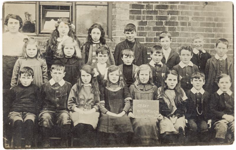
Image Courtesy Mersea Museum / Heather Haward Collection
Great Wigborough School was founded in 1854 and closed December 1932.
Great Wigborough School. Group 7. C.1910
Back row 1. Amy Talbot teacher, 2. Dorothy Christmas, 3. Joe Rout 4. Hedly Theobald, 5. Edd Christmas, 6. Harold ? Theobald, 7. Charles Douson
Middle row 1. Florry Fen, 2. Con Christmas, 3. Trevor Wilkins, 4. Greg Ponder, 5. Emm Goody, 6. George Matthews
Front row 1. Harold Ponder, 2. Peter Clarke, 3. Connie Douson 4. E. Christmas, 5. Beatrice Frances, 6. Ida Williams 7. Maurice Williams, 8. D. Christmas

The derelict school May 2020
Welhouse
Welhouse & Roweses (see next entry below) are listed as one Copyhold holding on the plan dated 1595 of the Manor of Great Wigborough. The acreage is 30a 1r 9p in total and it comprises one field on the southern side of the main through road in Great Wigborough abutting onto Abbot's Hall land. It is opposite Linnets Croft above.
There appears to be a property on the top right hand side of the land which is possibly the present day site of Brickhouse cottages.
No further deeds or maps have been traced that record Welhouse, however see the reference above under Hill Farm where it appears to have been an alias for Helhouse, now known as Hill Farm. It is possible that this field was under shared copyhold ownership with Rowses Farm so far as the Manorial Records of Great Wigborough were concerned at that time.
Rowses, Rouses, Rousers, Rowsers
See above entry.
The 1595 plan mentioned above shows no separate entry for Rowses Farmhouse, although there is a property shown on Linnetts Croft in the same location. There are deeds, plans, wills and other documentation that show it as a property, namely
1597 Henry Bullock's child buryed unbaptised from Rouses
ERO Land Tax records D/DU 4/21 show Henrye Bullocke owning 8 properties including Rouses which are chargeable as 5 heriotts.
St Stephen's Church in Great Wigborough records on a Stone floor slab. Here lyeth the body of / HENRY BULLOCKe the only / sonne of HENRY BULLOCKE / Muche Wigbrowghe whoe / departed this lyfe the / 4th day of November An / Domin: 1628 /
It is unclear which particular Henry Bullocke this is however.
ERO records also hold the following:-
1644 Tithe records D/DU 4/16 showing William Theedum and his wife owning a tenement called Sharpes, late Henry Bullocke's. The same for Rowses, Marshe House, 2 croftes of pasture called Lynetts, a piece of pasture called Brooms Grove, the same for a tenement and diverse lands in Wigborowe. The woods and timber trees on the two last mentioned coppie holds are to be surveyed and valued.
Will of William Theedum 1676 who was the owner of Rouses, his son William was resident in Rowses at his fathers date of death.
1722 Tithe rentals name Elizabeth Cross as the owner with William Willis as occupier
1769 Tithe rentals for Abbeshall the owner is Thomas Cross the occupier was John Bullock however this is crossed out and Widow prodatis written into the space above indicating that John Bullock has died.
1772 Rouses has several owners, Joseph, William and Elizabeth Cross, Mary Whyat and Robert Munson. The herriott is 7/= and the occupier is Martha Prentice.
Chapman and Andre Map of Essex 1777 and Ordnance Survey Map 1805.
P.H. Reaney in Place Names of Essex suggests Rowses is probably to be associated with the families of John and Robert le Ro(o) (1272 Ass, 1332 SR) SR being subsidy Rolls.
In 1833 Rowses comprised 8 fields on both sides of the Wigborough to Salcott main road totalling 42a 0r 19p.
The owner was the Rev'd Plume of Boxford and the tenant William Bonner who is shown on the Census records in 1841as the resident farmer.

Rowsers
Reproduced by courtesy of the Essex Record Office reference C32 AMS 69.
In 1851 William has 64 acres and 3 men, and in 1861 he has 55acres and 3 labourers.
In 1871 the census shows his son Matthew Bonner as the farmer with 115 acres 6 men and 2 boys
In 1881 Matthew is still there with 3 men and 2 boys but no acreage given.
Rowses was sold on 2 May 1883 by a Trustee with others of the Estate of the late Miss MM Cooper to Dr Hugh Green who lived in Strood Villa at Peldon/Mersea. He does not appear to have ever occupied Rowses Farm and rented it out to tenant farmers.
1891 Rowses has a new occupant, William Abbott born in Salcott, farmer and seed grower, who had been farming at Hill Farm in 1881with 145acres, 10 men and 4 boys.
In 1901 William Abbott has married his servant Alice Evans (Wigborough born) she is widowed and 8 years his junior with 3 children all of whom live with them, also Arthur William Abbott 4 yrs who is the son of William and Alice.
1911 William, Alice and Arthur are still at Rowses.
1923 the Dundee Evening Telegraph reported on 20th June 1923 that Mr William Abbot of Great Wigborough who had recently retired from farming at the age of 75 had left his house saying he was going to look at the crops. Later a farm worker found him dead in a field, he had been gored by a bull which was grazing in an adjoining meadow.
In the Parliamentary returns of 1927 the owner and occupier is William Henry Sherriff Shirley, he remained so in the 1930 Rev C W Bullock survey.
William Shirley had previously lived at Ransome's Farm in Peldon but moved to Wigborough after the death of his wife in c 1918.
1932 on 2 September The Chelmsford Chronicle recorded his sudden death at Rowses Farm at the age. of 87 years. He left two sons and three daughters.
Rowses Hill, Rowses Heitt, Daniells Cottage
First ref: 1589 as below:-
Rev Llewellyn Christopher Watson Bullock BA in his booklet of Historical Notes on The Wigboroughs written circa 1930, held at ERO. His source information is from a survey taken 26 Aug 31 Eliz (1589) of the possessions of Philip Earl of Arundel convicted of High Treason. He quotes "Exchequer L.R. Nuse? Books vol 214 J. 198-208."
He says Richard Wiseman held a tenement & lands "Rowses Hietts", a tenement called Sharpes, 2 crofts called Lynnets Crofts, tenements called Gales, a Marshe House and Warestocke House, a croft called Widdowes Croftes, 2 crofts called Maitfields, a croft called Dodes Crofte and a parcel of land called the Great Grove. The total rental for these properties was 47s 7d.
Lying to the West of Rowses and once part of Linnets Croft was a tenement positioned adjacent to the road with an undefined area of garden or land on all early references.
1675 occupiers Thomas J Eldred and J Milbank document signed by Baron Brykwood Snr, Ralph Creffield cites Wigborough Magna Rowses Hill and Lynnetts (all in latin)
1769 rental charges of Manor of Abbess Hall lists the owner of Sharpes as George Wayland and the occupiers as Wm Willis and Jesse Ward.
The 1833 survey does not reference this tenement or mention an owner or occupier, the plan of Rowsers shows it drawn and numbered as though it is part of Rowsers however the detailed farm field records do not list it.
The Tithe Award of 1844 and the County map of 1833 show it as field no 147 described as Cottage and garden. Thomas Daniel is the owner in 1844 and the occupiers are Samuel Legerton and John Nice, it comprises 15 perches.
1918 polling register held at ERO ref: C/E/2/2/1 lists George and Arthur William Theobald as the residents entitled to vote living at Daniells Cottage,
The 1930 survey which updated that of 1833 makes no reference to it but this is possibly because it was such a small unit at this time comprising only a small cottage fronting the roadway.
Current local resident, Dorothy Buckle who in 2022 resides in Lin-Gram, a bungalow built in the 1960's and a short distance from Daniel's Cottage actually remembers living in this property along with her widowed mother and 13 brothers and sisters as a child.
Abbots Hall, Abbess Hall
The English Place-Name Society gives the following etymology for Abbotts Hall.
Abbot's Hall is Salcote Abbesse , Abb (at )isse 1291, 1323 For , Abbas Hall 1577 EAS xvii, Abbeshall 1588
LRMB, Abbess Hall 1777 C. This formed part of the possessions of the Abbess of Barking. The modern spelling is due
partly to the dialectal tendency to insert an intrusive t before a final s , and partly to a popular connection of this name
with the possessions of the Abbot of St Osyth in the same parish in Abbot's Wick Fm which is Abbots 1499 EAS xiii,
Abbotteswicke 1574 Ct, Abbots Wick 1777 C. v. wic.
Being the Manor House of Great Wigborough there is so much published data regarding Abbots Hall that no further attempt to detail the history other than follows.
Essex Place Names Project records
There were these manors: 1. Abbess (alias Abbot) Hall was held by the abbess of Barking Abbey. In 1540 it was granted
to Thomas Cromwell, and in 1545 to Charles Tuke for 1/40th of a knight's fee. 2. Mulsham, t.Edward Confessor by
Aelfric, was held by William de Mulsham. Of the Honour of Castle Hedingham, Walter de Pattishull held it in 1351. Part belonged to Sir John Peake, Lord Mayor of London in 1687 (Morant, 1768).
ERO records hold a Sale document for Abbess, otherwise Abbott's Hall Farm comprising 654 Acres 2 Roods and Thirty-four Poles of Rich Arable, Pasture, & Marsh Land, Including The Salts. A spacious Substantial Farm House, Extensive Barns, Stabling, and Outbuildings, in the Occupation of Mr Daniel Rudkin whose Lease expires at Michaelmas next.
To be sold by Auction Messrs HOGGART & PHILLIPS at the Auction Mart, opposite the Bank of England on Friday, the 10th of August, 1810 at Twelve O'Clock by Order of the Trustees and Executors of the Will of the late Col John Bullock, M.P. deceased.
The Estate is bounded on One Side by a Navigable Branch of the Blackwater River, not far from its Influx into the Sea.
There is also a Wharf where Chalk is landed, and is found an extremely valuable Manurage for Land.
It appears to have been purchased by Henry Cline Esq.
The 1833 survey gives the Occupier as Willm Hutley
Rev Bullock's survey in 1930 states the owner is Mr Cavey.
A further 1819 map copied below, cited as being from a book dated 1932, shows the fields that formed Abbot's Hall when it was purchased in 1811 by Henry Cline Esq from the Trustees of Col J Bullock except that it added an additional field of 9 acres. This plan again numbers the fields from 1 to 24.
As in the map above it has a Contents list that sets out field names and acreages totalling 663a 2r 34p. The map is drawn to the scale of "A Mile or 26 Chains per Inch."

Abbots Hall near Colchester, Essex
Reproduced by courtesy of the Essex Record Office reference C32 AMS 69.
NB It is interesting to note that the Field Names, whilst similar in some instances, nevertheless do NOT agree (ERO C32 AMS 69 Box6) with those given by todays owners (Essex Wildlife Trust) who since 2016 have abandoned farming the land. It presently remains fallow and the main buildings are locked against visitors since the Covid Pandemic when their employees were requested to work from home. This appears currently in 2023 to now be a permanent status.
Brick and Tile Farm
This land was not part of the Manor of Great Wigborough, therefore it may have belonged to Moulshams Manor.
The 1844 Tithe map shows the land around this area as belonging to Moulsham.
No property is listed in the survey of 1833 or the 1930 Survey by Rev Bullock however the 1939 Census Register shows it as occupied by Benjamin Heynes (occupation Farmer), Fanny Heynes and John Heynes (Farm Worker).
It has in the last 50 years or more been known as Hillside Dairy Farm and currently in 2023, lies semi derelict.

Sparrows
In the 1833 survey this property is not listed however it is referenced by a faint outline naming "Sparrows" on the map below as being in the area opposite to the Kings Head.
The 1844 Tithe map shows a property on field no. 142 listed as Cottage & Garden being 25p owned by Samuel Blythe and occupied by Reynold and Smith.
This property has now gone, Lewis J. Sparrow 17yrs is on the1841 census as a blacksmith nr Kings Head.
It is probable that this property was to be found on the left of the current main road through Great Wigborough.
Nothing but a small copse now remains in this rough location although it was a considerable small woodland within living
memory of Mr A. Buckle who has lived in the village for most of his life.

Reproduced by courtesy of the Essex Record Office reference C32 AMS 69.
Shirwins,
In the survey of 1833 Shirwins was divided into two separate holdings.
The largest holding had a Homestead and 80a 1r 30 p was owned by Philip Havens and occupied by Johnathan Wood.
The second holding comprising fields 123,124 and 125- Cottage, amounting to 7a 0r 10 p was owned and partly occupied by Thomas Fookes however the cottage and garden was occupied by James Martin.
The 1890 Terrier records this holding as "Fosters Fields"

Shirwins
Reproduced by courtesy of the Essex Record Office reference C32 AMS 69.
In 1930 the owner of the main Shirwins Farm holding was Lord Chas Kennedy (see also Abbots Wick below) who resided there for a time c 1925 according to Rev Bullock but it was occupied by Mr J A Pickering who then bought it in 1931.
No information was noted regarding the second small holding on the 1930 survey.
Kings Head Public House
21 Feb 1833 St Botolph's Brewery had to sell off, by order of the debtors and mortgagees 35 local Inns and other properties in the area including the King's Head Inn described as an old established FREEHOLD ROADSIDE HOUSE, divided into numerous rooms, and possessing every convenience for entertaining Company; nearly half an acre of Garden Ground, Timber built Stable, Slaughter House and Cellar; In the occupation of John Runnicles, tenant from Year to Year.
ERO Ref: D/Del B35/17
Whilst this is not a farm it is of course recorded on the 1844 census and was described as field 122, an Inn comprising 1 rood
owned by J.P. Osborne (see Kestons Farm listed previously for details of Mr Osborne) and occupied by William Harvey.
A thin strip of land running alongside the Kings Head on the main Road through to Salcot cum Virley and backing onto field 117 (part of Shirwins Farm) were four plots namely 118, 119, 120 ,121.
All were owned by Martha Digby.
118 - Garden 9p Occ by Samuel Taylor and David Mowling
119 - Cottage & Garden 15p Occ by John Godbolt
120 - Cottage & Garden 13p Occ by John Bibby
121 - 10p Occ by William Powell
Abbots Wick
In 1833 this comprised 131a 1r 0p with an additional 3 fields within its boundaries that were Glebe land. This Glebe land was owned and occupied by the Rev Godfrey Bird and not included in the acreage.
Abbots Wick was owned by Thomas Neville Abdy Esq and occupied by Samuel Blythe Jnr. (see below Paynes Farm also) This is confirmed in the 1844 Tithe Award for Great Wigborough.

Abbots Wick
Reproduced by courtesy of the Essex Record Office reference C32 AMS 69
An Indenture dated 7 Sept 1885 Ref: ERO D/DU 838/28 shows the glebe land belonging to Rev F. Watson and Abbots Wick belonging to Sir William Neville Abdy. There was a Right of Way shown on a map over the fields belonging to Abbots Wick which gave access to the Glebe Land fields.
In 1930 the owner of Abbots Wick was Lord Chas Kennedy and the occupier was Mr J A Pickering who bought both Sherwins and Abbots Wick in 1931. The Glebe lands had been sold in 1918 along with all other Glebe Land previously detailed above under Glebe.
Church Land
The 1844 Tithe Awards cite several pieces of land and property as being "Church Land" and "Glebe Land" variously describing the Owners as the Rev Godfrey Bird or "Churchwardens of Great Wigborough", occupiers are either local villagers e.g. John Chignall or the Rev Godfrey Bird and subsequently other named incumbents of the Wigborough Church. It remains unclear therefore who actually owned the land in each case. Most of this land in Great Wigborough was sold off, see Glebe Land above, in 1918.
In 1833 survey Fields 130 and 131 were both part of Workhouse Field let to John Chignall
Field 138 was let as Gardens ( Allotments)
The 1927 Survey states field 138 is now included in workhouse field however this is incorrect as it had been sold in the 1918 sale of Glebe lands and was listed as an enclosure of Garden Land let to various tenants at a rate of £3 per anum.
Currently all such land was from 1976 legally recorded as being owned by the Diocesan Board of Finance and the finance raised by leasing or letting of the land and property apparently used to support the local communities in meeting their Parish Ministry costs.
Paynes Farm, Great Paynes, Hawkes
ERO Ref:D/DU 161/28 15 Oct 1592 Sale document
First records found as above indicate a very early property.
In 1833 this comprised 5 fields 90, 92, 93 Homestead, 97 and 98. At this time it was known as Great Paynes and was owned and occupied by Samuel Blyth. The land sat within Sherwins Farm which was also farmed/occupied by S.Blyth, see above. This is confirmed in the 1844 Tithe Awards.
The total land associated with these 5 fields was 30a 1p 32r.
It remains unclear whether this farm remained within the Blyth family after Henry Blyth inherited it (see Motts below) or if it subsequently formed part of the land owned by J A Pickering in 1931 (see Sherwins above)
The 1930 survey by Rev Bullock does not specify any splitting away of Great Paynes from the Sherwins farm holding.
Motts formerly, Finches and Fatts land 4 acres 3 Perches 3 Roods
Ref ERO D/DU 838/5 to 838/29 whole series of deeds 1740 to 1885.
21/7/1740 Thos Nichols (under 21) Guardianship to James Smith.
28/5/1750 Thos Nichols to Edward Earle.
17/9/1750 Edward Earle to Thos Mott.
30/6/1759 Robert Mott to Mary his wife, surrender Motts alias (then) Finches, to the Lady of the Manor thence to the Steward into the hands of Wm Finch, Tolleshunt Beckingham Butcher.
31/5/1764 Finch charged Mott who leased it to Pooley, Kelvedon.
25/3/1775 Mott leases it to Obed Mahew.
Further leases etc not copied but in files at ERO.
D/DU 838/29 "Recites: (a) Presentment at courts held 8 Aug 1844 and 22 July 1845 of death of Samuel Blyth while seized of lands called Fat Lands alias Finches; (b) Production in court by Henry Blyth of copy of Will of Samuel Blyth, dated 5 May 1843 and proved 20 October 1843, devising copyhold lands called Flat Lands alias Motts, which were purchased from trustees of Obed Mayhew and occupied with the farm called Hawkes alias Paynes, to the use of son Henry."
Further leases etc not copied but in files at ERO
7/9/1885 Walter Barritt sold it to Sir Wm Abdy- Bart, & Others for £175.
This land was then merged with others totalling 86 acres, 4 perches in a settlement granting the property to Charles Hutley of Abbots Hall with an entitlement for life of Sir William Neville Abdy to the receipt of rents and profits and the right of Charles Hutley to draw water from the pond and to have access without horses and cattle to the same.
The holding also included Lower Moulshams, see areas coloured pink on map.
The following farms were no longer within the Wigborough Parish in the 1930 survey so information is only recorded up to the 1844 Tithe Award.
Rockinghams
In 1833 this comprised two holdings both owned by St Bartholowmew's Hospital in 1844 Tithe listings they also owned Shirwins Wood and Sachs Wood.
46a 2r 5p occupied by Robert Keys comprising parcel 26 - Long Wood and 27+ 29 also being woodland.
40a 0r 5p occupied by James Sach comprising fields 15 to 19 and a wood being parcel 25.
There is some confusion in the transcription of this Tithe Award for 1844 as P Havens is listed as owning 39a 1r 30p being fields 26, 27 & 29. There is also a farm called Nottinghams which buts onto Rockinghams however deeper research is needed regarding these facts.
Manifold Wick
In 1833 this comprised 53a 0r 37p of which just over 4acres was wood. The owner was T.N. Abdy and the tenant John Wood. This is confirmed in the 1844 Tithe Awards. Mannifold Wick butted onto Gobolts on its Western boundary, see below.
Paternoster House formerly Gobold's, Gobolts, Godbolts & Wigborough Springs
In 1833 this comprised 52a 0r 25p and had just over an acre of wood plus a homestead. It was owned by H. Wilkins esq and the tenant was William Runnicle however by 1844 the Tithe Awards show Joseph Runnicle as the tenant.
The holding comprised three separate blocks of land that are split by Paternoster Heath. The woodland is called Wigborough Springs. Abutting on the East here is also a small wood on plot 73 that is Wigborough Glebe Land. This was sold with the other Glebe lands in the Sale in 1918 as documented previously.
In 1888 it was listed as being in the parish of Tolleshunt Knights.
A note on the 1930 survey update says that Paternoster Heath was enclosed in 1859. It also states that Gobolts was bought by Mr J Blythe in 1857-8.
Brook Hall
In 1833 this comprised 59a 3r 35p and was owned by Margaret Cline, the tenant was Mrs Dixon but by 1844 the tenant was William Ridley.
Squashes Corner
In 1833 this comprised 40a 1r 25p, the owner occupier was Thomas Harvey. A note on the map attached to this property says that it was "given up to the Tiptree Duhat (Baptist?) Church in 1856".
Plot 53 adjacent is described in the 1844 Tithe award as being House, Garden and Chapel, it comprised 2r 20p and was owned by The Trustees of Chapel, the tenant was Peter Braggs.
NB see also below Potkilns for this Church/Chapel connection.
Thomas Harvey also owned and occupied plot 31 comprising 2a 1r 20p known as Proctors and Woodrows.
Potkilns
In 1833 this comprised 3 fields totalling 7a 1r 20p and was owned and occupied by Charles Wilkin. A note on the map attached to Potkilns says "to Tiptree D. Church"
NB Further reference to Charles Wilkin and the Tiptree Church can be found in
Great Wigborough Congregational Chapel by Elaine Barker .
Haines Green Farm - Haynes Green- Hains Green
First ref: 1589 as below:-
Rev Llewellyn Christopher Watson Bullock BA in his booklet of Historical Notes on The Wigboroughs held at ERO says Peter Tuke Esq of a parcel of land called "Haynes" at a yearly rental of 9d.
In 1833 this comprised 58a 3r 10p and was owned by Sarah Quincey and occupied by Thomas Orpen.
The 1844 Tithe award showed Sarah Orpen as the occupier. There were 3a woodland, 4a pasture and the remainder was arable. Interestingly the 1833 map attached to the notes for this farm shows the Northern boundary as having a large stretch of "Ramparts," these are also marked on the 1881 Ordnance Survey Map. The notes also state that this farm was purchased around this time by Col Chas Gray Round of Birch Hall. This fact has not been substantiated.
Fields 1 and 2 known as Barretts or New Park farm were owned by Mr Henry Gilson of Halstead, the tenant was Mrs Poulter.
Kitts at Heath
First ref: 1589 as below:-
Rev Llewellyn Christopher Watson Bullock BA in his booklet of Historical Notes on The Wigboroughs held at ERO says
abutting on Birch Wood on the South and the common on the West, William Mann held fifteen and a half poles of land in Gt Wigborough parcel of a tenement and lands called Kitts at Heath.
It is listed as a Copyhold holding on the plan dated 1595 of the Manor of Great Wigborough.
Comprising 54a 2r 11p it was a holding of considerable size and had a property on the land.
No other references to this holding have been found. The exact location therefore cannot be precise but appears to be after Gobolts towards what is now Tiptree town center which was named as Tiptree Heath in the 1881 Ordnance Survey Map.
REFERENCES:
Essex Records Office (ERO)
ERO Ref: SALE/A83 Glebe land
ERO Ref: D/DU 838/28 Abbots Wick
ERO Ref: D/DU 4/1 to 24 are all Tithe Award records for the Manor of Abbeshall & Saltcote Great Wigborough, these are very extensive and detailed records covering almost all of the properties and lands listed above over many years but have not been recorded in this work. Further research is recommended for any persons interested in gathering more information about the past history of any older Wigborough properties.
ERO Ref:D/DU 161/28 15 Oct 1592 Sale document Paynes & Hawkes
ERO Ref C32 AMS 69 An extremely comprehensive collection of work regarding Great Wigborough boundaries and properties etc. containing amongst others:-
A hand-written book entitled "A Survey of the Parish of Great Wigborow" penned by Henry Clayton ... Surveyor in 1833.
The book appears to have been commissioned by the Rev Godfrey Bird, Rector of Great Wigborough in order to establish and re-affirm the boundary markers of the Parish.
This book was updated by the Rev Llewellyn Christopher Watson Bullock BA in 1930 some individual farm maps have been included here but there are many more in the work held at ERO reference above.
Another handwritten notebook containing an account of a Boundary Survey of Great Wigborough Parish conducted 16 May 1776 by Samuel Bullock and Thomas Creek, Church Wardens, and Js Rudkin? ... Overseer, together with a considerable number of named noteworthy landowners etc. This is an account of their whole journey on foot in what is now many different Parishes, but at the time of the survey they were all part of Great Wigborough. Virtually every boundary marker is X, being a tree of some species or other, occasionally it is a post or gate. Field names and those of the owners are frequent aides de memoire for the notes.
A copy map included in documents dated 1928 had been taken off a 16th century reduced plan dated 1595 of the Manor of Great Wigborough Essex, it shows numbered areas, and a Contents list gives names of copyhold farms and holdings together with their acreages which total 790a 1r 6p. The map is drawn to a scale of "44 Chains per Inch or one mile." The Church and The Manor House of Moulshams are both drawn in red outline on this plan.
See Below for copy


Reproduced by courtesy of the Essex Record Office reference C32 AMS 69.

1881. Reproduced with the permission of the National Library of Scotland maps.nls.uk/
Various Maps including Ordnance Survey, Chapman & Andre, County, Terrier and Tithe Maps from 1777 to 1900, together with Tithe records and many old property deeds called down on the ERO research system.
Further research was conducted online on the websites of:
The National Archives - where some documents were ordered and copies purchased to aid research
Find My Past - British Newspapers records
Ancestry
English Place-Name Society
Essex Place Names Project
The Place Names of Essex - P.H. Reaney
Extracts from Abbots Hall Deeds (saved in MMIma092)
1833 County Map copy below

|